Midday Nowcast: Sunshine in Full Supply
A beautiful day of weather across all of Alabama with sunshine in full supply, we are seeing a temperatures this afternoon in the upper 60s and lower 70s. Tonight will be mainly clear and chilly with lower 40s. Tomorrow, expect another mild afternoon with lower 70s more common, but clouds will be increasing and a few showers are possible late in the day over far West Alabama.
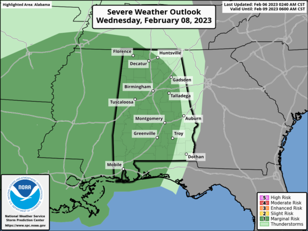
MIDWEEK FRONT: Clouds continue to increase Wednesday and with breezy southerly winds expect high again in the 70s statewide. An approaching cold front will being rain and storms back to Alabama Wednesday night into Thursday. The SPC has defined a low end “marginal risk” (level 1/5) of severe thunderstorms for much of the state in their “Day 3” outlook, which runs through 6AM. Thursday.
For now, the main batch of rain and storms will arrive after midnight Wednesday night, but with very little surface based instability, the severe weather threat rather low. However, we know it only takes one storm to make this a big event for Alabama.
As the storms move through, they could produce gusty winds, and brief, isolated tornado can’t be totally ruled out. Most of the rain will shift into East and South Alabama by Thursday afternoon.
FRIDAY AND THE WEEKEND: Friday will be cloudy and cooler as an upper trough moves through, and with wrap-around moisture, we expect patches of light rain/drizzle at times through the day, with highs in the 50s. The weekend will be dry with sunny days and fair nights. Highs will be in the 40s over the northern third of Alabama Saturday, with 50s to the south. Highs Sunday will be mostly in the 50s, after a sub-freezing start to the day.
NEXT WEEK: The weather will be dry Monday and Tuesday; rain returns at mid-week Wednesday. Temperatures rebound with highs in the 60s and 70s on most days, which would be above average for mid-February in Alabama.
BEACH FORECAST CENTER: Get the latest weather and rip current forecasts for the beaches from Fort Morgan to Panama City on our Beach Forecast Center page. There, you can select the forecast of the region that you are interested in visiting.
WORLD TEMPERATURE EXTREMES: Over the last 24 hours, the highest observation outside the U.S. was 109.0F at Augrabies Fall, South Africa. The lowest observation was -65.6F at Tongulah, Russia.
CONTIGUOUS TEMPERATURE EXTREMES: Over the last 24 hours, the highest observation was 85F at Marathon, FL. The lowest observation was -13F at Seagull Lake, MN.
Category: Alabama's Weather, ALL POSTS
About the Author (Author Profile)
Macon, Georgia Television Chief Meteorologist, Birmingham native, and long time Contributor on AlabamaWX. Stormchaser. I did not choose Weather, it chose Me. College Football Fanatic. @Ryan_StinnetSubscribe
If you enjoyed this article, subscribe to receive more just like it.


