Midday Nowcast: Wet and Stormy Thursday
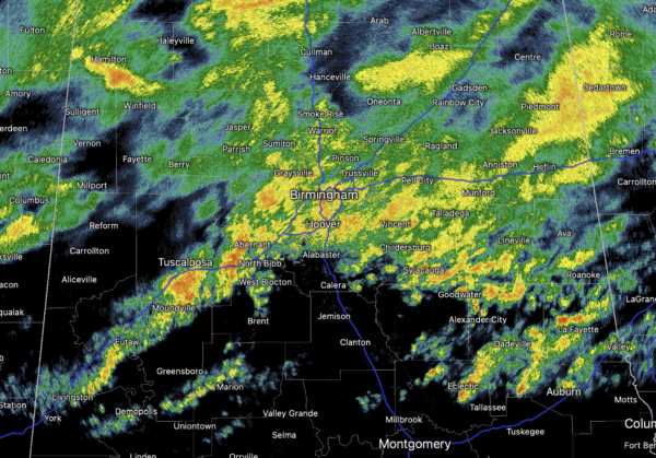
A wet and stormy morning across the northern half of Alabama, and we continue to deal with this activity this afternoon. Thankfully no severe storms in Alabama today, as the main threat of severe storms is west of the state where the SPC continues a level 4/5 “moderate risk” of severe storms this afternoon/evening for the ArkLaTex region. Near and around Shreveport, a severe weather outbreak, including the threat of strong tornadoes is possible today and into the overnight hours. Highs today are mainly in the 60S and 70s.
Tonight, showers will remain in the forecast with lows in the 60s. Our winds will increase tonight and wind advisory goes into effect for the entire state of Alabama. Winds tonight and through the day tomorrow, not related to thunderstorms, will average 20-25 mph, with gusts as high as 50 mph, which can cause tree and power issues.
STORMY START TO FRIDAY: The severe weather to our west looks will coalesce into a line on storms late tonight, reaching Alabama tomorrow morning, where it will race through the state during the morning hours. The SPC continues to have most of Alabama in a “slight risk” (level 2/5) during this time frame.
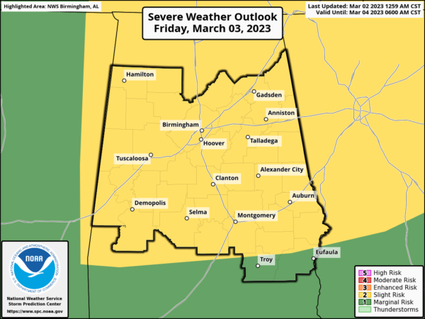
The line of storms will be capable of producing strong, potentially damaging winds. A brief, isolated tornado or two can’t be ruled out as well along the line. Be sure and pay attention to severe thunderstorm warnings Friday morning as they are issued. The overall timing of the event has the line reaching West Alabama around 6AM, Central Alabama closer to 8AM, and will be exiting into Georgia by noon. Behind the system, tomorrow afternoon will continue to feature very gusty winds, a clearing sky, and temperatures in the 70s.
WEEKEND WEATHER: A gorgeous weekend of weather is in store for Alabama with dry, sunny days and clear chilly nights. Lows drop into the 30s and 40s, while highs will be in the upper 60s Saturday, followed by 70s Sunday.
NEXT WEEK: Moisture levels rise, and showers are possible Monday across South Alabama. Then, we will have a chance of showers statewide Tuesday and Wednesday…no severe storms are expected with limited upper air support. Drier and slightly cooler air returns Thursday and Friday. Temperatures will be mainly in the 70s for much of the state next week, but 80s are expected across South Alabama.
RIP CURRENT AWARENESS WEEK: Know Before You Go! One of the best ways to be prepared for rip currents and other beach hazards is to know what you could be swimming into at the beach.
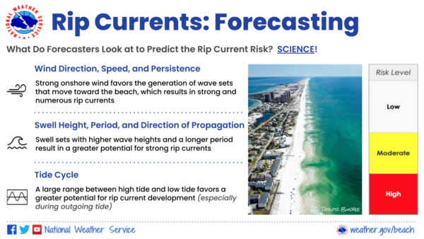
In addition to local expertise from our meteorologists, the National Weather Service runs a nearshore-wave model that helps forecast the potential rip current risk each day. The surf forecast is issued early each morning and updated later that morning after we receive updates from the local beach officials and lifeguards. Occasionally, lifeguards or beach officials will see that rip current conditions are evolving quicker or slower than our initial forecast, so we update the forecast to reflect the current conditions. More information on forecasts rip currents is below.
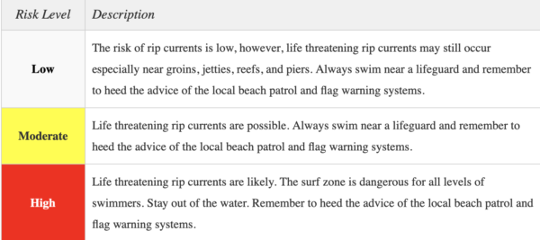
There are three tiers of qualifiers or “risk levels” in our beach forecasts – low, moderate, and high. High Risk is the highest level and means that the wind, swell, and/or tidal conditions are extremely favorable for the development of numerous deadly rip currents in the surf zone. A high risk means the surf is dangerous for ALL LEVELS of swimmers
BEACH FORECAST CENTER: Get the latest weather and rip current forecasts for the beaches from Fort Morgan to Panama City on our Beach Forecast Center page. There, you can select the forecast of the region that you are interested in visiting.
WORLD TEMPERATURE EXTREMES: Over the last 24 hours, the highest observation outside the U.S. was 109.4F at Garoua, Cameroon. The lowest observation was -74.9F at Vostok, Antarctica.
CONTIGUOUS TEMPERATURE EXTREMES: Over the last 24 hours, the highest observation was 105F at Falcon Lake, TX. The lowest observation was -19F at Seagull Lake, MN.
WEATHER ON THIS DATE IN 1975: The governor’s Tornado; in Atlanta did considerable damage to the governor’s mansion and surrounding areas resulting in three deaths and 56.5 million dollars damage.
Category: Alabama's Weather, ALL POSTS
About the Author (Author Profile)
Macon, Georgia Television Chief Meteorologist, Birmingham native, and long time Contributor on AlabamaWX. Stormchaser. I did not choose Weather, it chose Me. College Football Fanatic. @Ryan_StinnetSubscribe
If you enjoyed this article, subscribe to receive more just like it.


