Midday Nowcast: Warm Day, Strong Storms Overnight
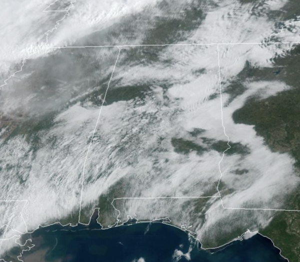
A warm and breezy day with highs surging into the 80s and an increasing southerly wind. The day is dry, but rain and storms return to Alabama tonight. To our west today, a significant severe weather outbreak will occur across the ARKLAMISS, where some strong tornadoes are possible, and the SPC has that region outlined in a “moderate risk” (level 4/5) of severe storms. Thankfully, we are not expecting that in Alabama, but as those storms push east into Alabama, we are going to have to deal with the risk of some severe storms in Alabama late tonight.
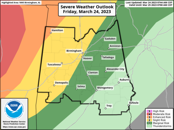
TONIGHT: There is an “enhanced risk” (level 3/5) of severe thunderstorms for the northwest corner of Alabama… a “slight risk” (level 2/5) extends as far east as Scottsboro, Birmingham, Brent, and Uniontown. A “marginal risk” (level 1/5) is defined down to Lake Martin, Hayneville, and Citronelle.
A broken line of strong to severe thunderstorms will move through the state during the overnight hours late tonight night and early tomorrow. The main threat will come from strong, potentially damaging straight line winds, but a few tornadoes are likely as well, especially in the “enhanced risk” area across Northwest Alabama…Some hail is possible as well.
With events like this it is very important that you have a way of hearing weather warnings in the middle of the night. The baseline for every home and business is a NOAA Weather Radio. Be sure your phone has WEA (Wireless Emergency Alerts) enabled, and “Do Not Disturb” or “Sleep Mode” are not active. Know the safe place in your home, and have helmets for everyone in the family there.
If you live in a mobile home, know the location of the nearest shelter (or business that is open 24/7 that can serve as a shelter), and the fastest way of getting there. Have transportation available. It sure isn’t convenient going to a shelter during the pre-dawn hours, but you can’t risk your life staying in a mobile home if you are in a tornado warning polygon.
Rain amounts will average 1/2 to 1 inch… for now flooding issues are not expected.
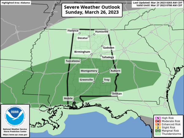
WEEKEND WEATHER: The rain and storms will be exiting the state early Saturday morning, and the day will feature improving weather. The sky becomes mostly sunny Saturday afternoon and the day will be warm with a high in the low 80s. For Sunday, the front will begin to lift back north Sunday, meaning clouds and rain will return to the state through the day. The air will be unstable, and strong storms are possible Sunday afternoon, with the main threats coming from strong winds and hail. The SPC has the southern two-thirds of the state outlined in a “marginal risk” (level 1/5) for this threat. The high Sunday will be in the upper 70s.
NEXT WEEK: Rain and storms remain in the forecast Monday and Tuesday as the air will be warm and unstable, allowing for the continues chance of some strong storms as well. Highs will remain in the upper 70s Monday and Tuesday. Dry and sunny weather returns for Wednesday and Thursday with highs in the 60s and 70s.
BEACH FORECAST CENTER: Get the latest weather and rip current forecasts for the beaches from Fort Morgan to Panama City on our Beach Forecast Center page. There, you can select the forecast of the region that you are interested in visiting.
WORLD TEMPERATURE EXTREMES: Over the last 24 hours, the highest observation outside the U.S. was 106.0F at Garoua, Cameroon. The lowest observation was -89.0F Vostok, Antarctica.
CONTIGUOUS TEMPERATURE EXTREMES: Over the last 24 hours, the highest observation was 100F at Rio Grande Village, TX. The lowest observation was -11F at Poplar, MT.
Category: Alabama's Weather, ALL POSTS
About the Author (Author Profile)
Macon, Georgia Television Chief Meteorologist, Birmingham native, and long time Contributor on AlabamaWX. Stormchaser. I did not choose Weather, it chose Me. College Football Fanatic. @Ryan_StinnetSubscribe
If you enjoyed this article, subscribe to receive more just like it.


