

Nice Warm-Up Today; Strong/Severe Storms Late Tomorrow Night
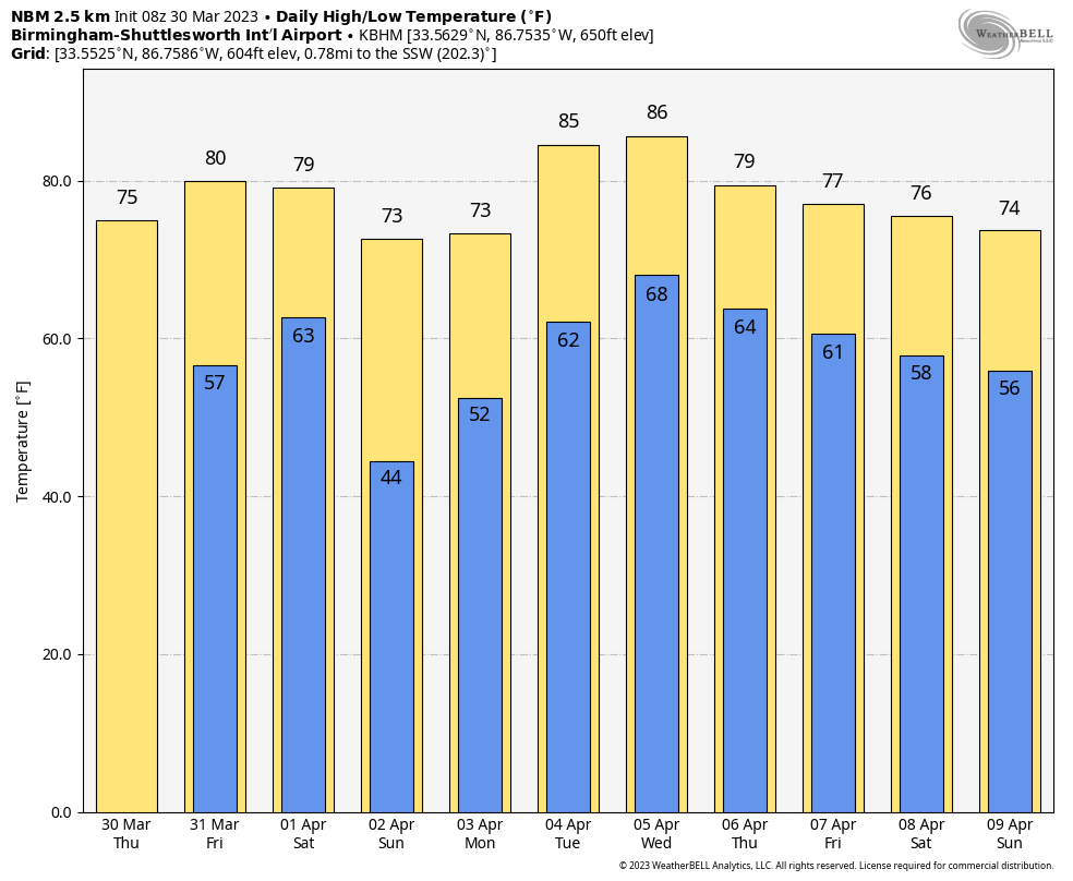
COLD START: We have some scattered light frost across North Alabama early this morning with temperatures in the 30s. Oneonta has actually dipped below the freezing mark with 31 degrees just before daybreak. Look for a nice warm-up today with ample sunshine… the high will be in the 70s. Tomorrow will be another dry, mild day with a high in the 77-80 degree range. South winds will increase during the afternoon ahead of an approaching storm system.
TOMORROW NIGHT: SPC maintains an “enhanced risk” (level 3/5) of severe thunderstorms for the northwest corner of Alabama around the Shoals. A “slight risk” (level 2/5) extends as far east as Gadsden, Hoover, and Eutaw. And, there is a “marginal risk” defined as far south as Heflin, Clanton, and Butler.
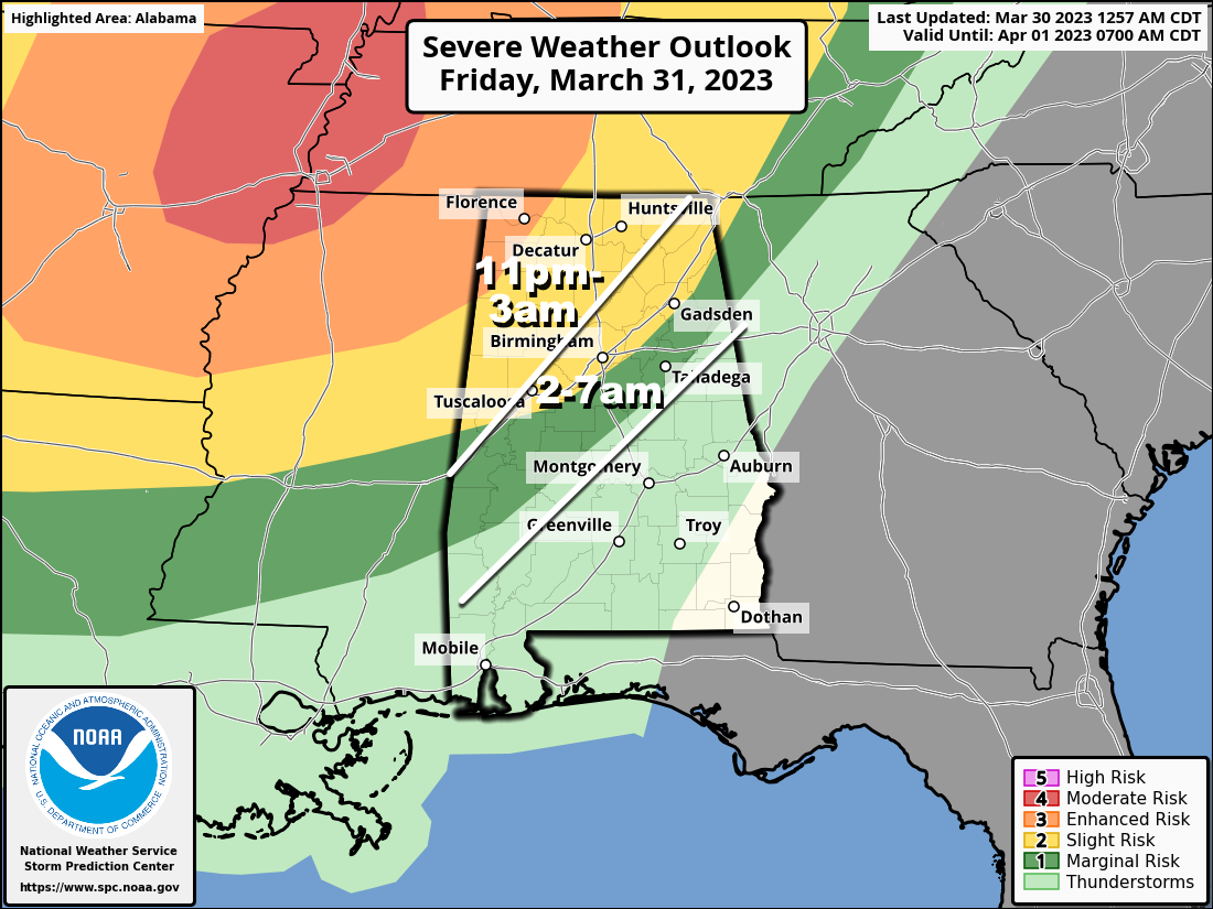
A line of thunderstorms will enter Northwest Alabama around midnight tomorrow night, then progressing southeastward through the pre-dawn hours Saturday. The primary threat will come from strong, potentially damaging winds, but an isolated tornado can’t be ruled out. Highest tornado probabilities are northwest of Alabama, where level a 4/5 “moderate risk” has been defined around Memphis.
While this system won’t pack the same punch as the one last Friday night, it is still very important to be able to hear warnings in the middle of the night as they are issued; the baseline is a NOAA Weather Radio. Be sure “Do Not Disturb” and “Sleep Mode” as disabled on your phone so you won’t miss any notifications.
Gradient winds will average 15-25 mph of the storms, with gusts to 30/35 mph possible in spots across North Alabama.
The weakening line of storms will shift into South Alabama Saturday morning, and should be out of the state by early afternoon. Severe storms are not expected across South Alabama Saturday. For North/Central Alabama… Saturday will be a dry day after the lingering early morning showers with a partly sunny sky and a high between 75 and 80 degrees.
Sunday will be a nice day; with a sunny sky the high will be in the low to mid 70s.
NEXT WEEK: Moist air returns Monday along with a chance of showers and thunderstorms. The weather stays unsettled with some risk of showers and storms on a daily basis through Thursday; too early to know if s severe storms will become an issue. Drier air returns at the end of the week Friday. Highs reach the mid 80s by Tuesday and Wednesday… See the video briefing for maps, graphics, and more details.
ON THIS DATE IN 1805: New York’s City’s Battery Park was strewn with 24-inch snow rollers, from a ferocious storm between the March 26th and March 28th. Snow rollers are natural snowballs that are formed when winds blow over a snow-covered surface.
ON THIS DATE IN 2022: A total of 16 tornadoes touched down across Alabama. The strongest was an EF3 that moved from Perry County into the southwest corner of Shelby County, close to Montevallo. Two were injured; tens of thousands of hardwood and softwood trees were snapped and uprooted along the tornado`s path during max intensity.
BEACH FORECAST: Click here to see the AlabamaWx Beach Forecast Center page.
Look for the next video briefing here by 3:00 this afternoon… enjoy the day!
Category: Alabama's Weather, ALL POSTS, Weather Xtreme Videos
About the Author (Author Profile)
James Spann is one of the most recognized and trusted television meteorologists in the industry. He holds the AMS CCM designation and television seals from the AMS and NWA. He is a past winner of the Broadcast Meteorologist of the Year from both professional organizations.Subscribe
If you enjoyed this article, subscribe to receive more just like it.


