Summer-Like Temps Tomorrow/Wednesday
RADAR CHECK: We have a few scattered showers across East and South Alabama at mid-afternoon, but much of the state is dry. A warm front is moving slowly northward; we have a big temperature contrast on either side of the front. Mobile is up to 84 degrees at 2:00p CT, while Huntsville is at 61 on the north side of the front. Showers and storms are still expected to form along and south of the warm front over the next few hours, and SPC maintains a low end “marginal risk” of severe thunderstorms for areas south of a line from Kennedy to Alabaster to Tuskegee to Phenix City.
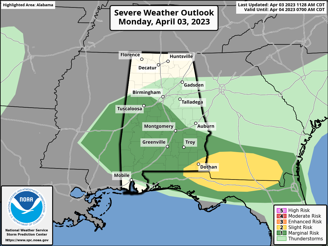
Stronger storms that form this evening could produce hail and strong gusty winds. The tornado threat is low.
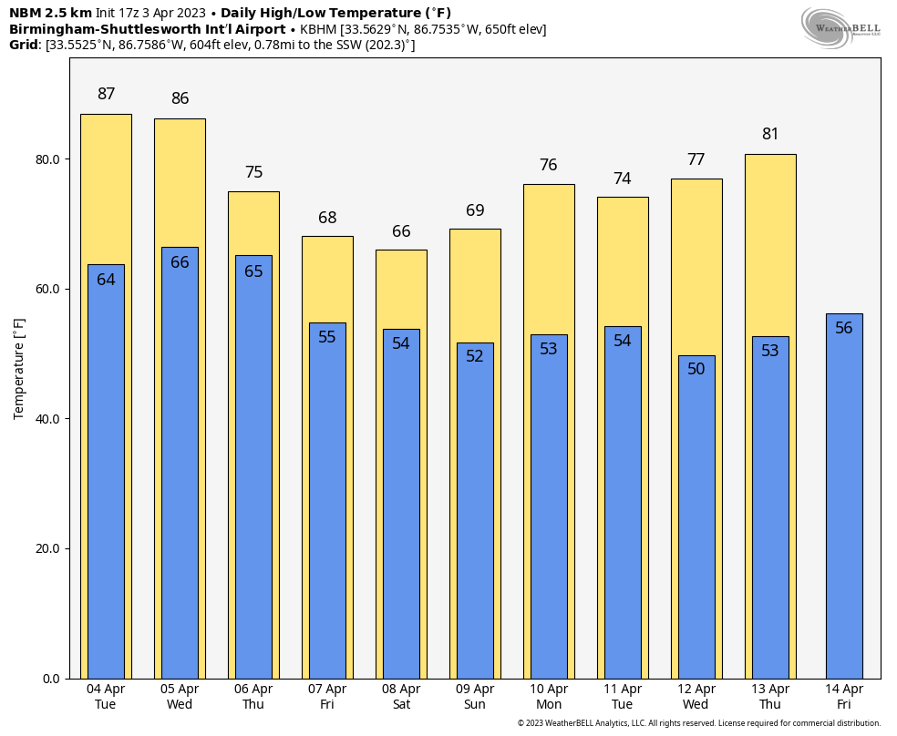
TOMORROW/WEDNESDAY: We expect the warmest weather so far this year with highs in the 80s statewide. Much of the state will be dry tomorrow and Wednesday with only isolated showers or storms. A band of rain and thunderstorms will likely push slowly into North Alabama Wednesday night… SPC maintains a “marginal risk” (level 1/5) of severe thunderstorms for areas north of a line from Demopolis to Pelham to Alexandria.
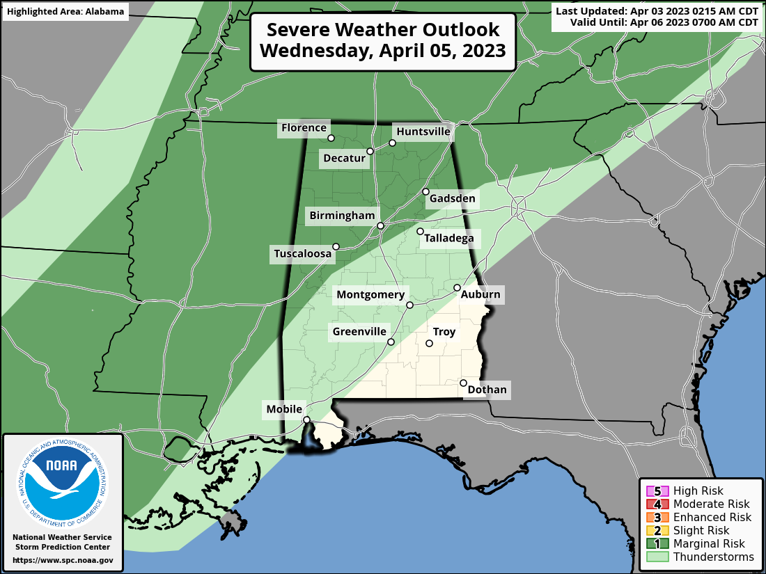
Storms Wednesday night could produce gusty winds, but the weak dynamic support and limited instability the overall threat looks low at this point.
THURSDAY/FRIDAY: The front will stall out over Central Alabama, and periods of rain are likely both days with potential for a few thunderstorms as well. There will be a big thermal contrast across the state due to the front; highs range from the 60s across North Alabama to the 80s over the southern quarter of the state.
EASTER WEEKEND: We will maintain the chance of rain at times on Saturday, but at this point Easter Sunday looks generally dry with a partly sunny sky. The big temperature range will continue Saturday with 60s for North Alabama, 70s for the central counties, and 80s near the coast. The high Sunday will be mostly in the 70s statewide.
NEXT WEEK: Model guidance remains inconsistent, and forecast confidence remains low. A disturbance will likely bring a chance of rain Monday night or Tuesday, followed by dry weather for the rest of next week. Models are trending a bit warmer, and odds of a late season frost/freeze by mid-week are lower. See the video briefing for maps, graphics, and more details.
ON THIS DATE IN 1974: The 1974 Super Outbreak underway. It was the second-largest tornado outbreak on record for a single 24-hour period, just behind the 2011 Super Outbreak. It was also the most violent tornado outbreak ever recorded, with 30 F4/F5 tornadoes confirmed. From April 3–4, 1974, there were 148 tornadoes confirmed in 13 U.S. states and the Canadian province of Ontario.
In Alabama, at least eight tornadoes, including four extremely intense and long-lived storms, brought death and extreme storm destruction that night. The communities of Guin and Jasper were hit hard. Eighty-six persons were killed, 949 were injured.. Sixteen counties in the northern part of the state were hit the hardest. It ranks as the third deadliest tornado outbreak in Alabama history. It is surpassed by the tornado outbreak of March 21, 1932, when over 300 people died in a series of tornadoes, as well as the historic outbreak of April 27, 2011, when 252 Alabamians lost their lives.
ON THIS DATE IN 1987: A surprise snow event in Alabama. Parts of the state had over five inches of snow; one inch was measured down to Montgomery. It is the biggest April snow event on record in the state. Birmingham’s official total was six inches.
BEACH FORECAST: Click here to see the AlabamaWx Beach Forecast Center page.
Look for the next video briefing here by 6:00 a.m. tomorrow…
Category: Alabama's Weather, ALL POSTS, Weather Xtreme Videos
About the Author (Author Profile)
James Spann is one of the most recognized and trusted television meteorologists in the industry. He holds the AMS CCM designation and television seals from the AMS and NWA. He is a past winner of the Broadcast Meteorologist of the Year from both professional organizations.Subscribe
If you enjoyed this article, subscribe to receive more just like it.


