Cool/Wet Day Tomorrow; Dry Easter Sunday
RADAR CHECK: Rain is widespread this afternoon across much of North and West Alabama, along and north of the slow moving front draped across the state. Again today we have a wide range of temperatures… at 2:00p CT Haleyville reports 49 degrees with rain, while Dothan is enjoying a mostly sunny sky and 83 degrees.
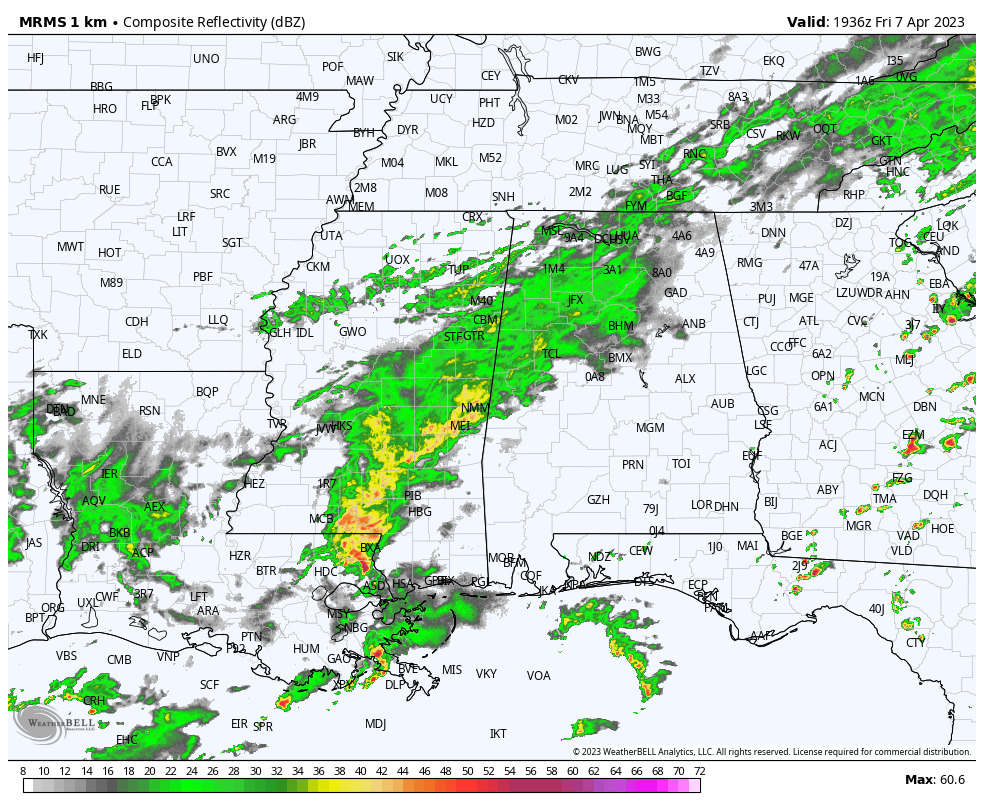
Rain will be widespread across the northern half of the state tonight with temperatures dropping into the 48-55 degree range.
EASTER WEEKEND: Rain will continue much of the day tomorrow, but it will end from northwest to southeast during the midday and afternoon hours. By mid-afternoon most of the rain will be from Birmingham south and east. It will be a cool day with highs in the 55-65 degree range for the northern 2/3 of the state… 70s are likely for the southern counties.
Easter Sunday will be dry… the sky becomes partly to mostly sunny with highs in the 60s and 70s.
NEXT WEEK: Dry weather continues Monday and Tuesday with highs holding in the 60s and 70s. An upper low is forecast to form around the Gulf Coast by mid-week with a surface low as well. This feature will likely bring some rain back into Alabama Thursday and Friday… rain could begin across South Alabama as early as Wednesday. See the video briefing for maps, graphics, and more details.
One positive note… we see no significant chance of severe thunderstorms for Alabama for at least the next seven days.
ON THIS DATE IN 1948: Six tornadoes ripped through Northern Illinois and Indiana; mainly across the southern and eastern suburbs of Chicago. The hardest hit was from a tornado that moved east from near Manteno, IL to near Hebron, Indiana. This storm left four people dead; three in Grant Park, IL and one near Hebron, IN
ON THIS DATE IN 1980: Severe thunderstorms spawned tornadoes that ripped through central Arkansas. The severe thunderstorms also produce high winds and baseball size hail. Five counties were declared disaster areas by President Carter. A tornado causing F3 damage also affected St. Louis and St. Charles counties in Missouri producing $2.5 million in damage.
BEACH FORECAST: Click here to see the AlabamaWx Beach Forecast Center page.
Look for my next video briefing here by 6:00 a.m. Monday… enjoy the weekend and Happy Easter!
Category: Alabama's Weather, ALL POSTS, Weather Xtreme Videos
About the Author (Author Profile)
James Spann is one of the most recognized and trusted television meteorologists in the industry. He holds the AMS CCM designation and television seals from the AMS and NWA. He is a past winner of the Broadcast Meteorologist of the Year from both professional organizations.Subscribe
If you enjoyed this article, subscribe to receive more just like it.


