Midday Nowcast: Splendid Spring Weather
Today and tomorrow will continue to feature more sun than clouds and afternoon highs mainly in the low to upper 70s both days. Nights will remain chilly with lows in the 40s. We stay dry through tomorrow, but a few showers are possible today and tomorrow across Southwest Alabama. We are watching a developing low pressure in the northwestern Gulf of Mexico as it will begin to spread rain and storms northward across Louisiana and Mississippi today.
RAIN RETURNS: As the Gulf low moves northward through Mississippi, widespread occasional rain will move into Central and North Alabama Thursday. The SPC has introduced a low end “marginal risk” of severe thunderstorms for the southeast counties of the state Thursday, for areas east of a line from Roanoke to Prattville to Atmore.
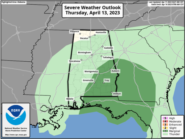
A few storms in these areas could produce strong gusty winds and small hail Thursday afternoon. A brief tornado can’t be totally ruled out, but isn’t likely. A few lingering showers are possible Friday, mainly over North Alabama, as the surface low continues to move northward. Expect highs in the 70s both Thursday and Friday.
Rainfall amounts will be unevenly distributed across the state; ranging from a quarter-of-an-inch for portions of North Alabama, while portions of South Alabama could receive over two inches.
THE ALABAMA WEEKEND: Most of the state will be dry and warm Saturday with a high in the low to mid 80s. On Sunday, a cold front will bring some rain and perhaps a few storms back to Alabama; but severe storms are not expected. Highs Sunday will be in the 70s.
NEXT WEEK: Behind the front, a dry airmass will settle into the state Monday, and for now much of the week looks dry and pleasant with mild afternoons and cool nights. Highs Monday will be in the 70s, and we should see 80s the rest of the week.
BEACH FORECAST CENTER: Get the latest weather and rip current forecasts for the beaches from Fort Morgan to Panama City on our Beach Forecast Center page. There, you can select the forecast of the region that you are interested in visiting.
WORLD TEMPERATURE EXTREMES: Over the last 24 hours, the highest observation outside the U.S. was 110.5F at Ndjamena, Chad. The lowest observation was -94.0F Amundsen-Scott South Pole Station, Antarctica.
CONTIGUOUS TEMPERATURE EXTREMES: Over the last 24 hours, the highest observation was 101F at Death Valley, CA. The lowest observation was 2F at Peter Sinks, UT.
Category: Alabama's Weather, ALL POSTS
About the Author (Author Profile)
Macon, Georgia Television Chief Meteorologist, Birmingham native, and long time Contributor on AlabamaWX. Stormchaser. I did not choose Weather, it chose Me. College Football Fanatic. @Ryan_StinnetSubscribe
If you enjoyed this article, subscribe to receive more just like it.


