Showers Today; Temps Below Average
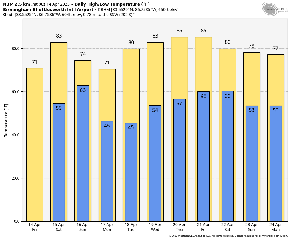
RADAR CHECK: Showers are in progress early this morning across parts of North and Central Alabama, under an upper low that is moving northeast. We will maintain the chance of scattered showers through the day with a mostly cloudy sky… expect a high in the 67-73 degree range this afternoon. The average high for Birmingham on April 14 is 75. Showers will end this evening, and tonight will be generally dry with a fair sky.
THE WEEKEND: A batch of showers and storms will likely move across the far southern counties of the state during the day tomorrow, but for the northern 2/3 of the state we expect a partly sunny sky with only isolated afternoon showers. The day will be warm with a high between 77 and 83 degrees.
A cold front will bring showers to the entire state tomorrow night into Sunday. There could be some thunder, but severe storms are not expected across North/Central Alabama with very limited instability and weak dynamics. Most of the showers will come from midnight tomorrow night through noon Sunday. A few strong storms could fire up Sunday afternoon over the southeast corner of the state, however. The high Sunday will be close to 70 degrees.
NEXT WEEK: For now the entire week looks dry with sunny days and fair nights, an unusual five day stretch of dry weather in April. Highs will be in the 70s Monday and Tuesday, followed by low to mid 80s over the latter half of the week. See the video briefing for maps, graphics, and more details.
ON THIS DATE IN 1912: On her maiden voyage, the RMS Titanic rammed into an iceberg just before midnight. The “unsinkable ship” sank two hours and forty minutes later into the icy water of the Atlantic Ocean near Newfoundland, Canada. Tragically, 1,517 passengers including the crew were lost. A nearby ship, the Carpathia, rushed to the Titanic and was able to save 706 people.
ON THIS DATE IN 1935: Black Sunday refers to a particularly severe dust storm that occurred on April 14, 1935, as part of the Dust Bowl. During the afternoon, the residents of the Plains States were forced to take cover as a dust storm, or “black blizzard,” blew through the region. The storm hit the Oklahoma Panhandle and Northwestern Oklahoma first and moved south for the remainder of the day. It hit Beaver around 4:00 p.m., Boise City around 5:15 p.m., and Amarillo, Texas, at 7:20 p.m. The conditions were the most severe in the Oklahoma and Texas panhandles, but the storm’s effects were felt in other surrounding areas.
BEACH FORECAST: Click here to see the AlabamaWx Beach Forecast Center page.
Look for the next video briefing here by 3:00 this afternoon… enjoy the day!
Category: Alabama's Weather, ALL POSTS, Weather Xtreme Videos
About the Author (Author Profile)
James Spann is one of the most recognized and trusted television meteorologists in the industry. He holds the AMS CCM designation and television seals from the AMS and NWA. He is a past winner of the Broadcast Meteorologist of the Year from both professional organizations.Subscribe
If you enjoyed this article, subscribe to receive more just like it.


