Sunday Weather Briefing: A Nice Week Ahead
Saturday was a beautiful day for the most part across North and Central Alabama. The day dawn most sunny except for some foggy spots across the northern half of the state, mainly near bodies of water. After the fog burned away, temperatures warmed from the upper 40s and 50s into the 70s and even lower 80s. A complex of thunderstorms developed into a mesoscale convective vortex over Southeast Texas and Louisiana and it moved east northeast across Mississippi during the afternoon. There were a few reports of damaging winds and large hail. As it moved across South Alabama, it triggered severe thunderstorm warnings for several counties along its path. Winds gusted to 58 mph in Loxley. But the airmass over much of Alabama was much drier than the one the complex was used to, and storms exhibited a gradual weakening trend as they pushed deeper into our state. In fact, the comma head feature of the MCV became detached from the line of storms and they progressed eastward without the head. It caused wind gusts to 36 mph at Montgomery. Showers and storms pushed across Central and South Alabama into the evening hours, but they were much weaker and the rain barely reached as far north as just south of Birmingham.
SATURDAY WEATHER PART TWO: A line of storms developed ahead of a cold front across Arkansas and eastern Oklahoma during the afternoon. Storms became severe across Arkansas and later over Northern Louisiana and the line marched eastward into Mississippi during the late evening. A tornado was reported on the ground at Ringgold, LA in Bienville Parish southeast of Shreveport. These storms are really falling apart early this morning, however, and the threat of severe weather is going to skip over much of Alabama.
FOR YOUR SUNDAY: A few showers continued to diminish during the pre-dawn hours, leaving most of North and Central Alabama dry by sunrise. A few showers are possible along the actual front over North and Northeast Alabama early this morning though. Clouds will be slow to break up, with clearing not reaching areas south of I-59 until mid-afternoon or later. Clouds should clear completely overnight, however. After most of us start the day in the upper 50s and lower 60s, afternoon readings will climb into the upper 60s northwest of I-59, with lower 70s to the southeast. Most everyone makes it into the 40s overnight tonight.
SEVERE WEATHER THREAT: That severe threat that hopped over much of North and West Alabama will not get re-energized this afternoon until it is into South Georgia and the Florida Peninsula, it appears, which is good news.
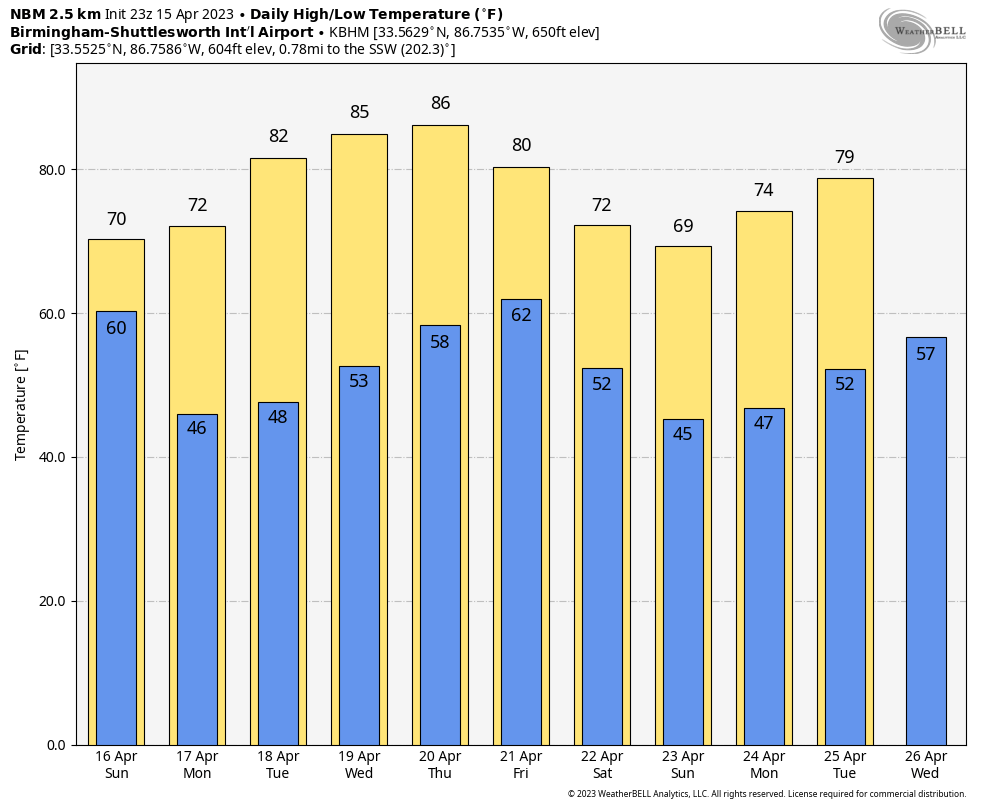
NICE STRETCH OF WEATHER THIS WEEK: Behind the front, total sunshine, mild temperatures, and a fresh northerly breeze will prevail for your Monday with highs mostly in the lower and middle 70s. The lone exception will be Northeast Alabama, where highs may not get out of the 60s. Most everyone will be back in the 40s Monday night. Tuesday will feature mostly sunny skies, with highs reaching near 80 degrees. Wednesday and Thursday look warm and dry with lows in the 50s and highs in the lower and middle 80s. The only potential fly in the ointment will be some showers and isolated storms that might develop late Thursday as the high protecting the Southeast breaks down.
FRIDAY RAIN AND STORMS: A wide band of showers and storms will push into Alabama on Friday it looks like, taking its time to exit the state on Saturday. Most of the area will get a good soaking from this system, with one-half to one inch of rain generally, although some spots may get as much as two inches. There is some potential for severe weather on Friday with the slower progression of the system. We will be watching for that.
SUNDAY IMPROVING: It will be clearing and cooler for your Sunday, with highs in the 70s.
WEEK TWO VOODOO: Dry until Wednesday the 26th, and that system has a severe weather look to it, so keep that in mind. Plenty of time to watch it though.
BEACHCAST: An absolutely beautiful week along the gorgeous beaches of Alabama and Northwest Florida. Any rain moves out early this morning and then the next chance of rain holds off til late Thursday. Not great news for the weekend, but the week will be fine. Highs will be in the 70s to near 80F. Lows will trend upwards from the 50s into the lower 60s. We have already had fatalities this year along the northern Gulf Coast in rip currents, so let’s pay attention to the flags. They should be yellow and green through much of this week, but be careful anytime you or your family goes in the water.
Click here to see the Beach Forecast Center page.
NATIONALLY: Areal flood watches are in effect for the Northern Sierra Mountains, where snowmelt is causing rivers to run high and fast, and causing flooding of low water crossings. They have a lot of snow to melt for sure.
DANCING WITH THE STATS: 93F at Fort Myers, FL yesterday broke the record of 92F for the date. Lakeland FL also tied their record for the date with a high of 92F.
ADVERTISE WITH US: Deliver your message to a highly engaged audience by advertising on the AlabamaWX.com website. We have a lot of big plans for this year. Don’t miss out! We can customize a creative, flexible, and affordable package that will suit your organization’s needs. Contact me, Bill Murray, at (205) 687-0782, and let’s talk.
WEATHERBRAINS: This week, the panel will talk to author Jim Minick and his outstanding book Without Warning, the story of the 1955 Udall KS tornado. Check out the show at www.WeatherBrains.com. You can also subscribe on iTunes. You can watch the show live on our new YouTube channel for the show. You will be able to see the show on the James Spann 24×7 weather channel on cable or directly over the air on the dot 2 feed.
ON THIS DATE IN 2014: A quick shot of arctic air caused a late-season freeze over North and Central Alabama. Birmingham and Auburn hit 32F, as did Decatur. But the freezing conditions only lasted for a couple of hours as winds remained up through the night and the atmosphere did not decouple until right before sunrise, allowing the mercury to drop those last few degrees. The coldest official reading in the state was 27F at Valley Head. Follow my weather history tweets on Twitter. I am @wxhistorian at Twitter.com.
Category: Alabama's Weather, ALL POSTS
About the Author (Author Profile)
Bill Murray is the President of The Weather Factory. He is the site's official weather historian and a weekend forecaster. He also anchors the site's severe weather coverage. Bill Murray is the proud holder of National Weather Association Digital Seal #0001 @wxhistorianSubscribe
If you enjoyed this article, subscribe to receive more just like it.


