Mostly Dry Today; Showers Return Tomorrow
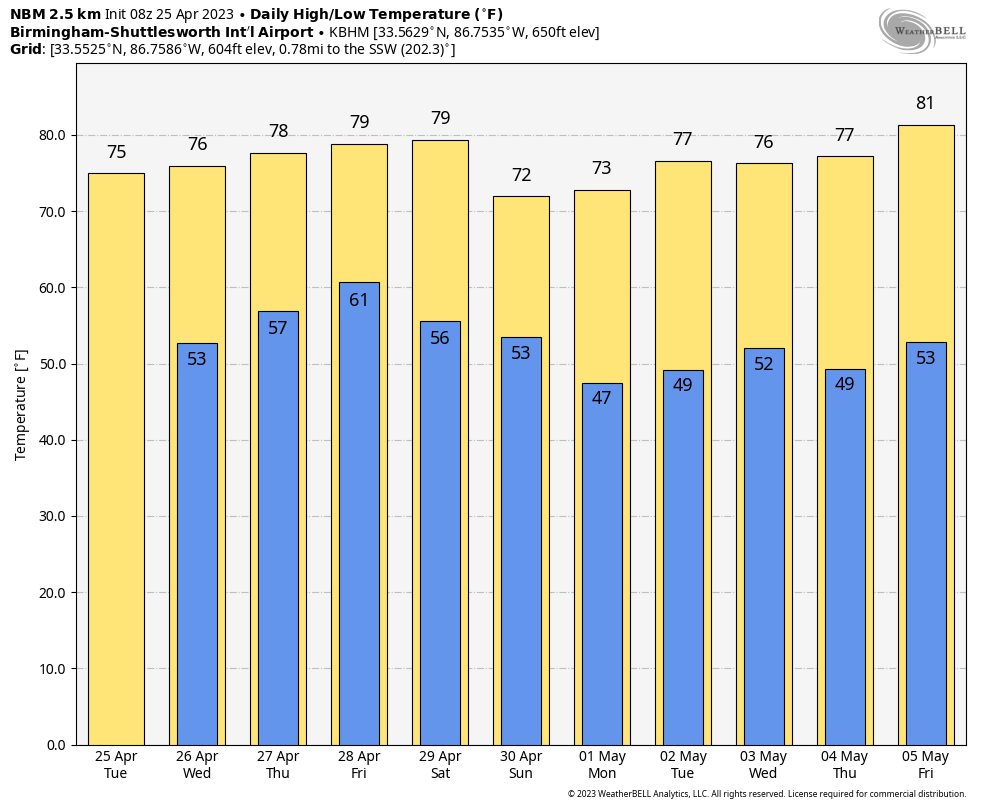
CHILLY START: Colder spots have dipped into the mid to upper 30s across North Alabama early this morning. Colder temperatures at 5:00 a.m. include 36 at Cullman, 37 at Jasper and Haleyville, and 38 at Gadsden. Most places are in the 40s and 50s… expect a high between 70 and 75 degrees today with a partly sunny sky. A sprinkle can’t be totally ruled out this afternoon or tonight, but the low levels are very dry and meaningful rain is not expected.
We will bring in the chance of showers tomorrow as moisture levels rise. Not raining all day, and nothing too heavy. Otherwise, tomorrow will be mostly cloudy with a high in the 70s.
THURSDAY: A wave aloft will bring showers and thunderstorms to the state Thursday. SPC has introduced a low end, “marginal risk” of severe thunderstorms for the southern 3/4 of the state, for areas south of a line from Hamilton to Cullman to Gadsden.
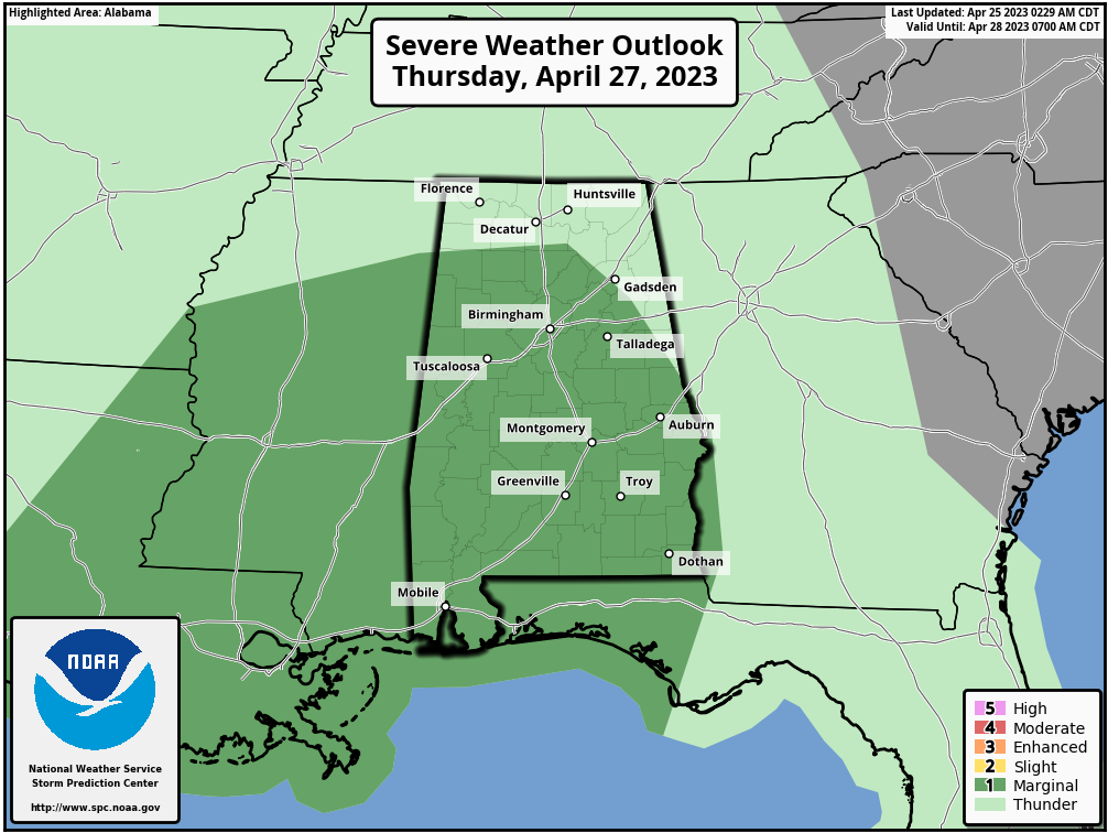
A few of the stronger storms could produce small hail and gusty winds, but for now this doesn’t look like a tornado setup with the best dynamic support displaced to the north, away from the better instability. Better chance of the heavier thunderstorms will come during the late morning and afternoon hours, and the high will remain in the 70s.
FRIDAY AND THE WEEKEND: Friday will feature more clouds than sun, and we can’t rule out a few scattered showers as a fairly moist airmass will remain in place across Alabama. But a decent part of the day will be dry.
The next wave will bring another round of showers and thunderstorms to the state over the weekend. Latest model trends suggest we could get away with a mostly dry day Saturday with a high in the 70s… the most widespread rain will come Saturday night into part of the day Sunday. For the moment severe storms are not expected with very little surface based instability available. Clouds will linger through the day Sunday with highs in the 67-73 degree range.
NEXT WEEK: While much of the week looks dry for now, we will mention a chance of showers Tuesday night into Wednesday morning as a wave passes through the region. Highs will be generally in the 70s… See the video briefing for maps, graphics, and more details.
ON THIS DATE IN 1880: A violent tornado, at times up to 400 yards wide, swept away at least 20 homes in Macon, Mississippi. Pieces of houses were found 15 miles away. 22 people died, and 72 were injured. Loaded freight cars were thrown 100 yards into homes. Clothes were carried for eight miles.
ON THIS DATE IN 1990: Thunderstorms produced severe weather from Texas to Nebraska. Thunderstorms spawned fifteen tornadoes, including a powerful F4 tornado near Weatherford, Texas. Between 3 PM and 8 PM, a storm complex tracking northeastward across central Kansas spawned four tornadoes along a 119-mile path from Ness to Smith Center, with the last tornado on the ground for 55 miles.
Look for the next video briefing here by 3:00 this afternoon…
Category: Alabama's Weather, ALL POSTS, Weather Xtreme Videos
About the Author (Author Profile)
James Spann is one of the most recognized and trusted television meteorologists in the industry. He holds the AMS CCM designation and television seals from the AMS and NWA. He is a past winner of the Broadcast Meteorologist of the Year from both professional organizations.Subscribe
If you enjoyed this article, subscribe to receive more just like it.


