Showers/Storms Possible Through Tomorrow; A Few Strong Storms
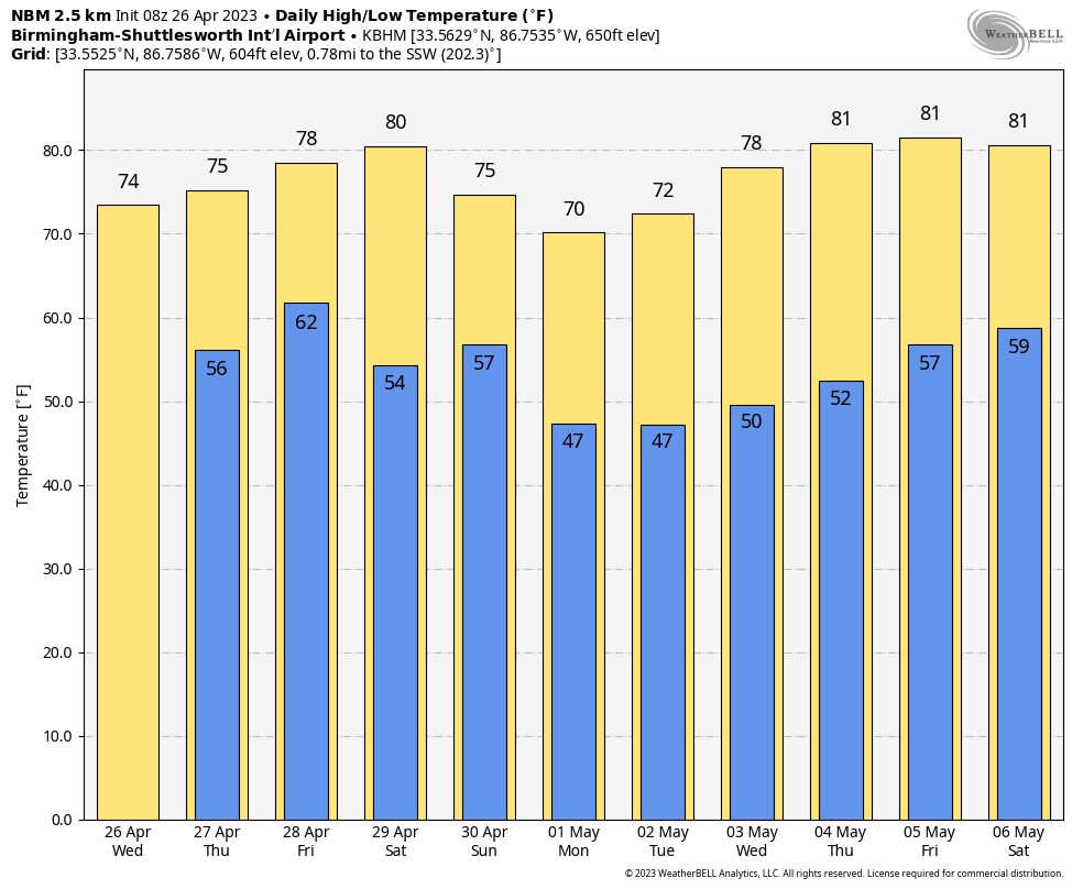
RADAR CHECK: Showers are over the northern third of Alabama early this morning; those are moving eastward and will be in Georgia by mid-morning. Additional scattered showers and thunderstorms will form this afternoon and tonight, but it certainly won’t rain all day today and you might see a peek or two of sun this afternoon. The high today will be in the 68-74 degree range.
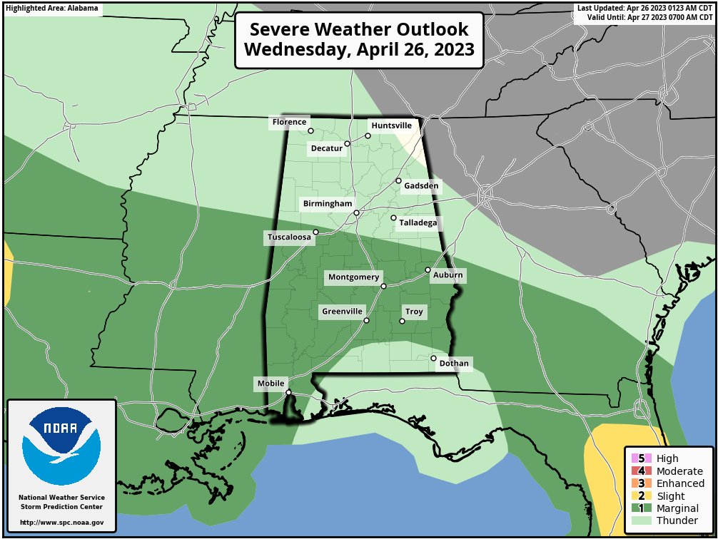
We do note SPC has introduced a very low end, “marginal risk” of severe thunderstorms for parts of Central and South Alabama this afternoon; a few storms could produce small hail and gusty winds. No tornado threat today.
TOMORROW: An organized area of rain and storms will push through the state tomorrow, and SPC has defined a “slight risk” (level 2/5) of severe thunderstorms for South Alabama… for areas south of a line from Grove Hill to Greenville to Eufaula. A “marginal risk” (level 1/5) extends as far north as Decatur and Huntsville.
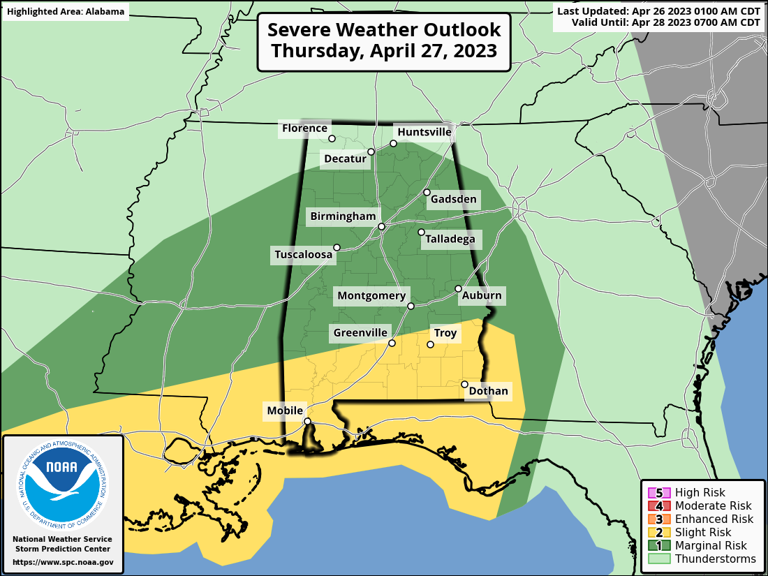
The core threat of heavier storms will be over the southern quarter of the state, where the air will be most unstable. The main threats will come from small hail and strong straight line winds, but an isolated tornado can’t be ruled out… especially across Mobile and Baldwin counties. Rain will be heavy at times across South Alabama, where rain amounts could exceed one inch.
The risk of severe thunderstorms over the northern half of the state is low, and there is no tornado threat there. Rain amounts over North Alabama will be generally 1/2 inch or less.
The core window for rain tomorrow will come from 10am until 5pm; any lingering showers tomorrow night should be few and far between.
FRIDAY AND THE WEEKEND: We will mention the risk of a stray shower Friday morning, but a decent part of the day will be dry with potential for some clearing by afternoon. The high Friday will be in the mid 70s.
Models continue to struggle with the weekend pattern; we will continue to use the reliable European global model, which suggests Saturday will be a dry, mild day with a high in the 70s. Rain will return Saturday night into Sunday with the next wave; for now severe storms are not expected, and the most widespread rain will likely come across the southern half of the state. The high Sunday will be close to 70 degrees.
NEXT WEEK: Much of next week looks dry at this point with highs mostly in the 70s. See the video briefing for maps, graphics, and more details.
ON THIS DATE IN 1986: The Chernobyl nuclear power station in Kiev Ukraine suffered a massive explosion. The radioactive cloud of particles and gas carried westward and northwestward, contaminating large areas of Europe in the following week.
ON THIS DATE IN 2011: A total of 55 tornadoes touched down across several states, including Texas, Louisiana, Arkansas. Most of those tornadoes were weak, but a few of them caused considerable damage. A long-tracked wedge tornado caused EF-2 damage in rural portions of Texas and Louisiana. It was the beginning of the “Super Outbreak” of tornadoes that would peak on the next day, April 27, 2011.
Look for the next video briefing here by 3:00 this afternoon… enjoy the day!
Category: Alabama's Weather, ALL POSTS, Weather Xtreme Videos
About the Author (Author Profile)
James Spann is one of the most recognized and trusted television meteorologists in the industry. He holds the AMS CCM designation and television seals from the AMS and NWA. He is a past winner of the Broadcast Meteorologist of the Year from both professional organizations.Subscribe
If you enjoyed this article, subscribe to receive more just like it.


