SPC Mesoscale Discussion:
Storms have formed over western Alabama this afternoon as expected. The strongest storms right now are over southwestern Winston and southeastern Marion Counties in Northwest Alabama, near Lynn, down to Winfield.
Other strong storms are near York and Livingston in Sumter County.
The airmass ahead of the storms is unstable, with CAPE values running 2000-3000 joules/kg. There is modest speed shear, but poor mid-level lapse rates. So, only a few reports of wind damage or large hail are expected and the SPC doesn’t expect to need a weather watch.
We will be monitoring all afternoon as the storms progress southeastward. They should be out of the area by 8 p.m. tonight.
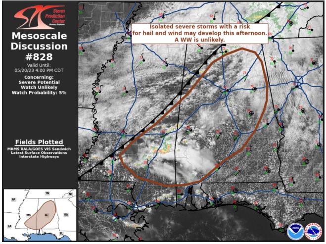
Mesoscale Discussion 0828
NWS Storm Prediction Center Norman OK
0135 PM CDT Sat May 20 2023
Areas affected…portions of central and western Alabama into
southeastern Mississippi
Concerning…Severe potential…Watch unlikely
Valid 201835Z – 202100Z
Probability of Watch Issuance…5 percent
SUMMARY…Isolated strong to severe storms may evolve this afternoon
with a risk for a few damaging wind gusts and marginally severe
hail. Lower-end storm coverage and intensity suggest a weather watch
is likely not needed.
DISCUSSION…As of 1825 UTC, regional radar imagery showed isolated
thunderstorms along and east of a slow-moving frontal zone and MCV
over MS and AL have slowly intensified over the last hour.
Additional incipient storm development was noted farther north into
portions of northwestern AL where deepening cumulus has been
observed via regional satellite. Ahead of these developing storms,
clear skies and warming temperatures have allowed moderate buoyancy
(1500-2000 J/kg MLCAPE) to develop despite poor mid-level lapse
rates of 5.5-6 C/km. Mostly unidirectional flow observed via area
VWPs suggests relatively low potential for storm organization with
effective shear of 25-30 kt favoring multicells and perhaps a
transient supercell structure. Given the moderate buoyancy and some
potential for storm organization, isolated damaging wind gusts and
some marginally severe hail may be possible with the more persistent
storms. Given the rather nebulous forcing and lack of broader
organization a weather watch is unlikely.
..Lyons/Grams.. 05/20/2023
Category: Alabama's Weather, ALL POSTS, Severe Weather
About the Author (Author Profile)
Bill Murray is the President of The Weather Factory. He is the site's official weather historian and a weekend forecaster. He also anchors the site's severe weather coverage. Bill Murray is the proud holder of National Weather Association Digital Seal #0001 @wxhistorianSubscribe
If you enjoyed this article, subscribe to receive more just like it.


