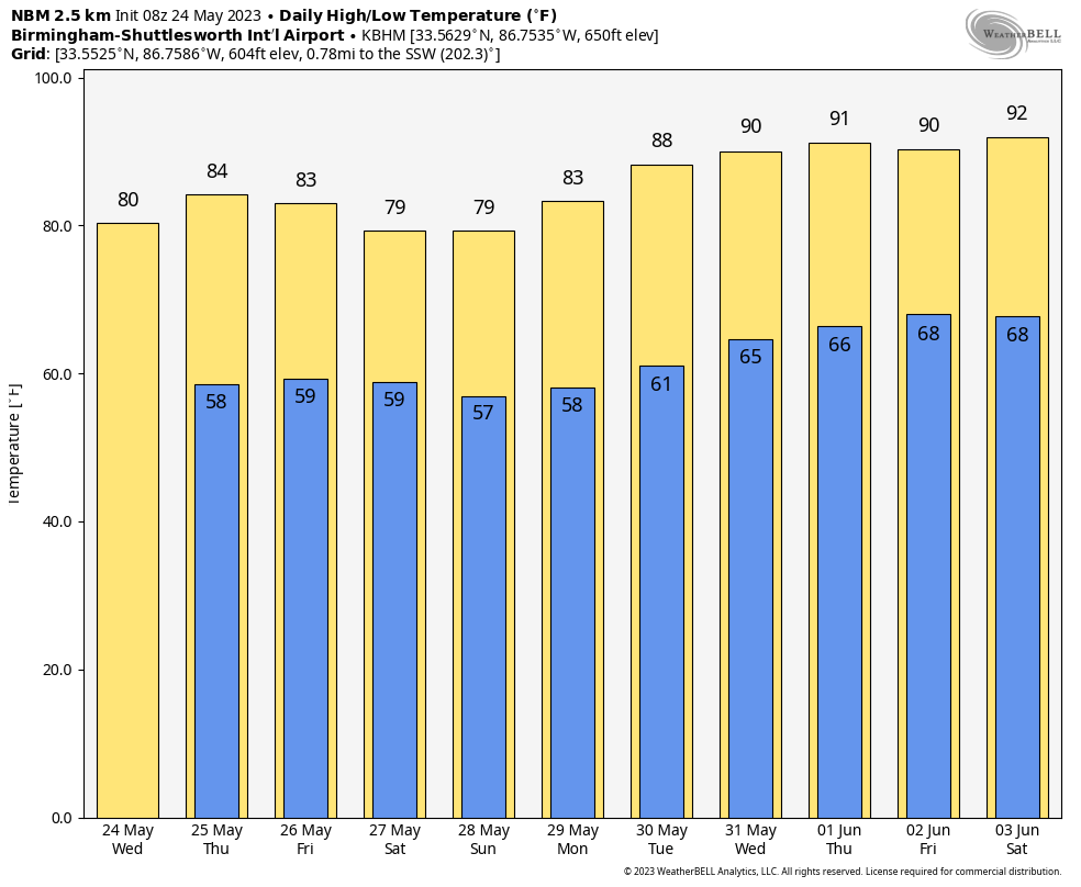
Lingering Showers This Morning; Dry Tomorrow
RADAR CHECK: We have some “illegal” rain across Central Alabama early this morning (that means rain was wasn’t forecast)… mostly south of I-20. Models have not handled this pattern well; there is an upper low involved along with a nearly stationary front over the southern counties of the state. We will need to maintain the chance of some lingering scattered light rain today, but a decent part of the state will be dry with a mix of sun and clouds. Expect a high in the 78-82 degree range this afternoon; Birmingham’s average high for May 24 is 84.
A more meaningful push of dry air arrives tomorrow; the sky will be mostly sunny with a high in the mid 80s.
FRIDAY AND THE HOLIDAY WEEKEND: The weather still looks favorable Friday through Monday across Alabama with generally dry conditions and below average temperatures. A surface low will form east of the state, and showers are likely across Georgia and the Carolinas; for now we will mention only isolated showers each day for Alabama, mostly during the afternoon and evening hours. The chance of any one spot getting wet daily is 15-20 percent. Otherwise, expect partly to mostly sunny days and fair nights. The high Friday will be close to 80, followed by mid to upper 70s Saturday and Sunday. Monday’s high will be in the low 80s for Memorial Day.
REST OF NEXT WEEK: The weather looks fairly quiet with just a few widely scattered showers and storms around each day. Heat levels will be rising, and afternoon temperatures will likely reach 90 degrees over the latter half of the week. See the video briefing for maps, graphics, and more details.
TROPICS: Hurricane season in the Atlantic basin is a week away; it begins June 1. In the Pacific, Typhoon Mawar is just north of Guam with sustained winds of 140 mph. It was has been moving at only 5-10 mph, meaning a prolonged period of wind, storm surge, and flooding for the island. Conditions will begin to improve in 12 hours or so.
ON THIS DATE IN 1973: An F4 tornado tore through the small town of Union City, Oklahoma, killing two and injuring four others. This tornado was the first storm to be studied in detail by the National Severe Storms Laboratory Doppler Radar Unit at Norman, OK and an armada of researchers in the field. Research of the radar data from the storm would lead to the discovery of a “TVS,” or Tornado Vortex Signature.
Look for the next video update here by 3:00 this afternoon… enjoy the day!
Category: Alabama's Weather, ALL POSTS, Weather Xtreme Videos
About the Author (Author Profile)
James Spann is one of the most recognized and trusted television meteorologists in the industry. He holds the AMS CCM designation and television seals from the AMS and NWA. He is a past winner of the Broadcast Meteorologist of the Year from both professional organizations.Subscribe
If you enjoyed this article, subscribe to receive more just like it.


