

Blistering Ahead For Alabama Later This Week
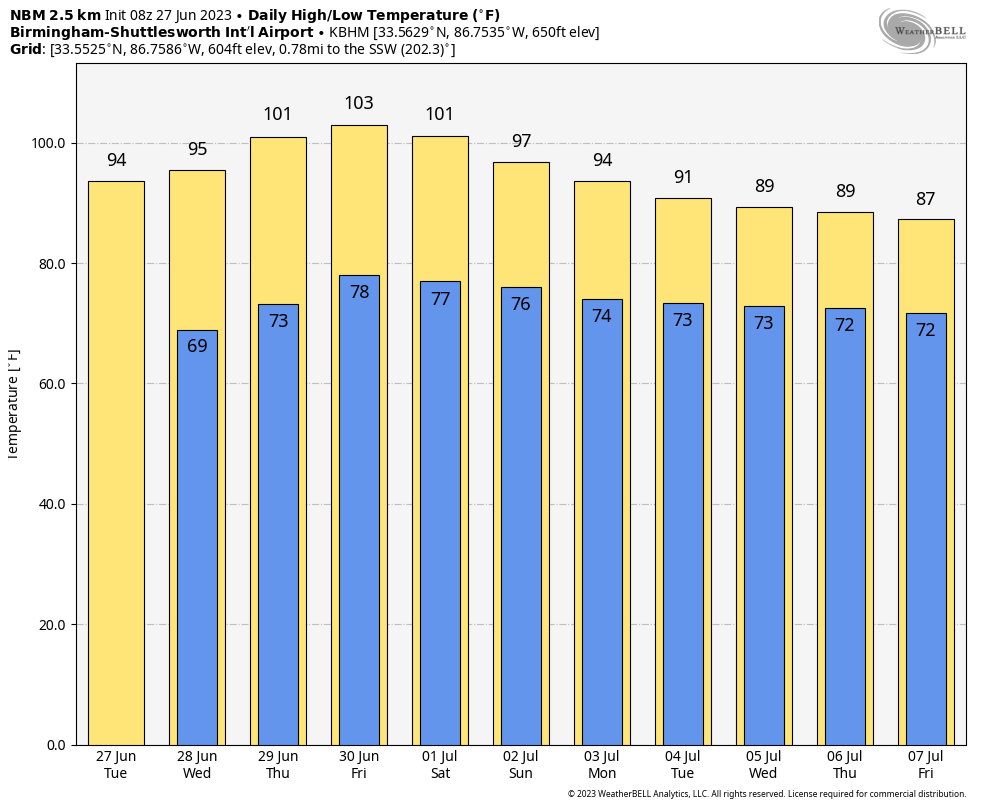
HOT: The hottest weather so far this year is just around the corner for Alabama and much of the Deep South. We are forecasting highs in the mid 90s today and tomorrow, upper 90s Thursday, and very close to 100 degrees Friday. Humidity levels will creep up as well, and by Thursday and Friday the heat index could rise to near 110 degrees over the western half of the state. There is an “excessive heat watch” in effect for the areas along and west of I-65. The heat index for eastern counties could reach 105 on these days.
Today will feature a sunny sky; we can’t rule out a few isolated pop-up thunderstorms during the afternoon and evening hours tomorrow through Friday, but the odds of any one spot seeing a cooling shower are only in the 10-20 percent range. Keep in mind where storms do form on very hot afternoons they tend to be very efficient lightning producers.
FOURTH OF JULY WEEKEND: The upper ridge will slowly weaken over the weekend and into next week, meaning heat levels will slowly come down. We expect highs in the mid 90s Saturday and Sunday, followed by low 90s Monday and Tuesday. Each day we will mention “scattered, mostly afternoon and evening showers and thunderstorms”, which is to be expected this time of the year. Afternoon storms will be totally random, and mostly between 2:00 and 9:00 p.m. Chance of any one location seeing a storm each day will be around 30-35 percent.
REST OF NEXT WEEK: Heat levels continue to fall; highs will be in the 86-90 degree range Wednesday through Friday with scattered showers and thunderstorms becoming more numerous as the ridge continues to weaken. See the video briefing for maps, graphics, and more details.
TROPICS: An area of low pressure, associated with the remnants of Tropical Storm Cindy, is producing disorganized showers and thunderstorms more than 400 miles to the south-southeast of Bermuda. While strong upper-level winds are expected to prevent redevelopment of this system over the next couple of days, environmental conditions could become marginally conducive for some gradual development during the latter part of this week. The system is forecast to move generally northward over the western Atlantic, passing near Bermuda on Thursday.
The rest of the Atlantic basin, including the Gulf of Mexico, will remain very quiet through early next week.
ON THIS DATE IN 1957: Audrey made landfall between Sabine Pass and Johnsons Bayou, Louisiana around 7:00a CT as a strong category three hurricane with maximum sustained winds of 125 mph and a minimum central pressure of 27.94 inches. Hurricane Audrey ranks as the 7th deadliest hurricane to strike the United States (3rd deadliest within Louisiana) in modern record keeping, with at least 500 deaths. The exact number will never be known, as many perished in the storm surge in Cameron and Vermilion parishes, and many missing persons were never found. Hurricane Audrey is also noted as being one of the strongest June hurricanes, and earliest major hurricane to make landfall across Louisiana, as well as the United States.
Look for the next video update here by 3:00 this afternoon… enjoy the day!
Category: Alabama's Weather, ALL POSTS, Weather Xtreme Videos
About the Author (Author Profile)
James Spann is one of the most recognized and trusted television meteorologists in the industry. He holds the AMS CCM designation and television seals from the AMS and NWA. He is a past winner of the Broadcast Meteorologist of the Year from both professional organizations.Subscribe
If you enjoyed this article, subscribe to receive more just like it.


