Hottest Weather So Far This Year Tomorrow/Friday
HAZY SUMMER SUN: Temperatures are mostly in the low 90s across Alabama this afternoon with a good supply of hazy sunshine. Mobile is the hot spot with 96 degrees at 2p CT; the heat index there is 104. Tonight will be mostly fair with a low in the 68-74 degree range.
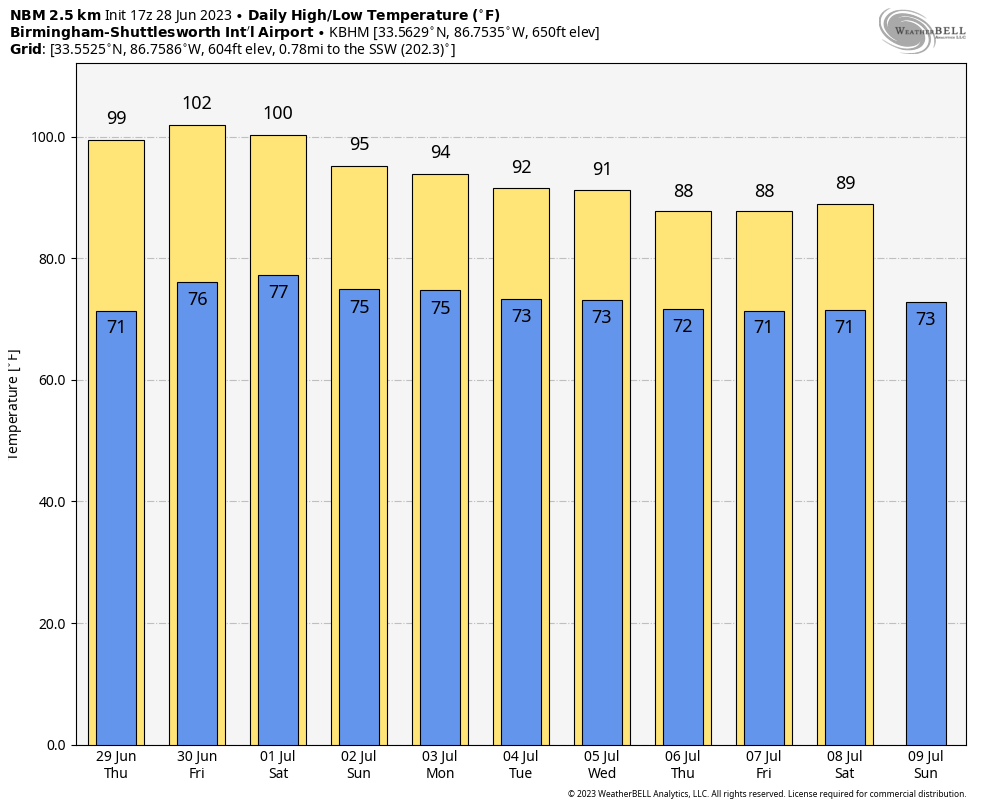
Heat levels will continue to rise across Alabama and the Deep South tomorrow and Friday with mostly sunny days and fair nights. Temperatures reach the upper 90s tomorrow, and the 97-101 degree range Friday afternoon. With high humidity values, the heat index will rise into the 105-110 degree range tomorrow and Friday, and excessive heat advisories and warnings will be needed for a decent part of Alabama.
Hot weather in Alabama is what we expect in summer, but with these heat levels those without air conditioning, and who work strenuous jobs outdoors can face the risk of heat exhaustion, or even heat stroke, which is serious. Use your common sense and stay cool as best you can.
There is always some risk of a pop up afternoon thunderstorm on hot summer days around here, but they should be few and far between through Friday.
FOURTH OF JULY WEEKEND: Heat levels will slowly come down Saturday through Tuesday. The high Saturday will be in the 93-97 degree range, followed by low to mid 90s Sunday. Then, the high Monday and Tuesday will be close to 90 degrees, which is slightly below average for early July. We will mention the chance of a few random, scattered showers and storms each day during the afternoon and evening hours… the chance of any one spot getting wet each day is around 30 percent.
REST OF NEXT WEEK: The heat ridge continues to weaken, and showers and storms will become more numerous over the latter half of the week with highs in the 87-91 degree range. See the video briefing for maps, graphics, and more details.
TROPICS: A surface trough is producing disorganized showers and thunderstorms a few hundred miles south-southeast of Bermuda. Upper-level winds are marginally conducive for some slow development of this system during the next few days while it moves generally northward at 5 to 10 mph. NHC gives the system only a 20 percent chance of development.
The rest of the Atlantic basin, including the Gulf of Mexico, is quiet, and tropical storm formation is not expected through early next week.
ON THIS DATE IN 1924: An estimated F4 tornado struck the towns of Sandusky and Lorain, Ohio, killing 85 people and injuring over 300. This tornado is the deadliest ever in Ohio history.
ON THIE DATE IN 1975: Lightning strikes Lee Trevino and two other golfers at the Western Open golf tournament in Oak Brook, Illinois.
Look for the next video update here by 6:00 a.m. tomorrow…
Category: Alabama's Weather, ALL POSTS, Weather Xtreme Videos
About the Author (Author Profile)
James Spann is one of the most recognized and trusted television meteorologists in the industry. He holds the AMS CCM designation and television seals from the AMS and NWA. He is a past winner of the Broadcast Meteorologist of the Year from both professional organizations.Subscribe
If you enjoyed this article, subscribe to receive more just like it.


