Midday Nowcast: Summer Sizzle with a Side of Strong Storms
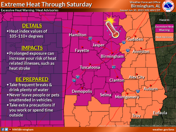
SCORCHING SUMMER HEAT: Upper 90s are pretty common on the maps this afternoon, and with high humidity levels, heat index values are in the 105°-115° range. Most of Alabama remains under an “excessive heat warning” or “heat advisory.”
Like yesterday, we are watching complexes of storms “the ring of fire,” tracking around the edge of the ridge. The SPC has defined a “slight risk” (level 2/5) of severe thunderstorms for parts of the Tennessee Valley, along with a “marginal risk” (level 1/5) down to Demopolis, Troy, and Eufaula.
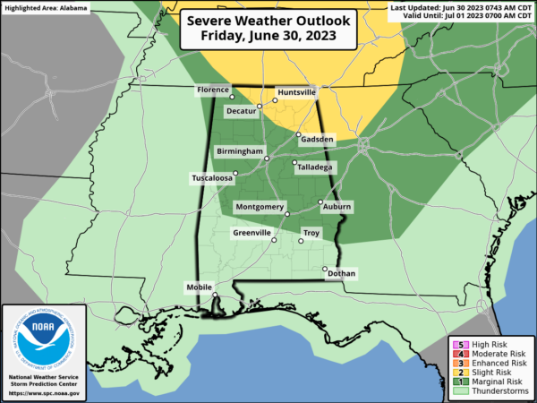
Main threats with these storms will be in damaging wind gusts and hail. We are keeping an eye on the radars to the north as storms track south towards Alabama…BIG HEAT, BIG STORMS, so if you find yourself under one of these storms, expect tremendous amounts of lightning and torrential rainfall.
Along with the heat, a Code Orange Air Quality Alert remains in effect for Jefferson and Shelby Counties. Under Code Orange conditions, ground level ozone concentrations are expected to reach levels that are unhealthy for sensitive groups.Children and people with asthma are individuals most at risk under these expected conditions.
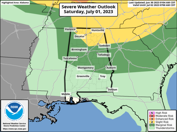
FOURTH OF JULY WEEKEND: We expect highs in the mid 90s Saturday and Sunday, followed by low 90s Monday and Tuesday. With higher moisture content, there will be a better chance for some afternoon showers and storms, but still, most locations will remain dry. Chance of any one location seeing a storm each day will be in 30-40% range. This is pretty typical Independence Day forecast across North/Central Alabama. We also note, the SPC again as defined the northern two thirds of Alabama under a risk of severe storms tomorrow as another MCS is possible.
REST OF NEXT WEEK: Higher rain chances and lower heat levels as highs will be closer to 90° Wednesday through Friday. Scattered showers and thunderstorms becoming more numerous as the ridge continues to weaken.
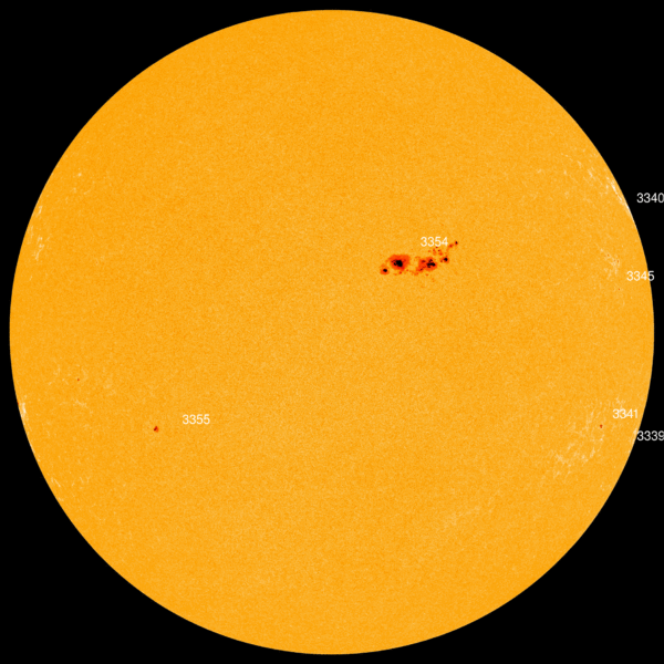
BIG SUNSPOT ALERT: One of the biggest sunspots in years is directly facing earth. R3354 is 10 times wider than Earth and about 1/3rd the size of the historical Carrington sunspot. It’s so big, observers in Europe and North America are seeing it naked-eye through the smoke of Canadian wildfires. Earth-directed flares are likely in the days ahead.
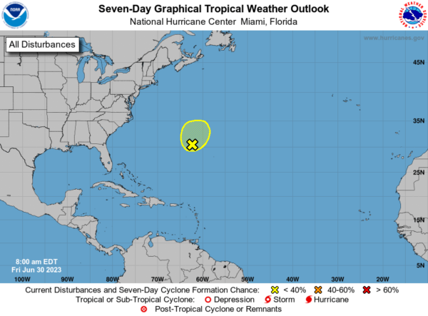
IN THE TROPICS: A broad area of low pressure is producing disorganized showers and thunderstorms a couple of hundred miles to the southeast of Bermuda. Upper-level winds do not appear conducive for this system to develop into a tropical or subtropical cyclone while it moves generally north-northeastward at about 10 mph during the next couple of days. Formation chance through 7 days…low…10 percent.
BEACH FORECAST CENTER: Get the latest weather and rip current forecasts for the beaches from Fort Morgan to Panama City on our Beach Forecast Center page. There, you can select the forecast of the region that you are interested in visiting.
WORLD TEMPERATURE EXTREMES: Over the last 24 hours, the highest observation outside the U.S. was 117.3F at Ahwaz, Iran. The lowest observation was -94.4F Vostok, Antarctica.
CONTIGUOUS TEMPERATURE EXTREMES: Over the last 24 hours, the highest observation was 114F at Death Valley, CA. The lowest observation was 29F at Sawmill Park, WY.
Category: Alabama's Weather, ALL POSTS
About the Author (Author Profile)
Macon, Georgia Television Chief Meteorologist, Birmingham native, and long time Contributor on AlabamaWX. Stormchaser. I did not choose Weather, it chose Me. College Football Fanatic. @Ryan_StinnetSubscribe
If you enjoyed this article, subscribe to receive more just like it.


