Heat Levels Rising; Mostly Dry Today
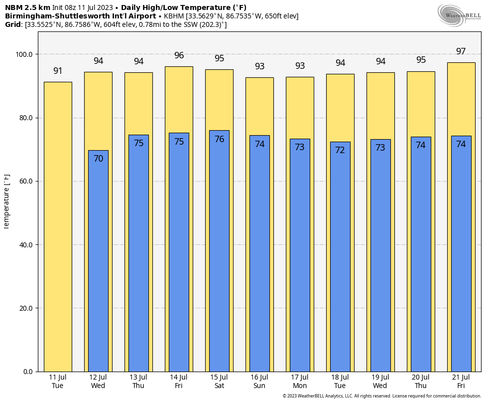
PLEASANT MORNING: Temperatures have dripped into the low to mid 60s across the cooler pockets of North Alabama this morning thanks to a drier airmass in place. Dewpoints are higher over the southern counties of the state, where we begin the day in the 70s. We expect a mostly sunny sky today with a high in the low 90s; showers and storms will be confined to the far South Alabama this afternoon.
Heat levels continue to rise tomorrow with most communities reaching the mid 90s; the sky will be partly to mostly sunny with a few isolated storms possible over the western and southern counties… but most places will stay dry.
THURSDAY THROUGH THE WEEKEND: We expect very routine summer weather… partly sunny, hot, humid days with random, scattered, mostly afternoon and evening showers and thunderstorms daily. Most of the storms will come in the 2:00-9:00 p.m. window, and the chance of any one spot getting wet daily is 40-50 percent. Afternoon highs will be in the low to mid 90s.
NEXT WEEK: We will stick with a persistence forecast as the classic summer pattern continues. A nasty heat ridge will be focused well to the west of Alabama; here will be in the 90-95 degree range most days with the usual risk of a pop-up thunderstorm during the afternoon and evening hours in random places. See the video briefing for maps, graphics, and more details.
TROPICS: An area of disorganized showers and thunderstorms is currently located a few hundred miles to the east-northeast of Bermuda. An area of low pressure is forecast to develop from this area in the next day or so, and environmental conditions are then forecast to be marginally conducive for further development. A subtropical or tropical depression could form during the latter part of this week as the system moves generally eastward. By the weekend, the low should turn northward bringing the system over cooler waters, likely limiting additional development. This feature is far from land, and NHC gives it a 50 percent chance of development over the next seven days.
The rest of the Atlantic basin remains very quiet; no tropical systems are expected be anywhere near the U.S. or the Gulf of Mexico through the weekend.
ON THIS DATE IN 1936: From July 5-17, temperatures exceeding 111 degrees in Manitoba and Ontario claimed 1,180 lives (mostly the elderly and infants) during the most prolonged, deadliest heat wave on record. Four hundred of these deaths were caused by people who drowned seeking refuge from the heat. In fact, the heat was so intense that steel rail lines and bridge girders twisted, sidewalks buckled, crops wilted and fruit baked on trees.
ON THIS DATE IN 1990: The costliest hailstorm in U.S. history occurred along the Front Range of the Colorado Rockies. (Denver, Colorado): Softball-sized hail destroyed roofs and cars, causing more than $600 million in total damage.
Look for the next video briefing here by 3:00 this afternoon… enjoy the day!
Category: Alabama's Weather, ALL POSTS, Weather Xtreme Videos
About the Author (Author Profile)
James Spann is one of the most recognized and trusted television meteorologists in the industry. He holds the AMS CCM designation and television seals from the AMS and NWA. He is a past winner of the Broadcast Meteorologist of the Year from both professional organizations.Subscribe
If you enjoyed this article, subscribe to receive more just like it.


