

Another Hot, Hazy Day; A Few Storms For North Alabama This Evening
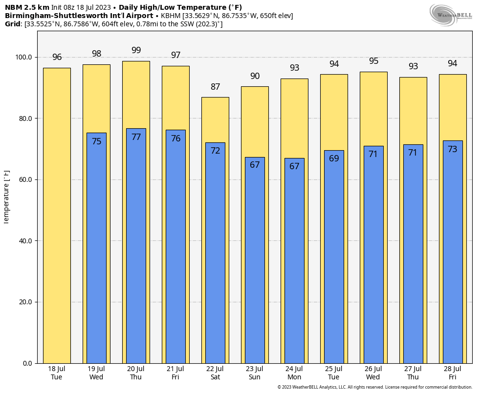
HOT SUMMER DAYS: We expect a high in the 92-97 degree range across Alabama today with sunshine filtered by smoke from Canadian wildfires in the higher levels of the atmosphere, and the usual summer particulates near the surface. High resolution model data suggests an MCS (Mesoscale Convective System) could creep into North Alabama early tonight. SPC has defined a “marginal risk” (level 1/5) of severe thunderstorms as far south as Tuscaloosa, Pelham, and Wedowee…
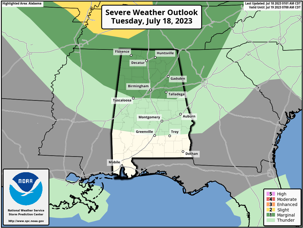
It is a safe bet the storms reach areas north of the Tennessee River this evening, but they will fade quickly later tonight, and I would suggest there is just an outside risk of them reaching areas as far south as I-20. The main concern with the heavier storms is strong winds.
REST OF THE WEEK: Some high-res models suggest potential for another batch of showers or storms tomorrow morning across the northeast corner of Alabama, but the weather will be generally hot and dry tomorrow and Thursday with highs in the mid to upper 90s. The Canadian wildfire smoke in the upper atmosphere will disperse late tonight and tomorrow. The day Friday looks generally dry with temperatures in the 90s again by afternoon, but an approaching surface boundary will bring showers and storms into the state late in the day and into Friday night.
THE ALABAMA WEEKEND: Models are a bit slower with the progression of the front, and showers and storms remain possible Saturday over the southern 2/3 of the state. Then, on Sunday, unusually dry air for summer will cover much of Alabama with a mostly sunny sky and lower humidity. Heat levels will come down with highs in the 85-90 degree range for the northern counties… low 90s are likely to the south. Any storms on Sunday should be confined to areas near the coast, and even there they should be pretty widely spaced.
NEXT WEEK: For now the week looks fairly quiet with mostly sunny days and only widely scattered afternoon showers or storms… highs will be in the 91-95 degree range, which is pretty much what we expect in late July in Alabama. See the video briefing for maps, graphics, and more details.
TROPICS: Tropical Storm Don is in the middle of the Atlantic, far from land, with winds of only 40 mph. It will loop around in the same are for the next 5-7 days and it is no threat to land. The rest of the Atlantic basin, including the Gulf of Mexico, is very quiet.
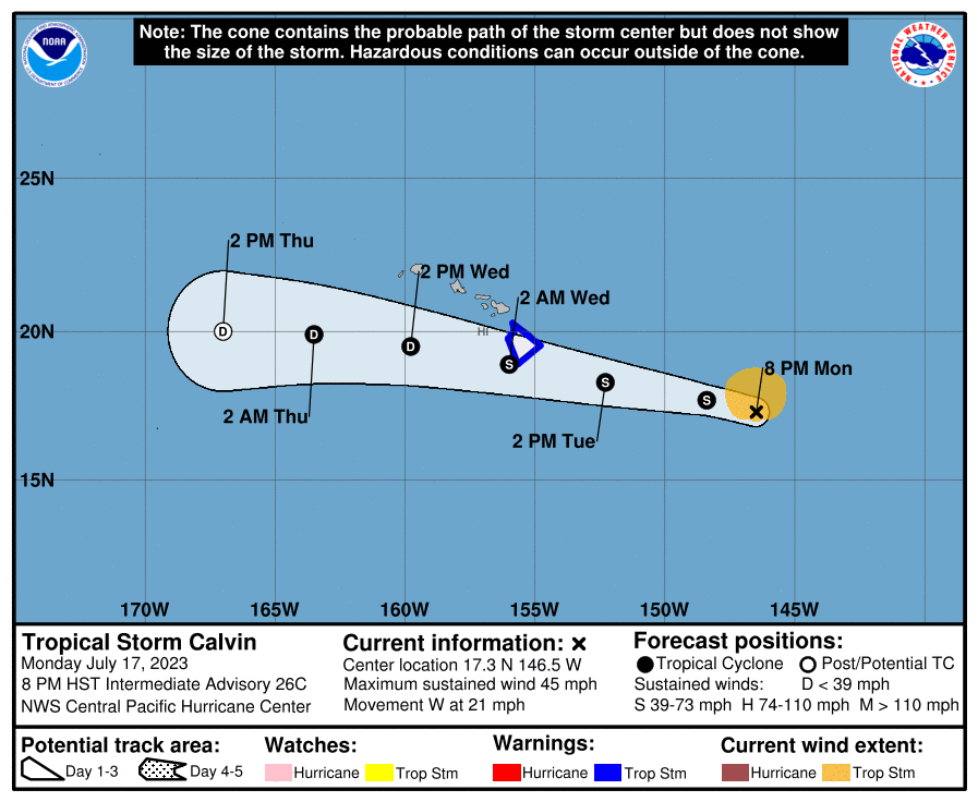
We do note over in the Pacific Tropical Storm Calvin is forecast to move over the Big Island of Hawaii late tonight; it a weak system with winds of 45 mph, but it will bring the threat of heavy rain.
ON THIS DATE IN 1996: A massive rainstorm in north central and northeast Illinois led to widespread flooding. Aurora reported 16.94 inches of rain, establishing a state record for the most rain in a single day. Other heavy totals included 13.60 inches at Joliet, 9.24 inches in Wheaton, 8.09 inches in DeKalb, and 7.82 inches at Elgin. This event is often called “the second most damaging weather disaster in Illinois History.”
Look for the next video briefing here by 3:00 this afternoon… enjoy the day!
Category: Alabama's Weather, ALL POSTS, Weather Xtreme Videos
About the Author (Author Profile)
James Spann is one of the most recognized and trusted television meteorologists in the industry. He holds the AMS CCM designation and television seals from the AMS and NWA. He is a past winner of the Broadcast Meteorologist of the Year from both professional organizations.Subscribe
If you enjoyed this article, subscribe to receive more just like it.


