Monday Weather Briefing Video — Less Humid & More Comfortable Air in Place for Much of Central Alabama
Spann is out on vacation this week, so only one video will be recorded and released each day as we’ll be on a vacation schedule.
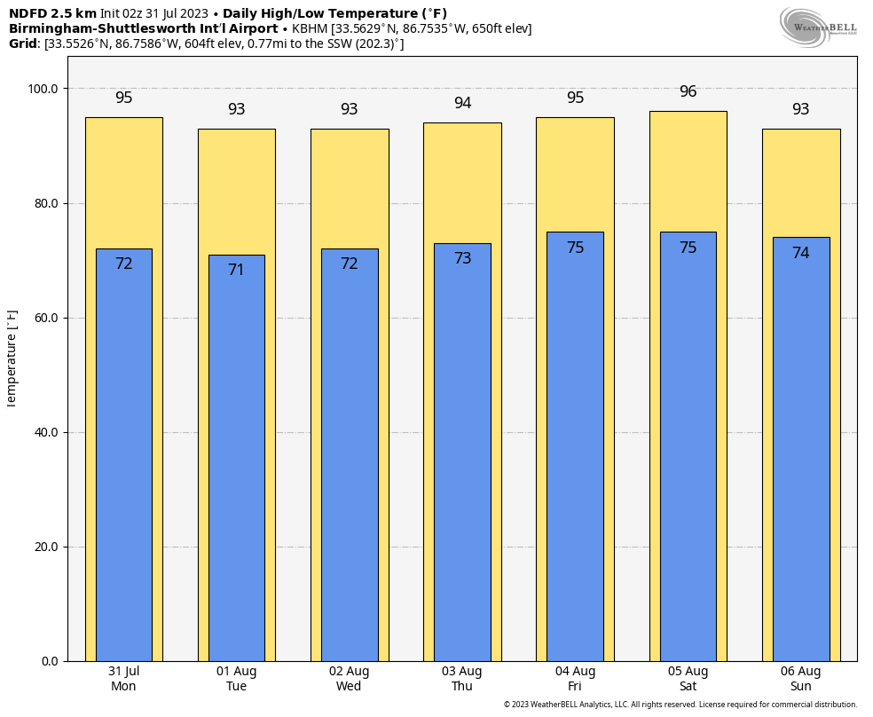
The Last Day of July
The boundary that moved through the area on Sunday will be over the southern portions of the area on Monday, keeping any rain chances south of a line from Tuscaloosa to Montgomery to Eufaula during the main heating of the day, where more unstable and humid air remains. North of those locations, the day will be dry with less humid air, so it will feel a little more comfortable. But, as you will see, it won’t last long. Highs throughout the 90s.
Just in case you wanted to know, Monday is…
• National Avocado Day
• World Ranger Day
• National Raspberry Cake Day
• Uncommon Instrument Awareness Day
Transitioning Over to August
A northwesterly flow will be in control of our weather pattern for one more day, which will keep humidity levels lower and our heat index values near or below 100º. Tuesday will be mainly dry, but models are trending with an MCV potentially moving into the area either very late on Monday night or into the early morning hours on Tuesday. Very little rainfall is expected as our drier airmass will help dissipate the moisture. However, the leftover boundary may spark a few isolated showers and storms during the afternoon. Highs will be in the mid 80s to the upper 90s from north to south.
Our flow changes from out of the south and southwest on Wednesday and through the end of the work week, which will bring an increase in humidity levels, scattered afternoon shower and storm chances, and chances of us sweating immediately after walking outside. Wednesday will be mostly sunny with a few isolated showers and storms possible, with highs in the upper 80s to the mid 90s. More humidity on Thursday means more instability during the afternoon, and scattered showers and storms will be possible. Highs in the lower to mid 90s. A good chance of scattered afternoon showers and storms will be possible on Friday, with highs throughout the 90s.
The First Weekend of August 2023
Not much change expected for the weekend as a few impulses are progged to move through the area, bringing with them a good chance of scattered showers and storms, mainly during the afternoon to evening hours on both days. Heat and humidity levels remain elevated as highs will be throughout the 90s on Saturday, and in the upper 80s to the mid 90s on Sunday.
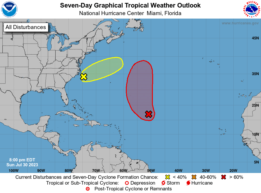
The Tropics (7pm Sunday Evening Update)
There are currently no depressions, tropical storms, or hurricanes out there in the tropical waters, but we do have two areas of interest that really do not pose any threat to land. Invest 96L has an 80% chance of becoming a tropical cyclone over the next seven days as it moves into slightly more conducive conditions for development. It will stay out over the Central Atlantic. Invest 97L is located just offshore of North Carolina and is starting to show signs of becoming organized. It may become a depression for a very short time period until it merges with a frontal boundary during the first part of the week and moves farther out over the Atlantic. Rough seas, gusty winds, and dangerous rip currents can be expected until the system moves farther away from the shore.
On This Day In Weather History
1987 – The deadliest tornado in 75 years struck Edmonton, Alberta, killing 26 persons and injuring 200 others. The twister caused more than 75 million dollars damage along its nineteen-mile path, leaving 400 families homeless. At the Evergreen Mobile Home Park, up to 200 of the 720 homes were flattened by the tornado.
Category: Alabama's Weather, ALL POSTS, Tropical, Weather Xtreme Videos
About the Author (Author Profile)
Scott Martin is an operational meteorologist, professional graphic artist, musician, husband, and father. Not only is Scott a member of the National Weather Association, but he is also the Central Alabama Chapter of the NWA president. Scott is also the co-founder of Racecast Weather, which provides forecasts for many racing series across the USA. He also supplies forecasts for the BassMaster Elite Series events including the BassMaster Classic.Subscribe
If you enjoyed this article, subscribe to receive more just like it.


