Thursday’s Weather Briefing — Some Potential for Strong/Severe Storms by Afternoon
Wednesday’s Highs Across Central Alabama
98 – Troy
96 – Montgomery
95 – Tuscaloosa
94 – Shelby Co. Airport
93 – Birmingham
92 – Anniston
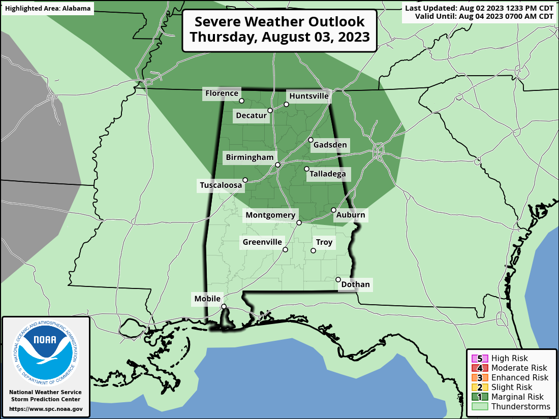
A Few Strong Storms Possible Today
Unfortunately, the stretch of decent late summer weather looks to be coming to an end as the ridge will retreat westward. Along with that, humidity levels will be rising, and mix that with a little bit of wind shear, a few strong to potentially severe storms may result when rain and storms develop north and northwest of us and move into the area during the late morning through the afternoon hours. The SPC has much of Central Alabama in a Marginal Risk for severe storms as far south as a line from Aliceville to Selma to Montgomery to Phenix City. Damaging winds and quarter-size hail will be the main threats during the afternoon and evening hours. Highs in the lower to mid 90s.
Just in case you wanted to know, Thursday is also known as…
• India Pale Ale Day
• National Watermelon Day
• Cloves Syndrome Awareness Day
• Clean Your Floor Day
• National Grab Some Nuts Day
More Storms on Friday
A few weak shortwaves will move through the area on Friday that will set the stage for a good chance of scattered showers and storms mainly during the afternoon and evening hours. At this point, we can’t rule out a few strong storms, but severe weather is not likely at this point. It will be hot and humid, with highs in the upper 80s to the mid 90s.
The First Weekend of August 2023
More weak waves will move through Central Alabama this weekend that will keep scattered showers and storms at times, especially during the afternoon and evening hours. Saturday looks to have more storm activity firing off during the main heating of the day. Highs in the lower to mid 90s.
Sunday will feature a little more sunshine and staying dry during the morning. By the time we reach the afternoon, scattered showers and storms will fire up across the area. Highs in the lower to mid 90s.
How Does Monday Through Wednesday Look?
A cold front will be heading in our direction on Monday and will eventually stall out over the extreme northern parts of the state that will allow for more moisture to be advected into the area and increase the instability rates to fire off storms and allow them to last a good while. We may see some stronger storms if we can get even more energy down into the area. Highs in the upper 80s to the mid 90s.
We’ll keep the same forecast going for Tuesday as the front will get a push southward and will slowly make its way through Central Alabama. Scattered showers and storms will continue to be possible throughout the day, and we can’t count out a few strong storms. Highs in the mid 80s to the lower 90s.
And at the end of the forecast period on Wednesday… A few storms may be left over from the front during the pre-dawn hours on Wednesday, but by sunrise, all of Central Alabama looks to be dry. However, a few isolated to scattered showers and storms look to be possible during the afternoon to the early evening hours. Highs in the mid 80s to the lower 90s.
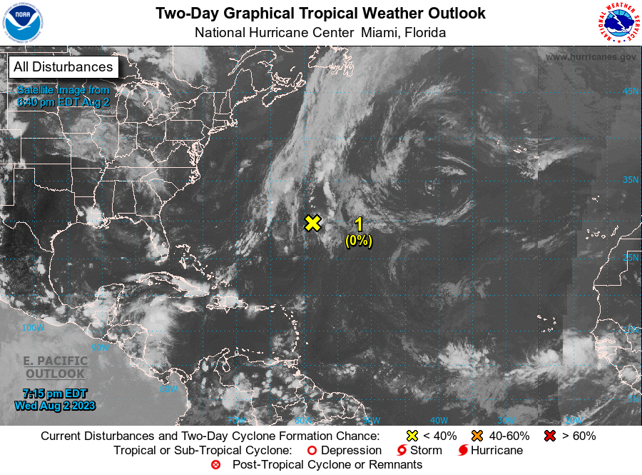
The Tropics (7pm Wednesday Evening Update)
Central Subtropical Atlantic (Invest 96): A trough of low pressure located a few hundred miles east-southeast of Bermuda has become less organized since yesterday. Development of this system is not anticipated due to strong upper-level winds. The trough is expected to move northward and merge with a frontal system over the north-central Atlantic during the next day or so.
* Formation chance through 48 hours…low…near 0 percent.
* Formation chance through 7 days…low…near 0 percent.
On This Day In Weather History
1970 – Hurricane Celia, one of the most vicious hurricanes in Texas history, made landfall near Port Aransas. Corpus Christi received the full brunt of the storm as sustained winds of 125 mph with a peak gust to 161 mph caused severe damage in the city. At Aransas Pass, wind gusts were estimated at 180 mph. 8950 homes were destroyed on the coastal bend. The pressure dropped to 945 millibars (27.89 inches) at Ingleside. Even at Del Rio, over 250 miles inland, a weakening Celia produced a wind gust to 89 mph. 11 people lost their lives and 466 were injured. Total damage was $454 million.
Beach Forecast Center
Get the latest weather and rip current forecasts for the beaches from Dauphin Island, AL, to Panama City Beach, FL, on our Beach Forecast Center page. There, you can select the forecast of the region that you are interested in.
E-Forecast
Get the Alabama Wx Weather Blog’s Seven-Day Forecast delivered directly to your inbox by email twice daily. It is the most detailed weather forecast available in Central Alabama. Subscribe here… It’s free!
WeatherBrains
If you are crazy about weather, this is THE podcast for you! Listen to the latest released episode each Tuesday, or catch up on any episodes that you have missed. The WeatherBrains crew includes your host, James Spann, plus other notable geeks like Troy Kimmel, Bill Murray, Rick Smith, James Aydelott, Jen Narramore, Dr. Neil Jacobs, and Dr. Kim Klockow-McClain. They bring together a wealth of weather knowledge and experience for another fascinating podcast about weather. Available at WeatherBrains.com, or on Apple Podcasts, Google Podcasts, Spotify, or Stitcher.
Category: Alabama's Weather, ALL POSTS, Severe Weather, Weather Xtreme Videos
About the Author (Author Profile)
Scott Martin is an operational meteorologist, professional graphic artist, musician, husband, and father. Not only is Scott a member of the National Weather Association, but he is also the Central Alabama Chapter of the NWA president. Scott is also the co-founder of Racecast Weather, which provides forecasts for many racing series across the USA. He also supplies forecasts for the BassMaster Elite Series events including the BassMaster Classic.Subscribe
If you enjoyed this article, subscribe to receive more just like it.


