Midday Nowcast: More Rain and Strong Storms
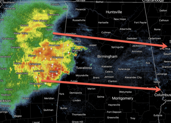
MORE SEVERE STORMS: The SPC maintains a “slight risk” (level 2/5) of severe storms today across much of Central and South Alabama, south of a line from Tuscaloosa to Jemison to Alexander City, while a “marginal risk” (level 1/5) extends as far north as Fayette to Birmingham to Anniston.
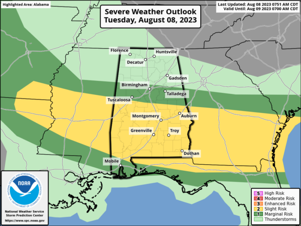
Like recent days, the main issue is damaging straight line winds, that can bring down thousands of trees and cause serious power outage issues. The core risk of severe thunderstorms is ongoing, and should be done and out of here by 5PM. We encourage you to pay attention to severe thunderstorm warnings since a number of them will likely be needed.
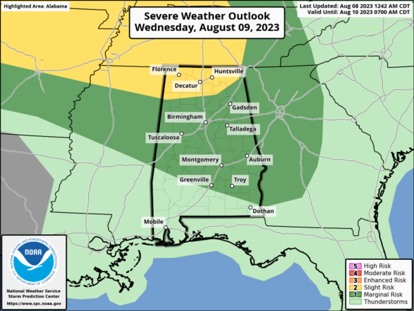
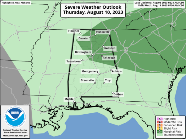
MORE SEVERE STORMS AHEAD: Tomorrow and Thursday, we are still going to be dealing with more strong to severe storms. The SPC has defined level 1/2 risks for parts of the state both days. Most, but not all of the showers and storms will come in the noon to midnight window. The chance of any one spot seeing rain both days is 50-60 percent range.
FRIDAY AND BEYOND: For now it looks like some typical August weather for the state with a mix of sun and clouds daily along with “scattered, mostly afternoon and evening showers and thunderstorms”; rain chances will be in the 40-50 percent range daily. Highs will be right at seasonal averages, in the low to mid 90s. This overall pattern looks to persist through the weekend and into next week.
IN THE TROPICS: All is quiet and no tropical cyclone development is expected through the upcoming weekend.
BEACH FORECAST CENTER: Get the latest weather and rip current forecasts for the beaches from Fort Morgan to Panama City on our Beach Forecast Center page. There, you can select the forecast of the region that you are interested in visiting.
WORLD TEMPERATURE EXTREMES: Over the last 24 hours, the highest observation outside the U.S. was 121.1F at Khanaqin, Iraq. The lowest observation was -107.1F Vostok, Antarctica.
CONTIGUOUS TEMPERATURE EXTREMES: Over the last 24 hours, the highest observation was 117F at Death Valley, CA. The lowest observation was 30F at Bryce Canyon, UT.
Category: Alabama's Weather, ALL POSTS
About the Author (Author Profile)
Macon, Georgia Television Chief Meteorologist, Birmingham native, and long time Contributor on AlabamaWX. Stormchaser. I did not choose Weather, it chose Me. College Football Fanatic. @Ryan_StinnetSubscribe
If you enjoyed this article, subscribe to receive more just like it.


