Lower Heat Levels Tomorrow Through Thursday
SIZZLING SUMMER DAY: Temperatures are in the 93-99 degree range across Alabama this afternoon with lots of hazy sunshine. We do note a few isolated storms have popped up, and thunderstorms are possible late day and tonight over the northern quarter of the state ahead of a surface front. SPC has the northeast corner of the state in a “slight risk” (level 2/5) of severe thunderstorms, with “marginal risk” (level 1/5) down to Hackleburg, Hanceville, and Spring Garden.
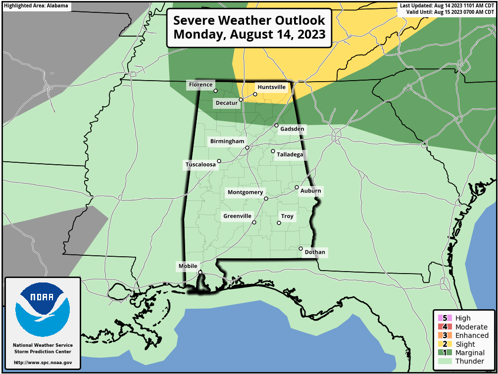
Storms tonight over North Alabama could produce strong winds, along with heavy rain and lots of lightning.
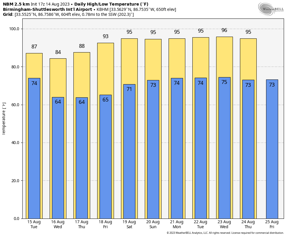
REST OF THE WEEK: The surface front will push through Alabama tomorrow, and scattered storms remain possible mainly for the southern 2/3 of the state south of the front. An airmass change begins over North Alabama with highs dropping into the mid to upper 80s. South Alabama remains hot and humid with highs in the 90s.
Dry, continental air pushes deep into the state by Wednesday. Humidity levels will be lower, highs will be under 90 over the northern half of the state, and we start the day with lows in the 60-65 degree range across the northern and central counties. Some of the cooler spots might even reach the upper 50s for a touch of fall. And, because of the dry air we won’t have to deal with summer storms, with the exception of areas near the Gulf Coast.
Dry weather will continue to be the story for most of the state Thursday through the weekend; any scattered storms will be confined to the far southern counties of Alabama. Heat levels rise, and by the weekend all of the state will see highs back in the mid 90s with humidity levels creeping up as well.
NEXT WEEK: A large scale upper high will bring hot and mostly dry weather to the Deep South with only isolated afternoon storms. Highs will be well into the 90s… See the video briefing for maps, graphics, and more details.
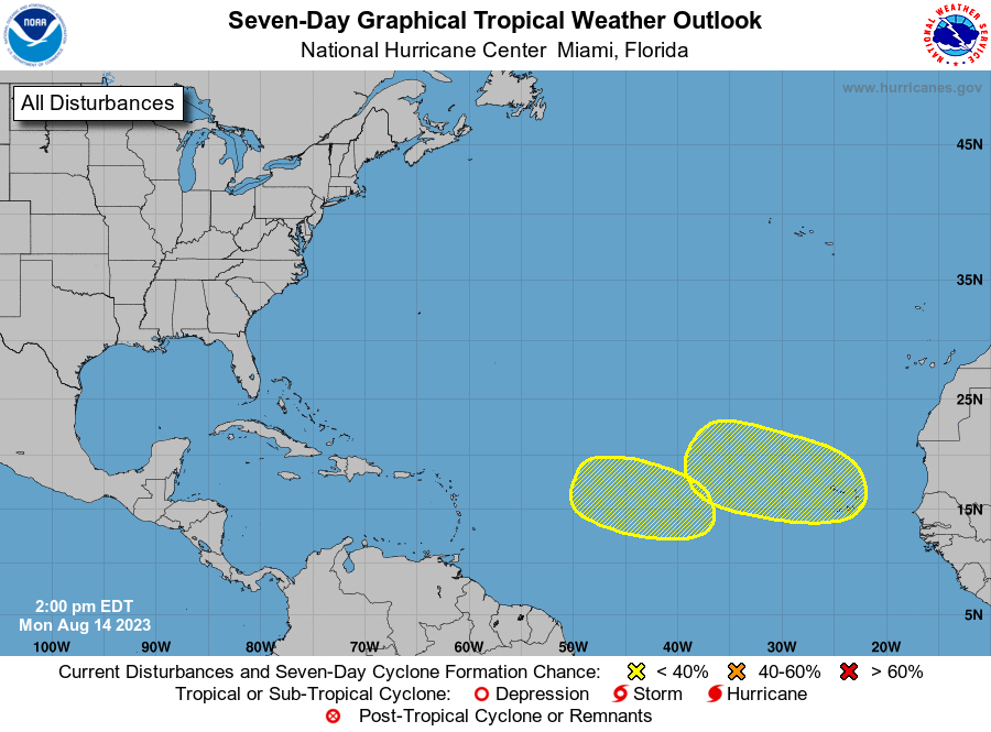
TROPICS: All remains quiet this morning, but NHC has identified two waves in the eastern Atlantic in 4-7 days. For now these have only a low chance (20 percent) of development… no tropical storms or hurricanes are expected near the U.S. or the Gulf of Mexico for at least the next seven days.
ON THIS DATE IN 1953: Barbara hits North Carolina as a Category 2 hurricane. Damage from the storm was relatively minor, totaling around $1.3 million (1953 USD). Most of it occurred in North Carolina and Virginia from crop damage. The hurricane left several injuries, some traffic accidents, as well as seven fatalities in the eastern United States; at least two were due to electrocution from downed power lines.
ON THIS DATE IN 1969: Hurricane Camille, a powerful, deadly, and destructive hurricane formed just west of the Cayman Islands on this day. It rapidly intensified, and by the time it reached western Cuba the next day, it was a Category 3 hurricane. Hurricane Camille was spawned on August 5th by a tropical wave off the coast of Africa. The storm became a tropical disturbance four days later on the 9th and a tropical storm on the 14th with a 999-millibar pressure center and 55 mph surface winds.
Look for the next video briefing here by 6:00 a.m. tomorrow…
Category: Alabama's Weather, ALL POSTS, Weather Xtreme Videos
About the Author (Author Profile)
James Spann is one of the most recognized and trusted television meteorologists in the industry. He holds the AMS CCM designation and television seals from the AMS and NWA. He is a past winner of the Broadcast Meteorologist of the Year from both professional organizations.Subscribe
If you enjoyed this article, subscribe to receive more just like it.


