Midday Nowcast: Very Hot August Weather
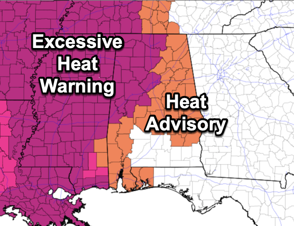
LITTLE CHANGE: It’s the same old song and dance…Blistering Late Summer Heat…as the strong upper high remains in place across the Mississippi Valley. Our weather remains mostly dry and very hot with highs across Alabama ranging from 95°-105°. Heat index value values are in the 105°-115° range, and an excessive heat warning and heat advisories are in effect today and tomorrow, and these will likely continue into the weekend. Rain chances are not zero, but generally less than 20%, due to the sinking air under the upper high. If you find yourself under any of these isolated showers or storms that pops up, consider yourself lucky, as they will be the only heat-relief.
WEEKEND WEATHER: The weather won’t change much Saturday with very hot and mainly dry conditions and highs in the upper 90s. Sunday, as the upper ridge weakens and shifts to the west, more showers and storms should develop across the Alabama landscape. Sunday’s high will be in the low to mid 90s.
FOOTBALL WEATHER: For the first week of high school football, it will be a very warm, humid night across Alabama tomorrow night. The sky will be clear with temperatures falling through the 80s during the game.
Saturday, Jacksonville State hosts the University of Texas at El Paso (4:30p CT kickoff) at Burgess-Snow Field; the sky will be mostly clear and the day will be very hot. Expect a kickoff temperature near 96 degrees, falling into the upper 80s by the final whistle.
NEXT WEEK: Rolling into the final week of August, highs will be in the 90s Monday, then look to drop into the upper 80s on Tuesday with scattered to perhaps widespread scattered showers and storms. A pattern change suggest that drier air and cooler air will settle into Alabama for the second half of the week, meaning lower humidity as well.
IN THE TROPICS: Tropical Storms Franklin is moving toward the north near 13 mph. A turn to the northeast and then east-northeast with a decrease in forward speed is forecast during the next couple of days. On the forecast track, the center of Franklin will continue to move farther away from the Dominican Republic and over the southwestern Atlantic into the weekend.
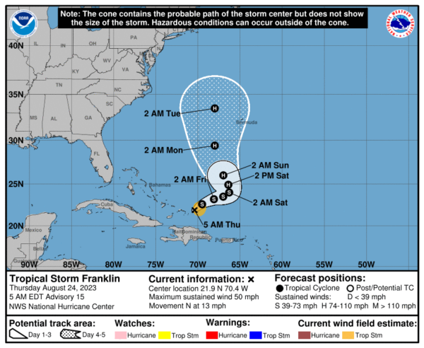
Maximum sustained winds are near 50 mph and gradual strengthening is forecast; Franklin is expected to become a hurricane in a couple of days. The estimated minimum central pressure is 1001 mb (29.56 inches). The system is not expected to impact the U.S. as it drifts northward between the East Coast and Bermuda.
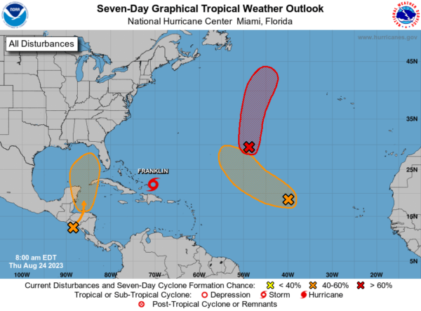
Trouble closer to home, a broad area of low pressure, originating along the East Pacific coast of Central America, is forecast to move into northwestern Caribbean Sea by this weekend. Some gradual development of this system is possible thereafter into early next week, and a tropical depression could form while it moves slowly northward, entering the eastern Gulf of Mexico. Formation chance through 48 hours…low…10 percent. Formation chance through 7 days…medium…50 percent.
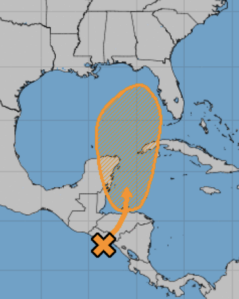
Of course we are keeping an eye on this feature as it will be in the Gulf, and way too early to know any specifics. However, most of the global models keep this system southeast of Alabama, likely impacting the Florida Peninsula.
Next several names up to use: Idalia, Jose, and Katia.
BEACH FORECAST CENTER: Get the latest weather and rip current forecasts for the beaches from Fort Morgan to Panama City on our Beach Forecast Center page. There, you can select the forecast of the region that you are interested in visiting.
WORLD TEMPERATURE EXTREMES: Over the last 24 hours, the highest observation outside the U.S. was 124.9F at Basrah-Husssen, Iraq. The lowest observation was -105.0F Concordia, Antarctica.
CONTIGUOUS TEMPERATURE EXTREMES: Over the last 24 hours, the highest observation was 109F at Gila Bend, AZ. The lowest observation was 30F at Polebridge, MT.
Category: Alabama's Weather, ALL POSTS
About the Author (Author Profile)
Macon, Georgia Television Chief Meteorologist, Birmingham native, and long time Contributor on AlabamaWX. Stormchaser. I did not choose Weather, it chose Me. College Football Fanatic. @Ryan_StinnetSubscribe
If you enjoyed this article, subscribe to receive more just like it.


