Heat Relief For Alabama Arrives Next Week
AUGUST HEAT: Temperatures are in the 95-100 degree range across most of Alabama at mid-afternoon with a partly to mostly sunny sky. We do note a few isolated storms over the northeast corner of the state; a few more could form over the next few hours, but most places will stay dry. The low tonight will be in the 70s.
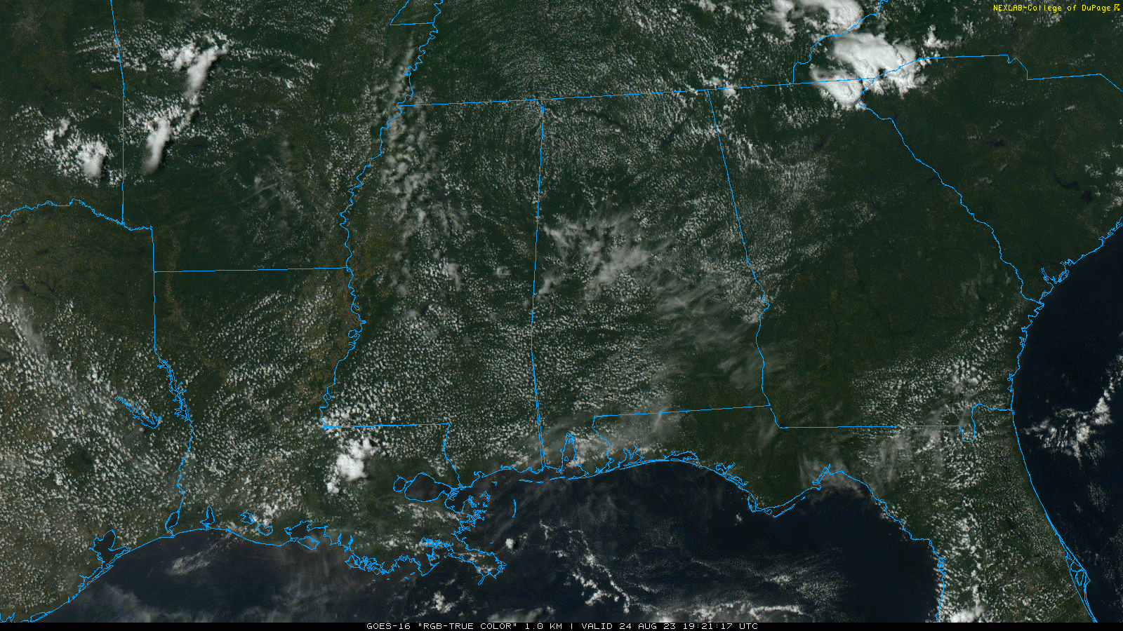
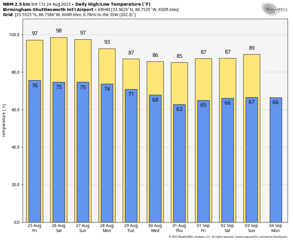
Alabama’s weather won’t change much through the weekend thanks to the large upper high in place. Daily highs will be in the 95-99 degree range for most communities, with heat index values exceeding 100 each day. We will maintain the chance of isolated showers and thunderstorms in the noon to midnight window daily as high resolution models suggest the air aloft will be a tad colder, and instability levels a bit higher. But, the chance of any one spot actually getting wet through Sunday is only 20-25 percent.
NEXT WEEK: The upper ridge breaks down and shifts westward. Accordingly, heat levels drop and scattered showers and storms will increase in coverage Monday and Tuesday. The high Monday will be close to 90, followed by mid to upper 80s Tuesday through Friday. Global models continue to hint at drier, continental air moving into the state by mid-week… if this happens lows could drop into the 50s over the northern half of the state by Thursday morning. See the video briefing for maps, graphics, and more details.
FOOTBALL WEATHER: For the first week of high school football, it will be a very warm, humid night across Alabama tomorrow night. An isolated storm can’t be totally ruled out, otherwise the sky will be mostly fair with temperatures falling through the 80s during the games.
Saturday, Jacksonville State hosts the University of Texas at El Paso (4:30p CT kickoff) at Burgess-Snow Field; the weather will be very hot with an outside risk of a brief shower or storm during the game. Expect a kickoff temperature near 96 degrees, falling into the upper 80s by the final whistle.
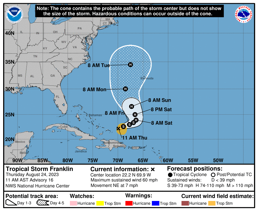
TROPICS: Tropical Storm Franklin is in the Atlantic, centered about 100 miles east/northeast of Grand Turk Island with winds of 60 mph. It is moving northeast at 7mph, and is forecast to become a hurricane over the weekend west of Bermuda. Franklin will remain east of the U.S.
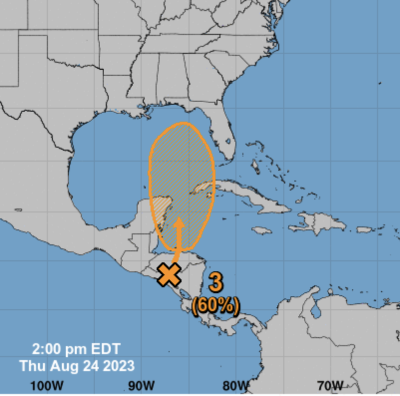
Closer to home, a broad area of low pressure centered over Central America is forecast to move into northwestern Caribbean Sea by this weekend. Some gradual development of this system is possible thereafter into early next week, and a tropical depression could form while it moves slowly northward, entering the eastern Gulf of Mexico. NHC gives the system a 60 percent chance of becoming a depression or storm within seven days.
It is way too early to know the intensity or specific track of this system, or the impact on Florida, but it is clearly something to watch over the next few days. If a tropical system does form, most global models suggest the impact will be southeast of Alabama next week.
NHC is also monitoring two other areas of interest in the tropical Atlantic, but those won’t impact any land areas.
ON THIS DATE IN 1992: Hurricane Andrew made landfall in southern Florida at 4:30 AM on this day. The high winds caused catastrophic damage in Florida, with Miami-Dade County cities of Florida City, Homestead, and Cutler Ridge receiving the brunt of the storm. About 63,000 homes were destroyed, and over 101,000 others were damaged. This storm left roughly 175,000 people homeless. As many as 1.4 million people were left without electricity at the height of the storm. 44 fatalities were reported in Florida.
Andrew is one of only four tropical cyclones to make landfall in the continental United States as a Category 5, alongside the 1935 Labor Day hurricane, 1969’s Camille, and 2018’s Michael. With a barometric pressure of 922 mb (27.23″) at the time of landfall in Florida, Andrew is the sixth most-intense hurricane to strike the United States.
Look for the next video briefing here by 6:00 a.m. tomorrow…
Category: Alabama's Weather, ALL POSTS, Weather Xtreme Videos
About the Author (Author Profile)
James Spann is one of the most recognized and trusted television meteorologists in the industry. He holds the AMS CCM designation and television seals from the AMS and NWA. He is a past winner of the Broadcast Meteorologist of the Year from both professional organizations.Subscribe
If you enjoyed this article, subscribe to receive more just like it.


