A Few Storms Around This Afternoon; Eyes On The Gulf
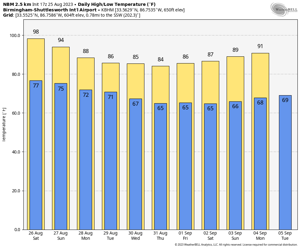
RADAR CHECK: At mid-afternoon we have a few widely scattered showers and storms on radar in the broad zone from Gordon and Reform to Tuscaloosa and Montgomery. They are moving to the southwest, and are producing brief heavy rain and gusty winds. A few additional storms could form through about 9:00 tonight in random spots. Away from these storms, it is another hot August afternoon with temperatures in the 94-100 degree range.

THE WEEKEND: Alabama’s weather won’t change much through the weekend as the hot August weather continues. We expect partly to mostly sunny days, fair nights, and a handful of isolated afternoon and evening showers and storms through Sunday. Chance of any one location seeing rain daily is around 20 percent, and most of the storms will come from about 2 until 9 p.m. Highs will hold in the mid to upper 90s tomorrow, with low to mid 90s Sunday.
NEXT WEEK: Heat levels fall, and scattered showers and thunderstorms become more numerous Monday and Tuesday with the approach of a surface front. Highs drop into the 80s over the northern half of the state, and low 90s over South Alabama. The weather over the latter half of the week will depend on the behavior of the tropical system in the Gulf, and there is great uncertainty in that forecast for now. See the video briefing for maps, graphics, and more details.
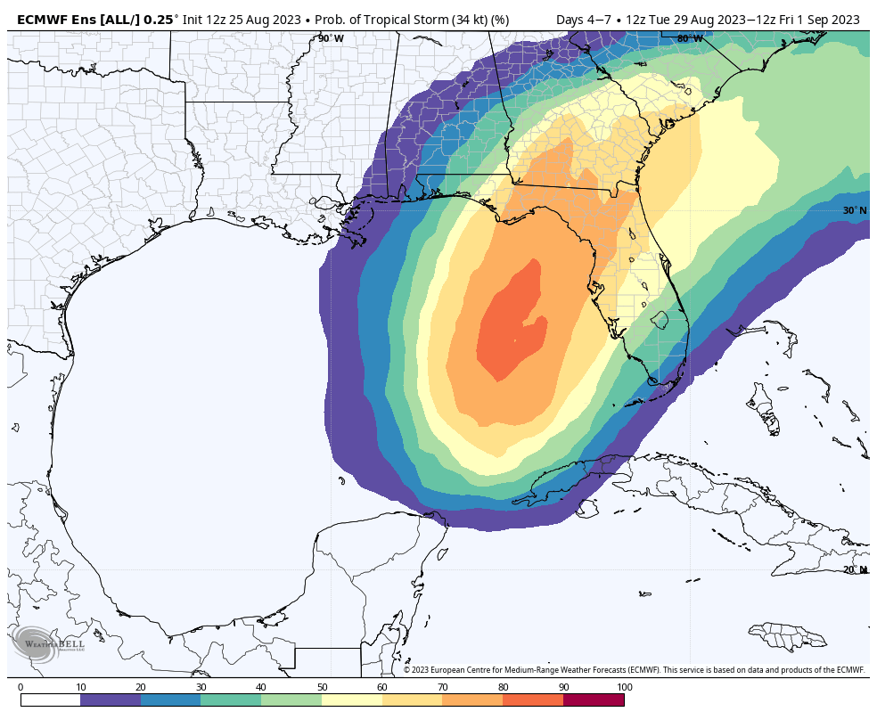
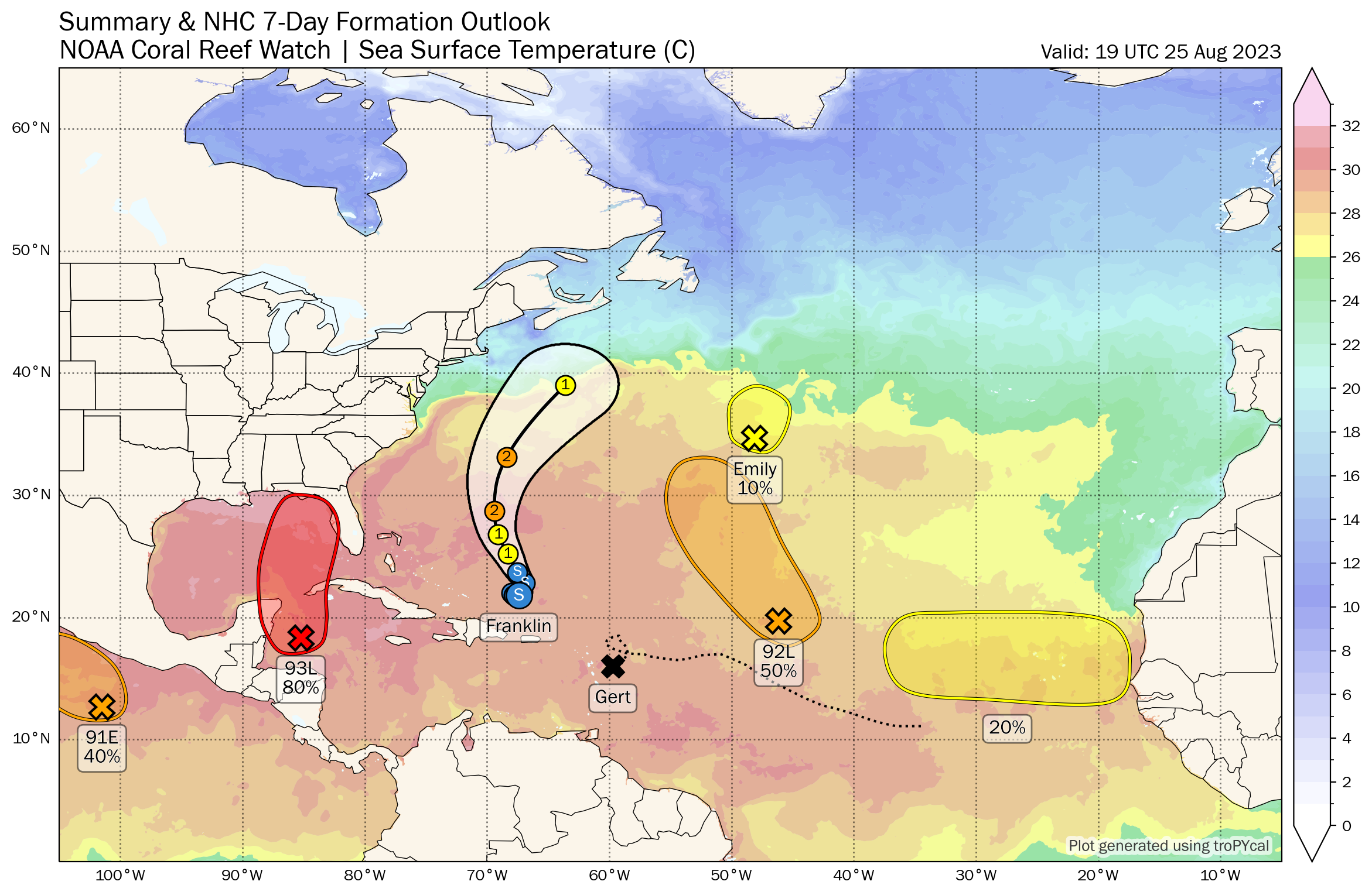
TROPICS: Satellite images indicate that the area of low pressure over the northwestern Caribbean Sea (Invest 93L) is gradually becoming better organized, with increasing thunderstorm activity and a better-defined low-level circulation. Environmental conditions appear conducive for further development during the next several days, and a tropical depression is likely to form late this weekend or early next week while it moves generally northward over the eastern Gulf of Mexico. Interests in the Yucatan Peninsula of Mexico, western Cuba, and Florida should monitor the progress of this system NHC now gives the system a 80 percent chance of development.
There is great uncertainty in the forecast track and intensity of this system. Models have generally trended westward over the past 12 hours, and ensemble output suggests the highest probability of landfall is now over the “Big Bend” area of Florida late Tuesday night or Wednesday of next week. But everyone from Pensacola to Fort Myers will need to be ready for a tropical system in 4-5 days. Once the system develops a low level center, and we get dropsonde data from Hurricane Hunter aircraft, a reliable forecast can be put together.
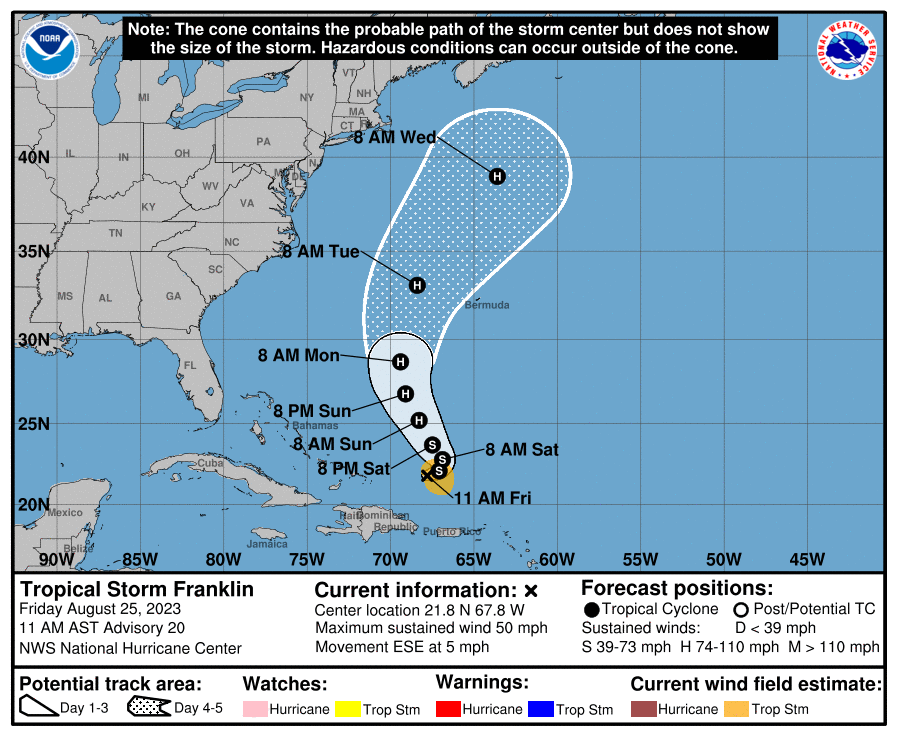
Elsewhere, Tropical Storm Franklin is about 750 miles south/southwest of Bermuda with winds of 50 mph. It is expected to become a hurricane over the weekend… it will pass west of Bermuda, and will remain well east of the U.S.
Other areas of interest across the Atlantic are expected to stay far from land.
FOOTBALL WEATHER: For the first week of high school football, tonight will be a very warm, humid night across Alabama. An isolated storm can’t be totally ruled out, otherwise the sky will be mostly fair with temperatures falling through the 80s during the games.
Tomorrow, Jacksonville State hosts the University of Texas at El Paso (4:30p CT kickoff) at Burgess-Snow Field; the weather will be very hot with an outside risk of a brief shower or storm during the game. Expect a kickoff temperature near 96 degrees, falling into the upper 80s by the final whistle.
ON THIS DATE IN 1814: In the early afternoon, a strong tornado struck northwest Washington D.C. and downtown. The severe tornadic storm arrived the day after the British Troops had set fire to the Capitol, the White House, and other public buildings. The storm’s rains would douse those flames. The tornado did major structural damage to the residential section of the city. The tornado’s flying debris killed more British soldiers than by the guns of the American resistance.
ON THIS DATE IN 2017: Hurricane Harvey made landfall on San Jose Island, Texas, as a Category 4 storm. It is tied with 2005’s Hurricane Katrina as the costliest tropical cyclone on record, inflicting $125 billion (2017 USD) in damage, primarily from catastrophic rainfall-triggered flooding in the Houston metropolitan area and Southeast Texas; this made the storm the costliest natural disaster recorded in Texas at the time. It was the first major hurricane to make landfall in the United States since Wilma in 2005, ending a record 12-year span in which no hurricanes made landfall at the intensity of a major hurricane throughout the country. In a four-day period, many areas received more than 40 inches of rain as the system slowly meandered over eastern Texas and adjacent waters, causing unprecedented flooding.
Look for my next video briefing here by 6:00 a.m. Monday… enjoy the weekend!
Category: Alabama's Weather, ALL POSTS, Weather Xtreme Videos
About the Author (Author Profile)
James Spann is one of the most recognized and trusted television meteorologists in the industry. He holds the AMS CCM designation and television seals from the AMS and NWA. He is a past winner of the Broadcast Meteorologist of the Year from both professional organizations.Subscribe
If you enjoyed this article, subscribe to receive more just like it.


