Late Evening Check on Idalia
The Hurricane Hunters are holding just off the west coast of Cuba where the center of Hurricane Idalia is located right now, waiting for it to clear land so they can resume center penetrations.
Here is the satellite imagery:
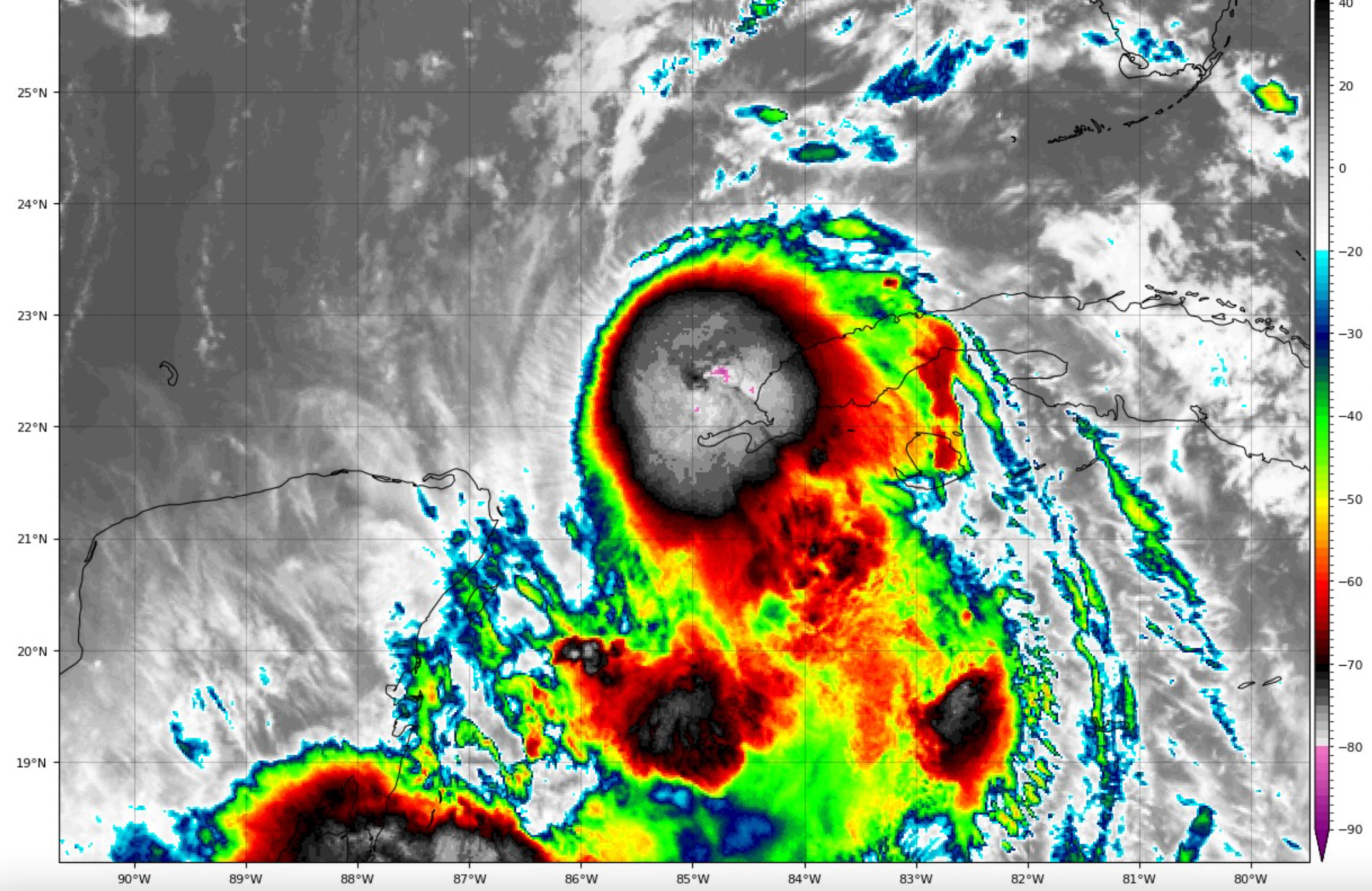
Idalia is still undergoing shear tonight and that has prevented its big bursts of convection from wrapping around the center. It still does not have well established outflow. But there are signs that the outflow is beginning to improve. The Cuban radars show a partial eyewall begining to form. Once that organization begins, intensification will be possible.
And conditions are expected to continue to change starting early tomorrow and a period of rapid intensification will begin.
It is expected that Idalia will be a strong category 3 hurricane when it makes landfall Wednesday morning in the Big Bend of Florida.
A devastating and deadly storm surge will affect the Nature Coast from the mouth of the Ancilla River to Chassahowitzka, FL. Here are all the projected storm surge values from the NHC Advisory:
Aucilla River, FL to Chassahowitzka, FL…8-12 ft
Chassahowitzka, FL to Anclote River, FL…6-9 ft
Ochlockonee River, FL to Aucilla River, FL…5-8 ft
Anclote River, FL to Middle of Longboat Key, FL…4-7 ft
Tampa Bay…4-7 ft
Middle of Longboat Key, FL to Englewood, FL…3-5 ft
Englewood, FL to Chokoloskee, FL…2-4 ft
Charlotte Harbor…2-4 ft
Indian Pass, FL to Ochlockonee River, FL…3-5 ft
Mouth of the St. Mary’s River to South Santee, SC…2-4 ft
Chokoloskee, FL to East Cape Sable, FL…1-3 ft
Flagler/Volusia County Line, FL to Mouth of St. Mary’s River…1-3
ft
Indian Pass to Mexico Beach…1 to 3 ft.
Florida Keys…1-2 ft
From the NHC discussion: Idalia is forecast to move into an area that is highly susceptible
to storm surge, and regardless of the cyclone’s specific landfall
intensity, there is increasing confidence that a significant storm
surge event will occur.
WIND
Hurricane conditions are expected within the hurricane warning area
in Florida by late Tuesday or Wednesday, with tropical storm
conditions beginning on Tuesday.
Tropical storm conditions are expected in the Dry Tortugas
beginning tonight and within the tropical storm warning area
along the Florida Gulf coast on Tuesday.
Tropical storm conditions are possible along the southeast U.S.
coast within the southern portions of the watch area by early
Wednesday.
RAINFALL
Portions of the west coast of Florida, the Florida Panhandle,
southeast Georgia and the eastern Carolinas: 4 to 8 inches from
Tuesday into Thursday. Isolated higher totals of 12 inches possible,
primarily near landfall in northern Florida.
This rainfall may lead to flash and urban flooding, and landslides
across western Cuba.
Areas of flash and urban flooding, some of which may be locally
significant, are expected across portions of the west coast of
Florida, the Florida Panhandle, and southern Georgia Tuesday into
Wednesday, spreading into portions of the eastern Carolinas
Wednesday into Thursday.
SURF: Swells generated by Idalia are affecting portions of the
southern coast of Cuba and eastern Yucatan. These swells will
spread northward along the eastern Gulf Coast during the next day
or two. These swells are likely to cause life-threatening surf and
rip current conditions. Please consult products from your local
weather office.
TORNADOES: A few tornadoes will be possible starting Tuesday along
the west-central Florida coast and the tornado threat will spread
northward into the Florida Big Bend area by Tuesday night.
I will give you one more update late tonight.
Then updates will resume around 11 a.m. tomorrow.
About the Author (Author Profile)
Bill Murray is the President of The Weather Factory. He is the site's official weather historian and a weekend forecaster. He also anchors the site's severe weather coverage. Bill Murray is the proud holder of National Weather Association Digital Seal #0001 @wxhistorianSubscribe
If you enjoyed this article, subscribe to receive more just like it.


