Idalia Nearing Landfall; Only Spotty Showers For Alabama Today
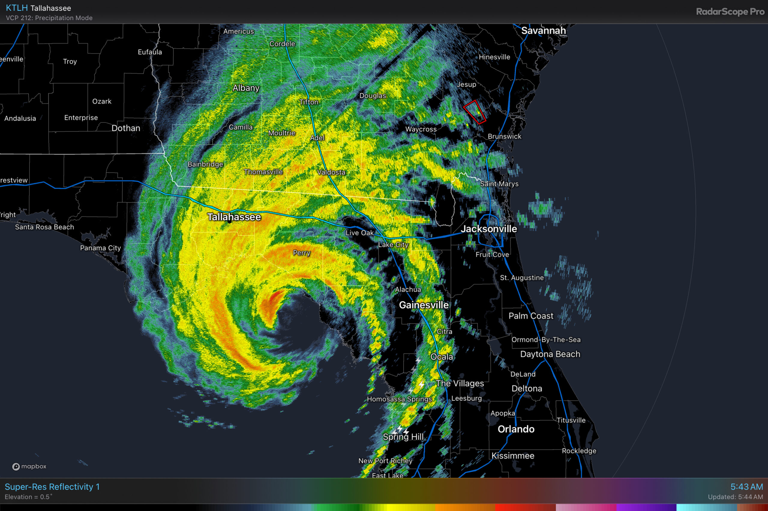
IDALIA STAYS TO THE EAST: We will mention the chance of a few spotty showers for Alabama later today, but the big rains in association with Hurricane Idalia will remain east of Alabama over North Florida, Georgia, and the Carolinas through tonight. Around here we expect a mix of sun and clouds with highs in the 80s over most of the state. It will be a breezy day for the southeast counties, where places like Dothan and Ozark could see a gust to 35/40 mph at times as Idalia passes to the east.
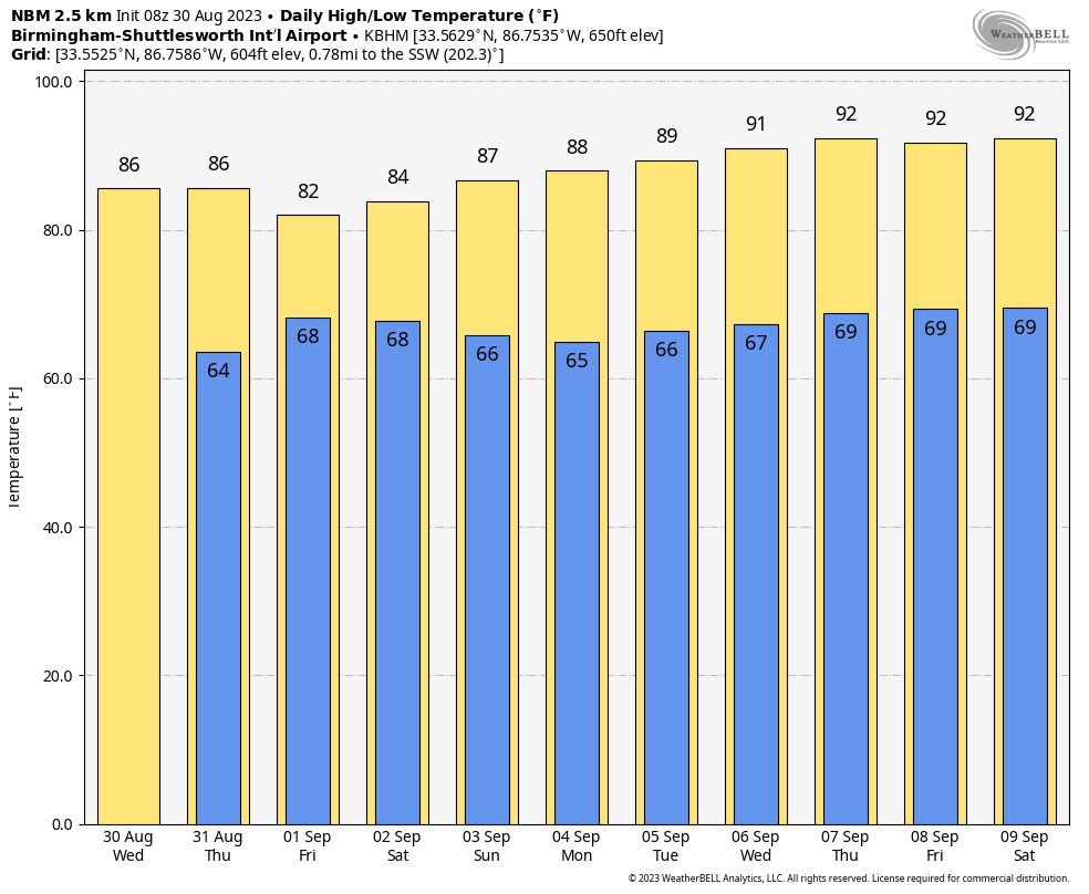
Tomorrow will be a sunny day with lower humidity values. Some of the cooler spots across North Alabama could reach the 50s early tomorrow morning… the high will be in the mid to upper 80s.
FRIDAY AND THE LABOR DAY WEEKEND: We are going to need to introduce the chance of scattered showers and thunderstorms Friday as an upper low moves into the region. The chance of any one spot seeing rain Friday is 30/40 percent, and highs will remain in the 80s with an occasionally cloudy sky.
The, for the Labor Day weekend, most of Alabama will be dry with mostly sunny days and fair nights. The exception is the southwest corner of the state, where a few scattered showers are possible Saturday and Sunday. Highs will be in the mid to upper 80s for the northern half of the state, with low 90s to the south.
NEXT WEEK: A fairly quiet pattern will continue next week with only isolated afternoon showers; highs will creep back into the low 90s for the latter half of the week. See the video briefing for maps, graphics, and more details.
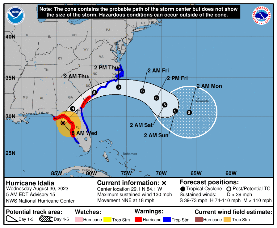
IDALIA NOTES: Idalia is a very dangerous category four hurricane with sustained winds of 130 mph early this morning. The center is 60 miles west of Cedar Key, or 90 miles south of Tallahassee. The eye wall will come onshore southeast of Tallahassee over Taylor and Dixie Counties by 7a CT… an extreme wind warning is in effect there.
Key messages…
*Catastrophic impacts from storm surge inundation of 12 to 16 feet above ground level and destructive waves are expected somewhere between the Wakulla/Jefferson County line and Yankeetown, Florida. Life-threatening storm surge inundation is likely elsewhere along portions of the Florida Gulf Coast where a Storm Surge Warning is in effect. Residents in these areas should follow any advice given by local officials.
*Destructive life-threatening winds will occur where the core of Idalia moves onshore in the Big Bend region of Florida, with hurricane conditions expected elsewhere in portions of the Hurricane Warning area along the Florida Gulf Coast. Strong winds will also spread inland across portions of northern Florida and southern Georgia near the track of the center of Idalia where Hurricane Warnings are in effect. Residents in these areas should be prepared for long-duration power outages. Damaging hurricane-force winds are likely in portions of eastern Georgia and southeastern South Carolina where Hurricane Warnings are now in effect.
OTHER TROPICAL ISSUES: Hurricane Franklin, with winds of winds of 110 mph, will pass north of Bermuda today… it will become post-tropical this weekend over the North Atlantic. Tropical Depression Eleven is a junk system far from land in the middle of the Atlantic and will dissipate within the next 24 hours. Other than Idalia, no tropical systems are expected near the U.S. for at least the next seven days.
ON THIS DATE IN 1838: A major tornado, possibly the worst in Rhode Island history, passed south of Providence. It uprooted and stripped trees of their branches, unroofed or destroyed many houses, and sucked water out of ponds. The tornado barely missed a local railroad depot, where many people were waiting for a train.
Loo for the next video briefing here by 3:00 this afternoon… enjoy the day!
Category: Alabama's Weather, ALL POSTS, Weather Xtreme Videos
About the Author (Author Profile)
James Spann is one of the most recognized and trusted television meteorologists in the industry. He holds the AMS CCM designation and television seals from the AMS and NWA. He is a past winner of the Broadcast Meteorologist of the Year from both professional organizations.Subscribe
If you enjoyed this article, subscribe to receive more just like it.


