Cold Front Arrives Tonight With Scattered Showers/Storms
RADAR CHECK: Scattered showers and thunderstorms continue to increase across Alabama this afternoon ahead of a cold front near the Shoals. We note SPC has introduced a “marginal risk” (level 1/5) of severe thunderstorms for the northeast corner of the state tonight… heavier storms there could produce strong winds this evening.
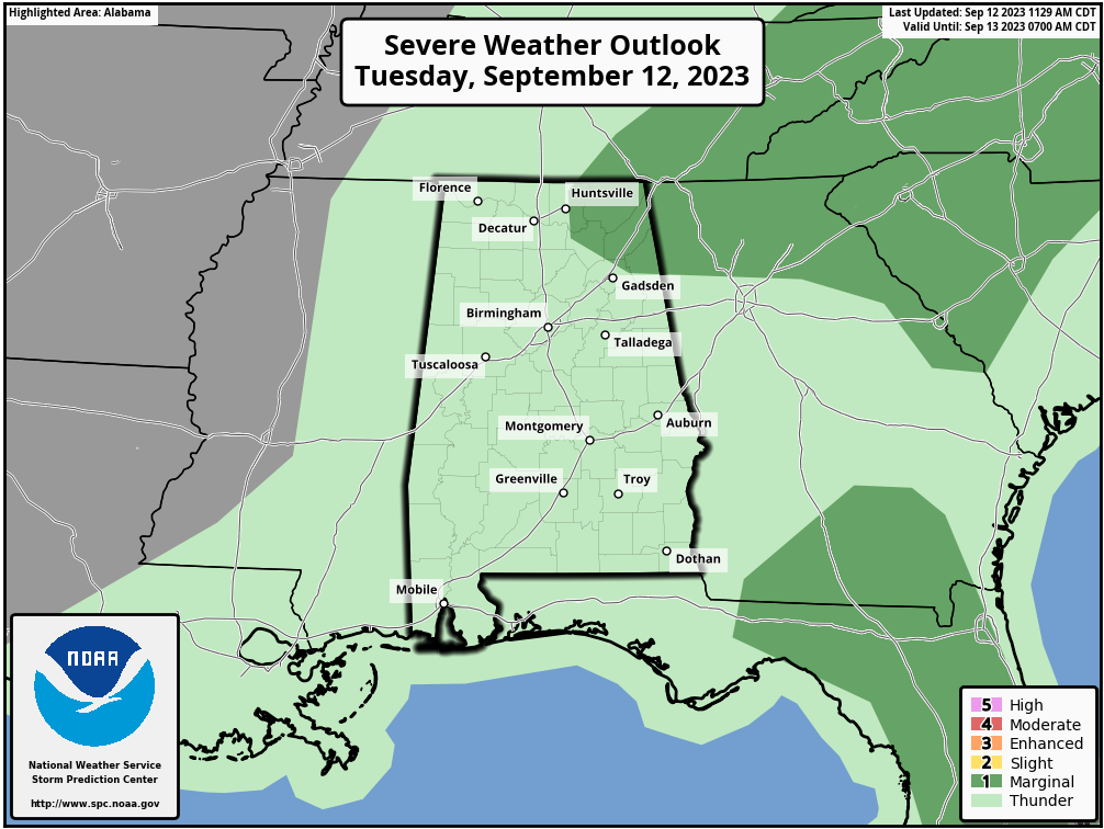
Scattered showers and storms remain possible through the night as the cold front drifts southward.
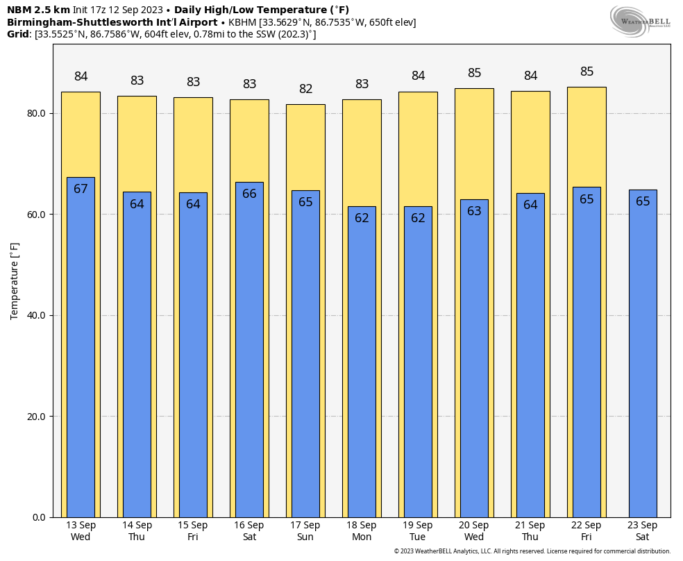
REST OF THE WEEK: A drier airmass will settle into the northern 2/3 of Alabama tomorrow and Thursday; the sky will be partly sunny both days with highs in the low to mid 80s. Showers will be confined to the southern counties, and even there many places will be dry. Then, on Friday, the chance of showers will increase statewide as a surface trough develops over the region. It won’t rain all day, but a few showers and possibly a thunderstorm are a good bet through Friday night.
THE ALABAMA WEEKEND: Occasional showers are likely Saturday as the weekend begins. Not a “wash-out”, but plan on some rain at times through Saturday night along with some risk of thunder. The sky will be mostly cloudy and the high will be in the low 80s for most places. Then, the trough pushes to the east, and drier air arrives Sunday as the sky becomes partly to mostly sunny by afternoon. The high Sunday will be in the 81-85 degree range.
NEXT WEEK: Global models are now advertising a very dry airmass for the Deep South, and most of the week looks rain-free with highs in the 80s and lows in the 60s, right at seasonal averages. See the video briefing for maps, graphics, and more details.
FOOTBALL WEATHER: For the high school games Friday night, a few periods of rain are possible with a mostly cloudy sky… some thunder can’t be ruled out. Temperatures will fall through the 70s.
Saturday, Alabama travels to Tampa to take on South Florida (2:30p CT kickoff)… the day will be hot and humid with a kickoff temperature around 90 degrees. A passing shower or thunderstorm is possible during the game.
Auburn hosts Samford Saturday evening at Jordan-Hare Stadium (6:00p CT kickoff)… the sky will be mostly cloudy with some rain possible at times. Temperatures will be in the mid to upper 70s.
And, UAB will host Louisiana Saturday evening in downtown Birmingham at Protective Stadium (6:00p CT kickoff)… much like Auburn, a few periods of rain are possible during the game. Mostly cloudy conditions with temperatures falling from near 80 at kickoff, to mid 70s by the fourth quarter.
TROPICS: Hurricane Lee this morning is about 540 miles south of Bermuda with winds of 115 mph. No significant change in strength is expected in the near-term with Lee due to its current structure and large wind field. Going forward, the large hurricane appears likely to begin upwelling cooler waters along its path, and in a few days it will encounter the cool wake left behind by recent western Atlantic hurricanes. Thus, gradual weakening is forecast through midweek. Later, a trough is expected to produce stronger deep-layer shear over Lee, and the hurricane is forecast to move over significantly cooler waters as it passes north of the Gulf Stream. As a result, more significant weakening is shown at days 4-5, along with completion of its extratropical transition. Despite the forecast weakening, it is important to note that the expanding wind field of Lee will produce impacts well away from the storm center.
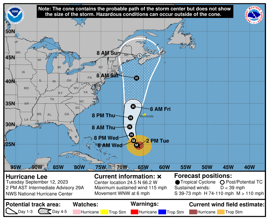
Lee will likely move into Nova Scotia this weekend, but some wind and rain will impact Cape Cod and the coast of Maine, much like a nor’easter.
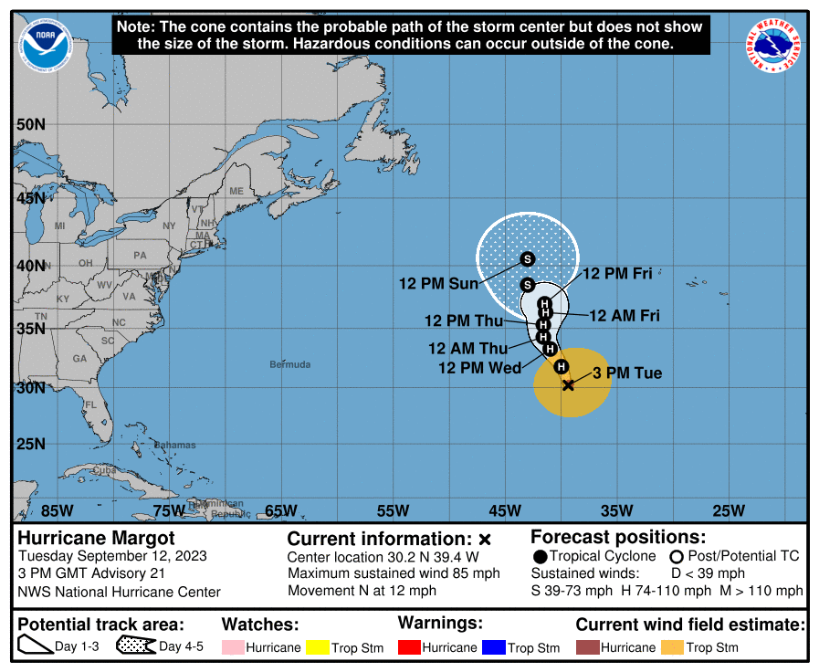
Hurricane Margot, with winds of 85 mph, is moving northward in the middle of the Atlantic far from land. It will begin to weaken this weekend over cooler water, and is no threat to any land area.
And, Invest 97L in the eastern Atlantic is expected to become Tropical Storm Nigel over the next few days… too early to know the final destination, but the pattern suggests this won’t be an issue for the Southeast U.S.
No tropical systems are expected near the Gulf of Mexico for at least the next seven days.
ON THIS DATE IN 1979: Hurricane Frederic made landfall at about 10 p.m. CT, passing over Dauphin Island and crossed the coastline near the Alabama/Mississippi border. A wind gust of 145 miles per hour was measured on equipment atop the Dauphin Island Bridge. The bridge was destroyed. A wind gust of 139 mph was measured at the Dauphin Island Sea Lab before the equipment failed.
At landfall, Frederic was a Category 4 on the Saffir-Simpson Hurricane Intensity Scale, raking the Mobile Bay area with winds gusting from 100-145 mph for several hours on the evening of September 12 through the early morning of September 13. Hurricane wind gusts were experienced as far inland as Choctaw County during the early morning hours of September 13.
A storm surge of 12 feet was observed in Gulf Shores. Nearly all structures within 200 yards of the Alabama coast were destroyed. There were only two fatalities as a direct result of Frederic. Total damages were 2.3 billion dollars, making Frederic the most expensive hurricane ever to strike the United States up to that point.
Frederic was the first hurricane to directly strike Mobile since 1932.
Look for the next video briefing here by 6:00 a.m. tomorrow…
Category: Alabama's Weather, ALL POSTS, Weather Xtreme Videos
About the Author (Author Profile)
James Spann is one of the most recognized and trusted television meteorologists in the industry. He holds the AMS CCM designation and television seals from the AMS and NWA. He is a past winner of the Broadcast Meteorologist of the Year from both professional organizations.Subscribe
If you enjoyed this article, subscribe to receive more just like it.


