Showers Possible Today/Tomorrow; Dry Next Week
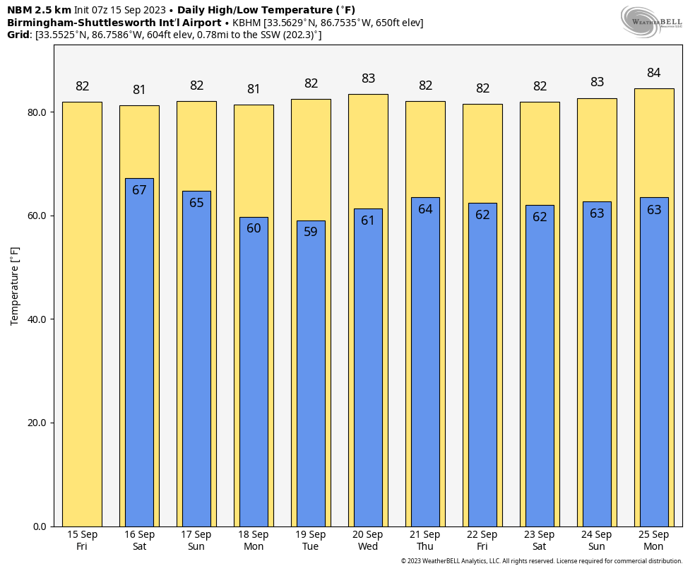
OCCASIONAL SHOWERS: The sky will be mostly cloudy across Alabama through tomorrow with occasional showers thanks to a surface trough nearby. The higher coverage of rain will be over the eastern half of the state, and there could be a rumble of thunder in spots. The rain won’t be continuous, and it won’t rain everywhere, but if you have something planned outdoors just be ready for a shower at any time. The chance of any one spot seeing rain today and tomorrow is 55/65 percent, and highs will be in the low to mid 80s.
The weather will trend drier on Sunday, but showers will remain possible over East and South Alabama ahead of a surface front passing through the state. Expect a mix of sun and clouds with a high in the 81-85 degree range.
NEXT WEEK: For now most of the week is looking dry with mostly sunny days and fair pleasant nights. Highs in the 80s, lows in the 60s… but many North Alabama communities will likely reach the 50s early Monday and Tuesday morning. See the video briefing for maps, graphics, and more details.
FOOTBALL WEATHER: For the high school games tonight, we have a risk of showers with temperatures falling through the 70s.
Tomorrow, Alabama travels to Tampa to take on South Florida (2:30p CT kickoff)… the day will be hot and humid with a kickoff temperature around 90 degrees. A passing shower or thunderstorm is likely during the game. Which, of course, means potential for a lightning delay.
Auburn hosts Samford tomorrow evening at Jordan-Hare Stadium (6:00p CT kickoff)… the sky will be mostly cloudy with showers possible. Temperatures will be in the mid to upper 70s.
And, UAB will host Louisiana tomorrow evening in downtown Birmingham at Protective Stadium (6:00p CT kickoff)… much like Auburn, a shower can’t be ruled out during the game. Mostly cloudy conditions with temperatures falling from near 80 at kickoff, to mid 70s by the fourth quarter.
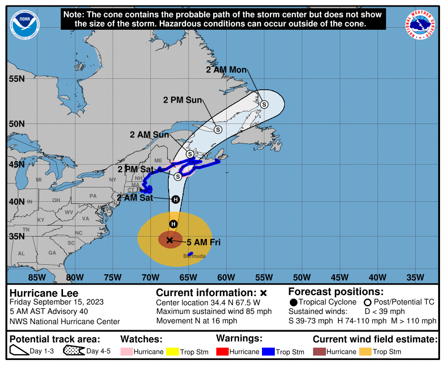
TROPICS: Hurricane Lee, with winds of 85 mph, is about 490 miles south/southeast of Nantucket, and is now moving north at 16 mph. There system becomes extratropical within the next 24 hours as it gains latitude, and it will move into western Nova Scotia tomorrow afternoon.
Tropical storm conditions and coastal flooding are expected to begin in southern New England this afternoon, and spread northward along the coast of New England and over portions of Atlantic Canada through tomorrow. These conditions are likely to lead to downed trees and potential power outages.
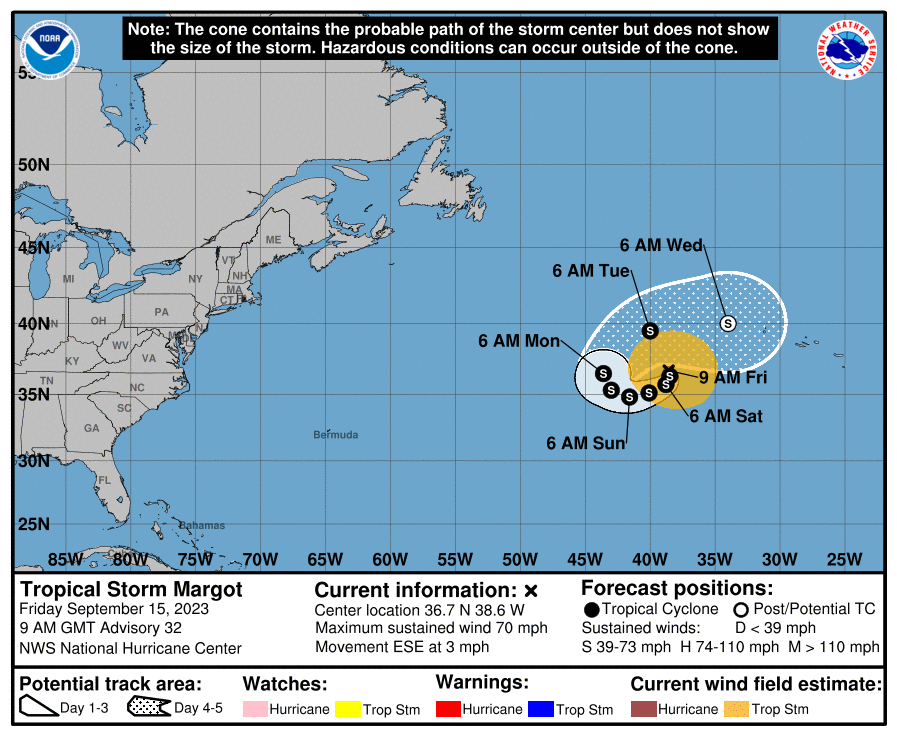
Tropical Storm Margot is in the Atlantic with winds of 70 mph; it will move little over the next five days and will stay far from land.
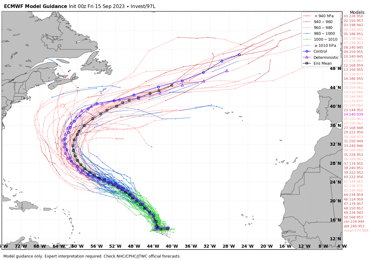
And, Invest 97L in the Central Atlantic is expected to become Tropical Storm Nigel over the next few days, but it will turn north and is no threat to land.
No tropical systems will threaten the Gulf of Mexico for at least the next 7-10 days.
ON THIS DATE IN 1945: A hurricane entered the south Florida coast at Homestead, curving northward right up through the center of Florida, remaining over land, and exited near Jacksonville Beach with winds gusting to 170 mph.
ON THIS DATE IN 2004: Hurricane Ivan was approaching the Alabama Gulf Coast; it would make landfall during the pre-dawn hours on September 16. Ivan was an upper end category three when it moved onto the coast with winds of 120 mph, and a storm surge of 10-15 feet. The storm was responsible for a total of 8 deaths in the western Florida Panhandle (7 in Escambia County and 1 in Santa Rosa County).
ON THIS DATE IN 2020: Slow moving Hurricane Sally, just south of the Alabama Gulf Coast, weakened due to an increase in wind shear and upwelling of colder waters before turning northeastward. Despite this increase in wind shear, it unexpectedly re-intensified, reaching Category 2 status early on September 16, before making landfall at peak intensity during the pre-dawn hours on September 16, near Gulf Shores, with maximum sustained winds of 110 mph.
Just one video briefing today, but I will post fresh forecast notes here this afternoon… enjoy the day!
Category: Alabama's Weather, ALL POSTS, Weather Xtreme Videos
About the Author (Author Profile)
James Spann is one of the most recognized and trusted television meteorologists in the industry. He holds the AMS CCM designation and television seals from the AMS and NWA. He is a past winner of the Broadcast Meteorologist of the Year from both professional organizations.Subscribe
If you enjoyed this article, subscribe to receive more just like it.


