Midday Nowcast: Mainly Cloudy with Showers at Times
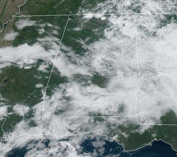
The next couple of days, scattered showers and storms are remain in the forecast due to surface trough in place across Alabama and Georgia. It won’t rain all day or every where, but the radar is going to be active with rain and storms at times the rest of today and tomorrow. Rain chances today and tomorrow are in the 50-60% range. We are also seeing more clouds than sun and that is keeping our highs in the upper 70s to mid 80s. Rain chances decrease Sunday as drier air moves into the state. Sunday look to be the best day of weather this weekend with more sunshine than clouds and highs in the low 80s.
FRIDAY NIGHT LIGHTS: For the high school games tonight, we have a risk of scattered showers, but nothing especially widespread or heavy. Temperatures will fall through the 70s.
FOOTBALL FORECAST: Tomorrow, Alabama travels to Tampa to take on South Florida (2:30p CT kickoff)… the day will be hot and humid with a kickoff temperature around 90 degrees. A passing shower or thunderstorm is likely during the game. Which, of course, means potential for a lightning delay.
Auburn hosts Samford tomorrow evening at Jordan-Hare Stadium (6:00p CT kickoff)… the sky will be mostly cloudy with a passing shower possible. Temperatures will be in the mid to upper 70s.
And, UAB will host Louisiana tomorrow evening in downtown Birmingham at Protective Stadium (6:00p CT kickoff)… much like Auburn, a shower can’t be ruled out during the game. Mostly cloudy conditions with temperatures falling from near 80 at kickoff, to mid 70s by the fourth quarter.
NEXT WEEK: As high pressure settles in over the Deep South, it will bring drier air, meaning less humidity, making it comfortable and beautiful next week. Most of the week looks rain-free with highs in the 80s and lows in the 60s and 50s, right at seasonal averages. Overall a splendid final official week of summer.
IN THE TROPICS: Soon to be Nigel…Invest 97L is now Tropical Depression 15…The depression is moving toward the northwest near 12 mph, and this general motion is expected to continue for the next few days. Maximum sustained winds are near 35 mph with higher gusts. Gradual strengthening is forecast, and the depression is expected to become a tropical storm late today and could become a hurricane late this weekend. The estimated minimum central pressure is 1007 mb (29.74 inches).
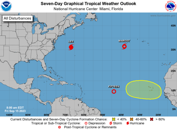
HURRICANE LEE: Lee is moving toward the north-northeast near 18 mph and a northward motion at a faster forward speed is expected through Saturday. On the forecast track, the center of Lee will continue to move farther away from Bermuda and approach the coast of New England and Atlantic Canada through Saturday. Lee is then expected to turn toward the north-northeast and northeast and move across Atlantic Canada Saturday night and Sunday.
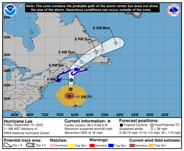
Maximum sustained winds are near 80 mph with higher gusts. Lee is expected to be a large and dangerous storm when it reaches eastern New England and Atlantic Canada. Hurricane-force winds extend outward up to 105 miles from the center and tropical-storm-force winds extend outward up to 320 miles. The minimum central pressure is 962 mb (28.41 inches) based on data from the NOAA and Air Force Hurricane Hunter aircrafts.
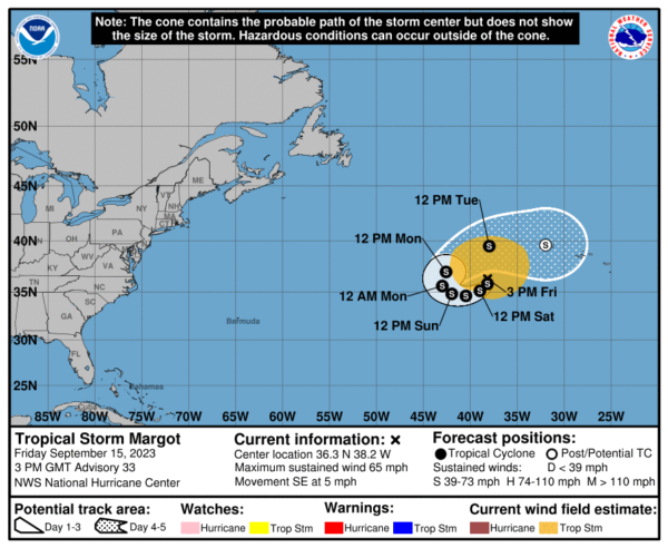
TROPICAL STORM MARGOT: Margot is moving toward the southeast near 5 mph, and is expected to make a slow clockwise loop during the next day or two. A faster northeastward motion is forecast by Monday. Maximum sustained winds have decreased to near 65 mph with higher gusts. Some additional weakening is forecast during the next couple of days. Tropical-storm-force winds extend outward up to 300 miles from the center. The estimated minimum central pressure is 990 mb (29.24 inches).
BEACH FORECAST CENTER: Get the latest weather and rip current forecasts for the beaches from Fort Morgan to Panama City on our Beach Forecast Center page. There, you can select the forecast of the region that you are interested in visiting.
WORLD TEMPERATURE EXTREMES: Over the last 24 hours, the highest observation outside the U.S. was 117.1F at King Fahad International Airport, Saudi Arabia. The lowest observation was -84.8F Dome A, Antarctica.
CONTIGUOUS TEMPERATURE EXTREMES: Over the last 24 hours, the highest observation was 108F at Death Valley, CA and Falcon Lake, TX. The lowest observation was 23F at Davis, WV.
Category: Alabama's Weather, ALL POSTS
About the Author (Author Profile)
Macon, Georgia Television Chief Meteorologist, Birmingham native, and long time Contributor on AlabamaWX. Stormchaser. I did not choose Weather, it chose Me. College Football Fanatic. @Ryan_StinnetSubscribe
If you enjoyed this article, subscribe to receive more just like it.


