Midday Nowcast: Sunshine from the Top of the State to the Bottom
Greetings from the beautiful, sun kissed, white sand beaches of the immaculate Alabama Gulf Coast…Don’t tell anyone this, but I learned years ago, the best time to take a trip to the Northern Gulf Coast is mid-September through October…The crowds are gone, the prices have dropped, the water is still in the mid-80s, and the weather is amazing…most of the time. Sure you have to take your chances and may have to dodge a hurricane every several years, but the odds of that are still statistically low. Plus you can always buy travel insurance.
THE FINAL WEEK OF SUMMER: Well officially anyways, as the autumnal equinox occurs on Saturday, but until then, expect splendid, early, fall-like weather all week. Sunny days, refreshing nights, low humidity, and very tolerable afternoon highs. Highs most of this week, will range from the low to upper 80s. Lows will be in the 50s the next several nights before inching back up in those 60s.
HELLO FALL: With falls official arrival Saturday at 1:49 AM CDT, the pattern doesn’t change much and the weather looks dry with highs holding in the 80s, and lows in the 60s. Lots of sunshine both Saturday and Sunday. Next week starts off the same way, but by midweek, we could have to increase those rain chances as moisture levels begin to rise.
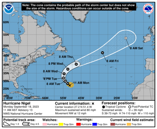
IN THE TROPICS: We only have one active storm at this time in the Atlantic, and that is Hurricane Nigel…Nigel is moving toward the northwest near 12 mph, and this general motion is expected to continue for the next couple of days. Nigel is then forecast to turn northward late Tuesday, and then accelerate northeastward through the rest of the week. Maximum sustained winds are near 80 mph with higher gusts. Nigel is forecast to rapidly strengthen into a major hurricane on Tuesday. A gradual weakening trend could start on Wednesday. Hurricane-force winds extend outward up to 25 miles from the center and tropical-storm-force winds extend outward up to 160 miles. The estimated minimum central pressure is 984 mb (29.06 inches).
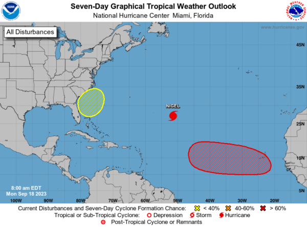
Elsewhere in the basin, there are two other areas of interest, which of course we will keep our eyes on this week. A tropical wave is expected to move off the west coast of Africa by Wednesday. Environmental conditions are forecast to be conducive for gradual development of the wave thereafter, and a tropical depression is likely to form late this week or this weekend while the system moves westward across the eastern and central tropical Atlantic. Formation chance through 7 days…high…70 percent.
Also, a non-tropical area of low pressure is forecast to form near the southeastern coast of the United States late this week. This system could acquire some subtropical characteristics this weekend if it remains offshore while it moves slowly northward or northwestward. Formation chance through 7 days…low…30 percent.
BEACH FORECAST CENTER: Get the latest weather and rip current forecasts for the beaches from Fort Morgan to Panama City on our Beach Forecast Center page. There, you can select the forecast of the region that you are interested in visiting.
WORLD TEMPERATURE EXTREMES: Over the last 24 hours, the highest observation outside the U.S. was 117.1F at Ouallene, Algeria. The lowest observation was -87.7F Amundsen-Scott South Pole Station, Antarctica.
CONTIGUOUS TEMPERATURE EXTREMES: Over the last 24 hours, the highest observation was 108F at Death Valley, CA. The lowest observation was 22F at Peter Sinks, UT.
Category: Alabama's Weather, ALL POSTS
About the Author (Author Profile)
Macon, Georgia Television Chief Meteorologist, Birmingham native, and long time Contributor on AlabamaWX. Stormchaser. I did not choose Weather, it chose Me. College Football Fanatic. @Ryan_StinnetSubscribe
If you enjoyed this article, subscribe to receive more just like it.


