Dry Pattern To Continue Across Alabama
ANOTHER COOL MORNING: These are temperatures across Alabama must before sunrise…
Tuckers Chapel (Cherokee County) 50
Gadsden 51
Fort Payne 51
Jasper 52
Cottondale 52
Haleyville 53
Trussville 53
Pell City 53
Muscle Shoals 53
Decatur 54
Chelsea 54
Hueytown 54
Huntsville 55
Anniston 56
Tuscaloosa 57
Evergreen 57
Jemison 59
Birmingham 60
Dothan 61
Mobile 65
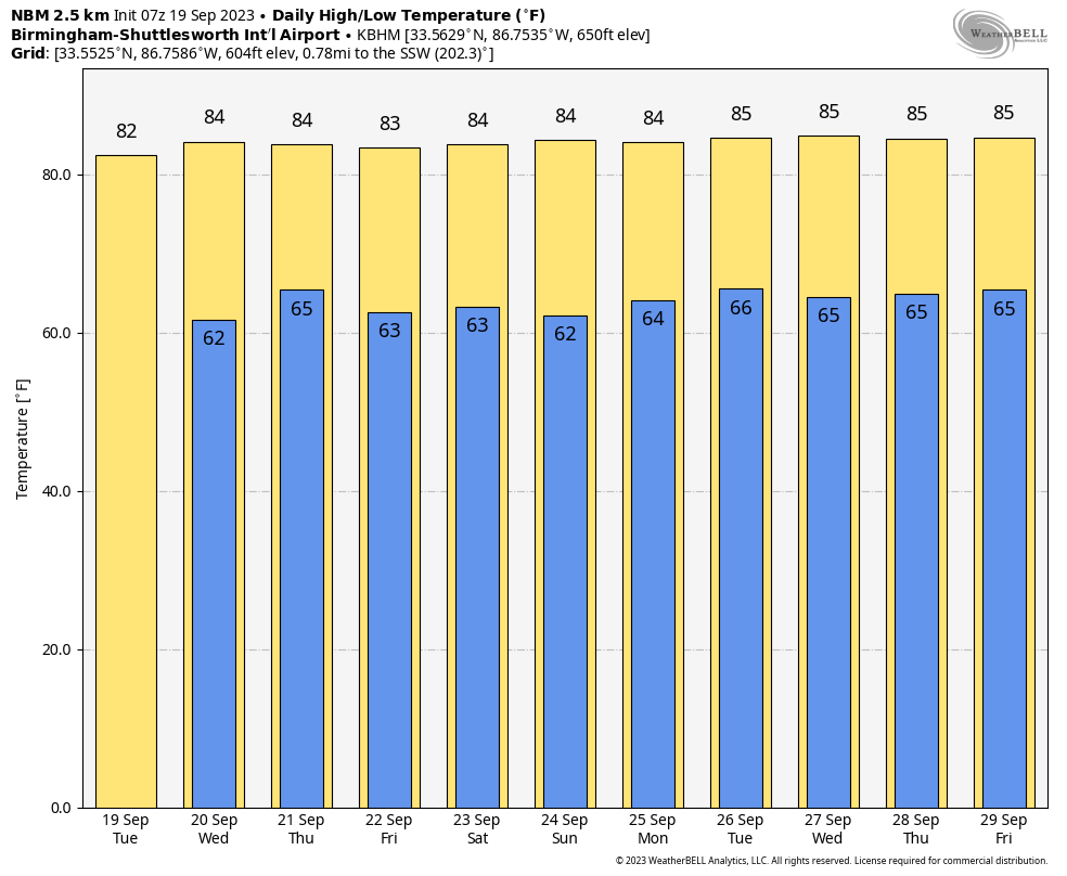
Today will be another sunny day with low humidity along with a high in the 80s.
REST OF THE WEEK AND THE WEEKEND: A dry airmass will stay in place, and most places will stay dry through the weekend with highs mostly in the 80s and lows mostly in the 60s. Cooler spots will be in the 50s.
We might consider mentioning a slight risk of a shower Thursday due to an upper air trough passing through, and on Sunday with a surface front approaching, but for now the risk of any one spot getting wet on those days is only 10 percent, and not really worth mentioning in the forecast.
NEXT WEEK: The dry pattern continues; we see no major rain events through the week as an upper ridge builds across the Deep South. Highs hold in the 80s… See the video briefing for maps, graphics, and more details.
FOOTBALL WEATHER: The sky will be clear for the high school games across Alabama Friday night, with temperatures falling through the 70s, possibly reaching the 60s by the fourth quarter.
Saturday Auburn will travel to College Station to take on Texas A&M (11a CT kickoff)… the sky will be mostly sunny with temperatures rising from near 88 at kickoff to near 93 by the final whistle.
Alabama will host Ole Miss at Bryant-Denny Stadium Saturday (2:30p CT kickoff)… the sky will be mostly sunny with temperatures in the mid 80s.
And, UAB will be in Athens to take on Georgia Saturday evening (6:30p CT kickoff). The weather looks dry with a mostly clear sky… temperatures will fall from near 77 at kickoff, into the 60s by the fourth quarter.
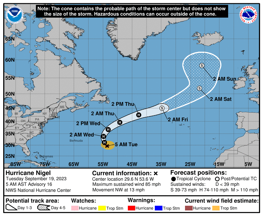
TROPICS: Hurricane Nigel, in the middle of the Atlantic far from land, is packing sustained winds of 85 mph. It will move northeast with no impact to any landmass before becoming post-tropical this weekend.
A surface is low is expected to form off the South Atlantic coast of the U.S. by Friday and Saturday; it could acquire some tropical characteristics before moving into eastern North Carolina. NHC gives it a 30 percent of development.
And, new wave will move off the African continent tomorrow; NHC gives this one a 70 percent chance of becoming a tropical depression or storm on the journey across the Atlantic… too early to know if this will impact any land mass.
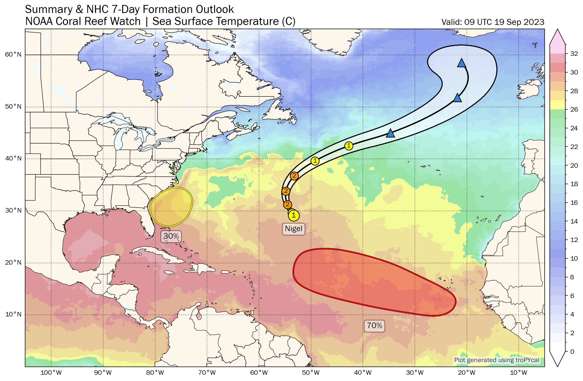
No tropical systems will impact the Gulf of Mexico for at least the next 7-10 days.
ON THIS DATE IN 1947: A hurricane made landfall near the Chandeleur Islands, LA. Wind gusts of 112 mph and a central pressure of 967 mb were measured at Moisant International Airport. A storm surge of 9.8 feet reached Shell Beach, Lake Borgne. Moisant Airport field was flooded by two ft. of water while Jefferson Parish was flooded to depths of 3.28 ft. New Orleans suffered $100 million in damages. Total loss of life was 51 people. As a result of this storm, hurricane protection levees were built along the south shore of Lake Pontchartrain to protect Orleans and Jefferson Parishes from future storm surges.
ON THIS DATE IN 2022: The eye of Hurricane Fiona made landfall along the coast of the Dominican Republic near Boca de Yuma at 07:30 UTC on September 19. It was the first hurricane to make landfall in the country in 18 years.
Look for the next video briefing here by 3:00 this afternoon… enjoy the day!
Category: Alabama's Weather, ALL POSTS, Weather Xtreme Videos
About the Author (Author Profile)
James Spann is one of the most recognized and trusted television meteorologists in the industry. He holds the AMS CCM designation and television seals from the AMS and NWA. He is a past winner of the Broadcast Meteorologist of the Year from both professional organizations.Subscribe
If you enjoyed this article, subscribe to receive more just like it.


