Dry Pattern Continues; Warm Days, Pleasant Nights
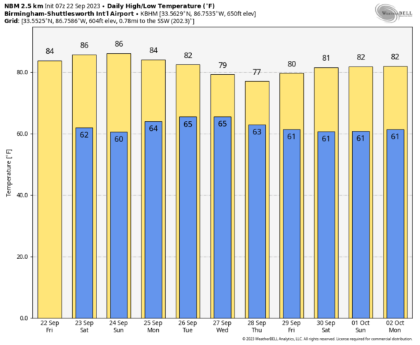
CALM PATTERN CONTINUES: Most of Alabama will stay dry through Sunday with mostly sunny days and fair nights. Highs in the 80s, lows mostly in the 60s. We will mention a small risk of a shower Sunday afternoon over the western half of the state, but the chance of any one spot seeing rain is 10-20 percent.
NEXT WEEK: We will bring a chance of showers statewide Monday through Thursday. Nothing too heavy, and nothing really widespread. But some rain is possible at times as moisture levels rise across the Deep South. Drier air returns by Friday… highs hold mostly in the 80s, but North Alabama communities could see highs in the mid to upper 70s over the latter half of the week. See the video briefing for maps, graphics, and more details.
FOOTBALL WEATHER: The sky will be clear for the high school games across Alabama tonight, with temperatures falling through the 70s, possibly reaching the 60s by the fourth quarter.
Tomorrow Auburn will travel to College Station to take on Texas A&M (11a CT kickoff)… the sky will be mostly sunny with temperatures rising from near 88 at kickoff to near 94 by the final whistle.
Alabama will host Ole Miss at Bryant-Denny Stadium tomorrow (2:30p CT kickoff)… the sky will be mostly sunny with temperatures in the mid 80s.
And, UAB will be in Athens to take on Georgia tomorrow evening (6:30p CT kickoff). The weather looks dry with a mostly clear sky… temperatures will fall from near 77 at kickoff, into the 60s by the fourth quarter.
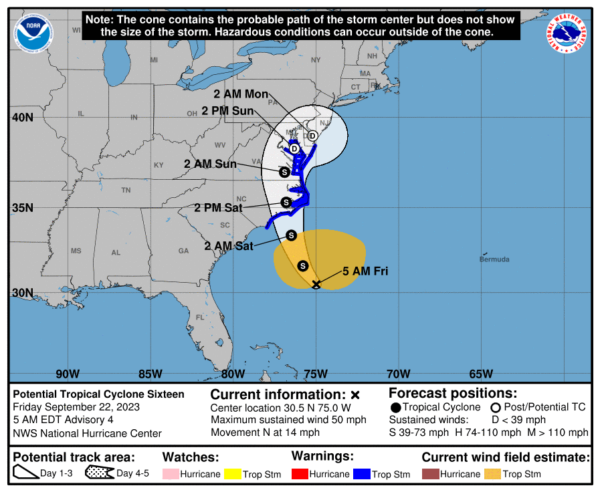
TROPICS: Potential Tropical Cyclone 16 is expected to become a subtropical or tropical storm later today (the name will be Ophelia). It moves into the North Carolina coast/Outer Banks tomorrow morning.
A Tropical Storm Warning is in effect for from Cape Fear North Carolina to Fenwick Island Delaware, including Albemarle and Pamlico Sounds, Tidal Potomac south of Cobb Island, and Chesapeake Bay south of North Beach. There is a danger of life-threatening storm surge inundation over portions of eastern North Carolina and southeastern Virginia, including Pamlico and Albemarle Sounds, and the lower Chesapeake Bay, where Storm Surge Warnings are in place. Residents in these areas should follow advice given by local officials. Heavy rainfall from this system could produce localized urban and small stream flooding impacts across the eastern mid-Atlantic states from North Carolina to New Jersey through Sunday.
Elsewhere, Nigel has become post-tropical in the North Atlantic and the last advisory has been issued.
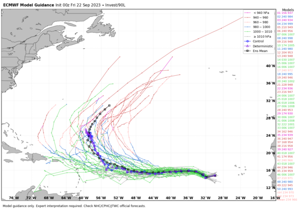
In the eastern Atlantic, showers and thunderstorms continue to show signs of organization in association with a broad area of low pressure (Invest 90L) located about 500 miles west-southwest of the Cabo Verde Islands. Environmental conditions are forecast to be conducive for gradual development of this system, and a tropical depression is likely to form this weekend or early next week while the system moves generally westward at 10 to 15 mph across the eastern and central tropical Atlantic.
Global models suggest 90L will turn north before reaching the Lesser Antilles, and well before reaching the U.S.
No tropical systems will threaten the Gulf of Mexico for at least the next 7 days.
ON THIS DATE IN 2006: The tristate area of Missouri, Illinois, and Kentucky was struck by the worst tornado outbreak in the recorded history during the month of September. One supercell produced a long-track F4 tornado across southeastern Missouri into southwestern Illinois. This tornado traveled 27.5 miles.
Just one video briefing today; I will be live at Pelham High School on ABC 33/40 this evening before the Friday Night Rivals game (Helena at Pelham)… but I will post fresh notes here this afternoon. Enjoy the day!
Category: Alabama's Weather, ALL POSTS, Weather Xtreme Videos


