Midday Nowcast: Sun, Clouds, and Some Showers
REST OF OUR MONDAY: We are seeing a mix of sun and clouds today with some isolated showers expected on the radar this afternoon, evening, and overnight. High are in the 80s, while lows tonight will slip into the upper 60s for most locations.
REST OF THE WEEK: Scattered showers will remain possible statewide tomorrow through Thursday. Again, nothing too heavy or widespread, and most locations will remain dry. Rain chances all three days are in the 30-40% range. Drier air begins to slip into the state late Thursday. Highs will be in the low to upper 80s depending on the amount of sunshine your location see. Friday looks rain-free with a good supply of sunshine. Highs Friday should be in the low 80s, and with lower humidity, it’ll be very nice and comfortable.
WEEKEND AND BEYOND: For now the weather looks dry over the weekend, and through much of next week with mostly sunny warm days and fair pleasant nights. Highs in the 80s, lows in the 60s with cooler spots seeing upper 50s.
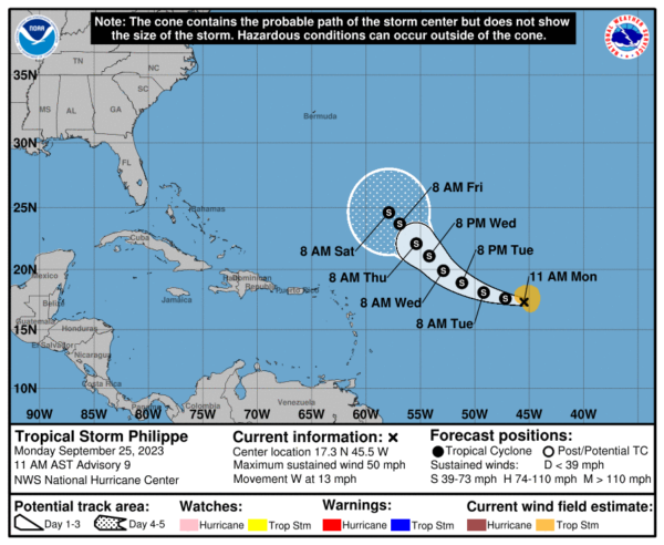
TROPICAL STORM PHILIPPE: Philippe is moving toward the west near 13 mph. A turn to the west-northwest is expected by tonight, and a northwestward motion is forecast to occur in a couple of days. Maximum sustained winds remain near 50 mph with higher gusts. Little change in strength is forecast during the next few days. Tropical-storm-force winds extend outward up to 115 miles from the center. The estimated minimum central pressure is 1000 mb (29.53 inches).
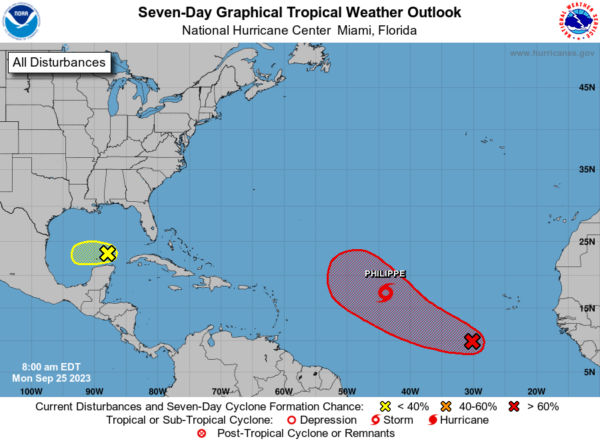
ELSEWHERE IN THE TROPICS: A trough of low pressure is producing disorganized shower activity over portions of the southeastern Gulf of Mexico. Development, if any, of this system is expected to be slow to occur over the next day or two while it moves slowly westward. The disturbance is expected to move into unfavorable environmental conditions by the middle of the week, ending its chances for development. Formation chance through 7 days…low…10 percent.
In the Eastern Tropical Atlantic, Invest 91L is an area of low pressure located several hundred miles southwest of the Cabo Verde Islands continues to produce disorganized showers and thunderstorms. Environmental conditions are forecast to be conducive for additional development, and a tropical depression is likely to form within the next few days as the system moves west-northwestward across the central tropical Atlantic. Formation chance through 7 days…high…80 percent.
Remaining names on list this year are Rina, Sean, Tammy, Vince, and Whitney.
BEACH FORECAST CENTER: Get the latest weather and rip current forecasts for the beaches from Fort Morgan to Panama City on our Beach Forecast Center page. There, you can select the forecast of the region that you are interested in visiting.
WORLD TEMPERATURE EXTREMES: Over the last 24 hours, the highest observation outside the U.S. was 115.5F at Nasiriya, Iraq. The lowest observation was -84.5F Concordia, Antarctica.
CONTIGUOUS TEMPERATURE EXTREMES: Over the last 24 hours, the highest observation was 110F at Rio Grande Village, TX. The lowest observation was 20F at Foxpark, WY.
Category: Alabama's Weather, ALL POSTS
About the Author (Author Profile)
Macon, Georgia Television Chief Meteorologist, Birmingham native, and long time Contributor on AlabamaWX. Stormchaser. I did not choose Weather, it chose Me. College Football Fanatic. @Ryan_StinnetSubscribe
If you enjoyed this article, subscribe to receive more just like it.


