Midday Nowcast: Dry Tuesday, Rain Returns Tomorrow
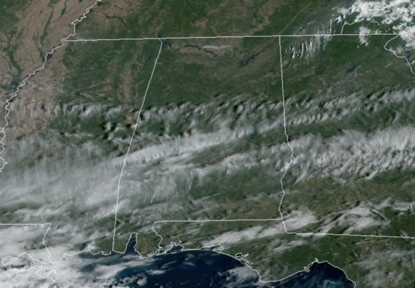
We remain dry today, but we are starting to see more clouds stream in from the southwest ahead of our next weathermaker due in here tomorrow. Most locations are seeing highs in the low 80s this afternoon. Tonight will not be as cool as lows only fall into the upper 50s and lower 60s.
FOOTBALL WEATHER: Jacksonville State will host Liberty tonight (6:30p CT kickoff)… the sky will be mostly fair with temperatures falling from near 75 at kickoff, into the 60s by the second half. No risk of rain.
RAIN RETURNS TOMORROW: An are of low pressure loaded with tropical moisture will bring beneficial rain to Alabama tomorrow, but South Alabama will be the big winner when it comes to rainfall totals from this event. The most widespread and heaviest rain will be south of U.S. 80 (Demopolis to Montgomery to Opelika), where 1-3 inches are likely.
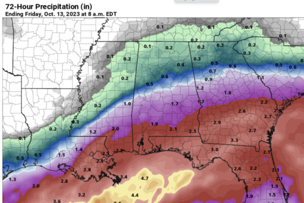
For now it looks like places like Birmingham, Tuscaloosa, and Anniston could see up to 1/2 inch, with only 1/4 inch for the Tennessee Valley. This could change, it all depends on the northward extent of the rain. The rain will move out of the state late tomorrow night, and for now Thursday looks like a dry day; the sky becomes partly sunny. Highs will be in the 70s both tomorrow and Thursday.
FRIDAY AND THE WEEKEND: An approaching cold front will bring a chance of showers statewide Friday and Friday night. Unfortunately it looks like rain amounts will be rather light and spotty with limited moisture available. Then, the sky will clear Saturday, and Sunday will feature sunshine in fully supply. The high Saturday will be in the be in the low to mid 70s, then dropping into the 60s Sunday with a cool north breeze.
NEXT WEEK: For now most of the week looks dry with sunny pleasant days and clear cool nights; highs will be mostly in the 60s with lows in the 40s. With moderating temperatures into the 70s for the second half of the week. More fantastic fall weather for all of Alabama.
IN THE TROPICS: We have two features: In the far Eastern Tropical Atlantic, Invest 92L is a broad area of low pressure located several hundred miles southwest of the Cabo Verde Islands continues to produce a large area of showers and thunderstorms. Environmental conditions appear conducive for gradual development, and a tropical depression is likely to form during the next couple of days while the system moves west-northwestward or northwestward across the eastern tropical Atlantic. Formation chance through 48 hours…high…70 percent. Formation chance through 7 days…high…80 percent.
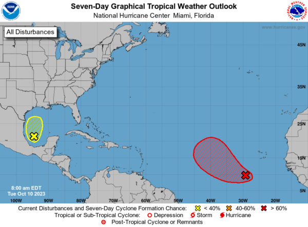
Closer to home in the Southwestern Gulf of Mexico, we now have Invest 93L. Showers and thunderstorms have increased some, but remain disorganized, in association with an area of low pressure over the southwestern Gulf of Mexico. While environmental conditions appear only marginally favorable, surface pressures have been falling near the system, and it has a short window to develop further over the next day or so. However, by Wednesday morning the system is forecast to merge with a developing frontal system over the western Gulf of Mexico. An Air Force Reserve Reconnaissance aircraft is scheduled to investigate the system later today, if necessary.
Regardless of tropical cyclone development, the system is forecast to produce gale-force winds over portions of the northern Gulf of Mexico by Wednesday, and potentially heavy rainfall along the Gulf Coast by the latter portion of this week. Formation chance through 7 days…low…30 percent.
The remaining names on list this year are Sean, Tammy, Vince, and Whitney.
BEACH FORECAST CENTER: Get the latest weather and rip current forecasts for the beaches from Fort Morgan to Panama City on our Beach Forecast Center page. There, you can select the forecast of the region that you are interested in visiting.
WORLD TEMPERATURE EXTREMES: Over the last 24 hours, the highest observation outside the U.S. was 118.9F at Sitka, Eswatini. The lowest observation was -85.5F Dome A, Antarctica.
CONTIGUOUS TEMPERATURE EXTREMES: Over the last 24 hours, the highest observation was 106F at Tecopa, CA. The lowest observation was 18F at Grand Lake, CO.
Category: Alabama's Weather, ALL POSTS
About the Author (Author Profile)
Macon, Georgia Television Chief Meteorologist, Birmingham native, and long time Contributor on AlabamaWX. Stormchaser. I did not choose Weather, it chose Me. College Football Fanatic. @Ryan_StinnetSubscribe
If you enjoyed this article, subscribe to receive more just like it.


