Midday Nowcast: Fantastic Fall Weather
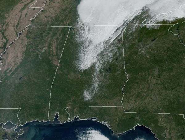
We are seeing some lingering clouds over North and Central Alabama today, but later this afternoon sunshine will be in full supply today across state, and tomorrow will be the same way. Expect a slow warming trend; highs are in the upper 60s today, but expect low to mid 70s statewide by tomorrow afternoon. Nights will remain chilly with widespread 40s.
LATE WEEK FRONT: Thursday will be dry, but clouds will be increasing, and we will bring in a chance of rain statewide Thursday night and Friday ahead of a surface cold front. Moisture will be limited, and rain amounts will be light; generally under a half an inch. The high Thursday will be in the low 70s. Highs fall back into the mid and upper 60s Friday under a mostly cloudy sky. Good news, the rain should be out of the state by the time those Friday night football games kick off.
FRIDAY NIGHT LIGHTS: We expect gradual clearing with temperatures falling from near 65° at kickoff, into the upper 50s by the final whistle.
ANOTHER FANTASTIC FALL WEEKEND: Another surge of dry air rolls into the state Friday night, and the weekend will feature sunny pleasant days and clear cool nights. Highs will range from the upper 60s to lower 70s; lows mostly in the 40s.
FOOTBALL WEATHER: Saturday, UAB will host Memphis at Protective Stadium in downtown Birmingham (11a CT kickoff)… the sky will be sunny with temperatures rising from near 68 at kickoff, to around 72 degrees by the fourth quarter.
Alabama hosts Tennessee at Bryant-Denny Stadium in Tuscaloosa (2:30p CT kickoff). It will be a fine fall afternoon with temperatures in the low to mid 70s.
And, Auburn will host Ole Miss Saturday evening (6:00p CT kickoff) at Jordan-Hare Stadium. Expect a clear sky with temperatures falling from near 70 at kickoff, into the low 60s by the final whistle.
NEXT WEEK: A ridge will build across the Deep South, meaning dry weather is likely through the week with highs mostly in the 70s, and lows in the 40s and 50s.
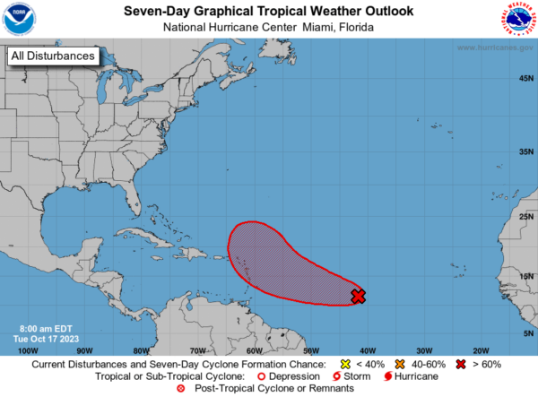
IN THE TROPICS: Still watching Invest 94L in the Central Tropical Atlantic, as it will likely become Tammy by the weekend. This broad area of low pressure located over the central tropical Atlantic about 1100 miles east of the Windward Islands continues to produce a large area of disorganized showers and thunderstorms. Environmental conditions are expected to remain conducive for gradual development, and a tropical depression will likely form during the next 2-3 days while the system moves westward to west-northwestward across the central and western tropical Atlantic. Interests in the Lesser Antilles should monitor the progress of this system. Formation chance through 48 hours…medium…60 percent. Formation chance through 7 days…high…80 percent.
The remaining names on list this year are Tammy, Vince, and Whitney.
BEACH FORECAST CENTER: Get the latest weather and rip current forecasts for the beaches from Fort Morgan to Panama City on our Beach Forecast Center page. There, you can select the forecast of the region that you are interested in visiting.
WORLD TEMPERATURE EXTREMES: Over the last 24 hours, the highest observation outside the U.S. was 128.8F at Siteki, Eswatini. The lowest observation was -83.0F Concordia, Antarctica.
CONTIGUOUS TEMPERATURE EXTREMES: Over the last 24 hours, the highest observation was 105F at Phoenix, AZ. The lowest observation was 16F at Angel Fire, NM.
Category: Alabama's Weather, ALL POSTS
About the Author (Author Profile)
Macon, Georgia Television Chief Meteorologist, Birmingham native, and long time Contributor on AlabamaWX. Stormchaser. I did not choose Weather, it chose Me. College Football Fanatic. @Ryan_StinnetSubscribe
If you enjoyed this article, subscribe to receive more just like it.


