Showers Late Thursday/Thursday Night; Ending Friday
BLUE SKY: Most of Alabama is enjoying sunshine in full supply this afternoon with temperatures mostly in the 60s. The exception is the far northern part of the state… stubborn clouds are hanging tough around Huntsville and Athens at mid-afternoon. Those clouds will dissipate this evening, and tonight will be clear and cool with lows mostly in the 40s.
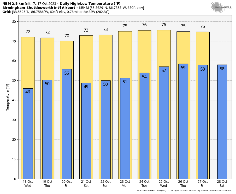
Tomorrow will be another sunny day with a high in the 70s.
THURSDAY/FRIDAY: Clouds will increase Thursday ahead of a cold front, and we will mention a chance of showers statewide Thursday afternoon and Thursday night. Moisture will be limited, and rain amounts will likely be under 1/2 inch. Showers will end Friday morning, and a new surge of dry air will roll into the state Friday night. The rain should be over by the time the high school football games begin Friday evening. Highs will be mostly in the 70-75 degree range both days.
THE ALABAMA WEEKEND: A dry airmass will cover Alabama and the Deep South over the weekend. We expect sunny mild afternoons and clear cool nights; highs will be in the 70s with lows in the 40s and 50s. Delightful fall weather.
NEXT WEEK: An upper ridge builds over the region, and for now the week looks dry with highs in the 70s, and lows mostly in the 50s. See the video briefing for maps, graphics, and more details.
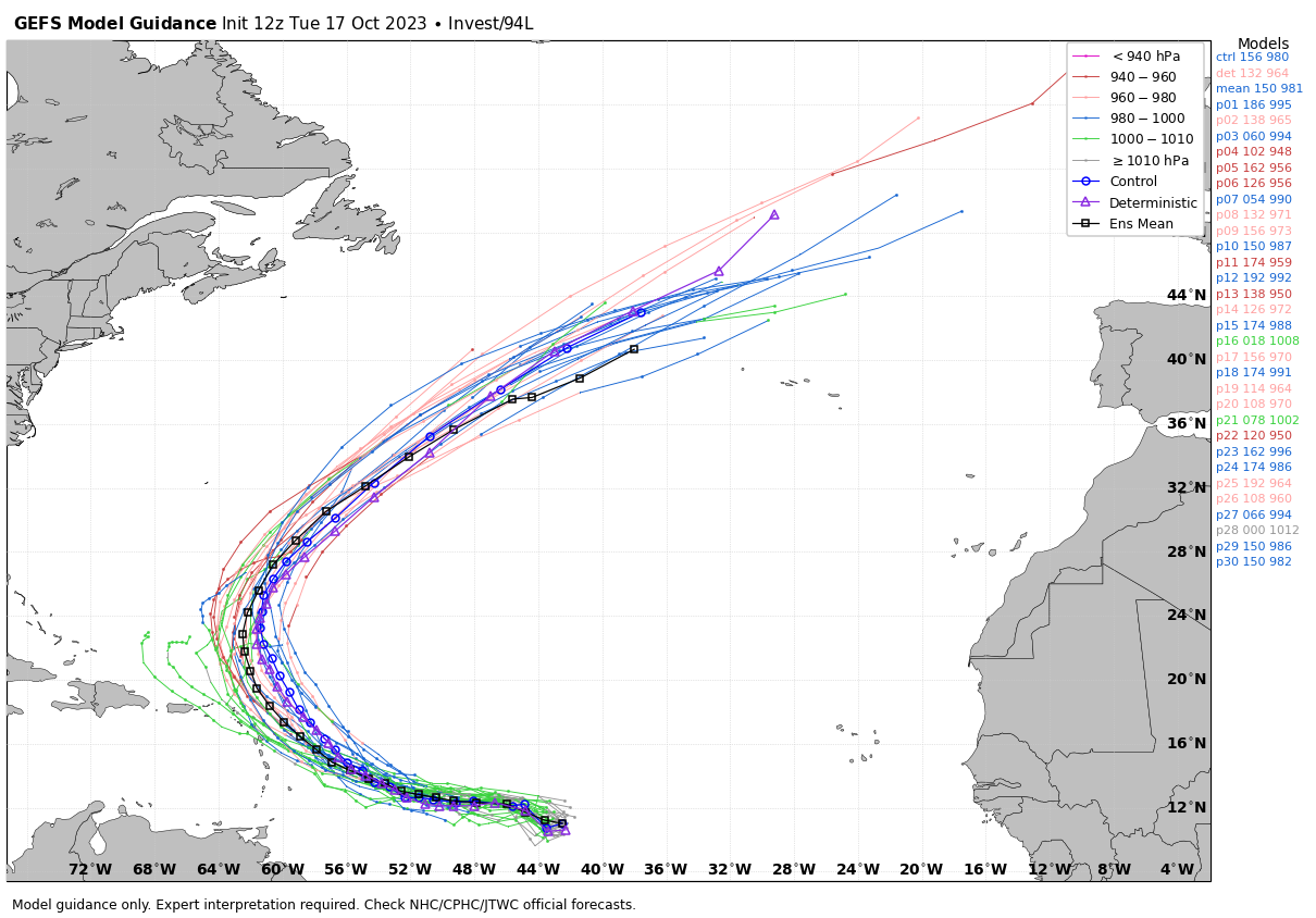
TROPICS: Satellite images indicate that a broad area of low pressure (Invest 94L) located about 1100 miles east of the Windward Islands has become better defined since this morning, and the associated showers and thunderstorms are also showing signs of organization. Environmental conditions are expected to remain conducive for gradual development, and a tropical depression will likely form during the next day or two while the system moves westward to west-northwestward across the central and western tropical Atlantic.
Interests in the Lesser Antilles should monitor the progress of this system. Additional information, including gale warnings, can be found in High Seas Forecasts issued by the National Weather Service. Regardless of development, this system has the potential to bring gusty winds, heavy rainfall and flooding to portions of the Lesser Antilles beginning Friday.
Global models show it turning northward, then out to sea well before getting close to the U.S. NHC gives it an 80 percent chance of development over the next seven days.
FOOTBALL WEATHER: For the high school games Friday night we expect a clearing sky with temperatures falling from near 65 at kickoff, into the upper 50s by the final whistle.
Saturday, UAB will host Memphis at Protective Stadium in downtown Birmingham (11a CT kickoff)… the sky will be sunny with temperatures rising from near 68 at kickoff, to around 72 degrees by the fourth quarter.
Alabama hosts Tennessee at Bryant-Denny Stadium in Tuscaloosa (2:30p CT kickoff). It will be a fine fall afternoon with temperatures in the low to mid 70s.
And, Auburn will host Ole Miss Saturday evening (6:00p CT kickoff) at Jordan-Hare Stadium. Expect a clear sky with temperatures falling from near 70 at kickoff, into the low 60s by the final whistle.
COMING SOON: Don’t forget Alabama’s tornado season begins in less than one month. It runs from November through May, so now is a good time to be sure you have a NOAA Weather Radio, properly programmed and with a fresh battery, ready for service. Review your severe weather plan, and have helmets for everyone in your safe place.
ON THIS DATE IN 1910: A category 4 hurricane moved north-northeast, passing just east of the Dry Tortugas. The maximum storm surge observed in Key West was 8 feet, with 15-foot waves at what is now Fort Zachary Taylor State Park.
ON THIS DATE IN 1998: During the weekend of October 17-18, 1998, torrential rains fell over southern and southeast Texas. Up to 22 inches of rain fell, which first resulted in deadly flash flooding from San Antonio to Austin followed by record-breaking river floods along several South Texas rivers the following week. Based on provisional data from the USGS, the flood peak for this event was the highest known peak stage at 15 locations. Tragically, a total of 31 people died during the event (26 drownings, two tornado deaths, two heart attacks, and one electrocution/drowning).
Look for the next video briefing here by 6:00 a.m. tomorrow…
Category: Alabama's Weather, ALL POSTS, Weather Xtreme Videos
About the Author (Author Profile)
James Spann is one of the most recognized and trusted television meteorologists in the industry. He holds the AMS CCM designation and television seals from the AMS and NWA. He is a past winner of the Broadcast Meteorologist of the Year from both professional organizations.Subscribe
If you enjoyed this article, subscribe to receive more just like it.


