Falling Temperatures Today With A Chilly North Wind
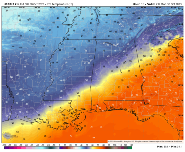
COLDEST AIR SO FAR: A sharp, well defined cold front is near the northwest corner of Alabama just before daybreak. It will move through the state today, setting the stage for falling temperatures over the northern half of the state with a very cool north wind. Temperatures will be in the 40s over the northern third of the state by mid afternoon, while South Alabama is close to 80.
Some patchy light rain is possible this morning as the cold air arrives over North Alabama, but amounts will be very light and very spotty, and certainly no drought buster.
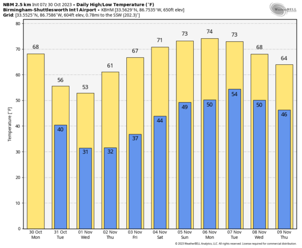
All of Alabama will be in the cold air tomorrow and Wednesday with highs in the 50s over the northern and central counties of the state, with low 60s to the south. A freeze warning has been issued for the northern half of Alabama for Wednesday morning… we expect lows in the 25-34 degree range with a clear sky and diminishing wind. Temperatures will drop into the upper 30s as far south as I-10 in far South Alabama. Thursday morning should be just as cold.
A warming trend begins Thursday afternoon, and by Friday highs will range from the 60s over North Alabama, to the low to mid 70s over the southern counties.
Other than the chance of patchy light rain today over the northern counties, the week will be dry. Lingering clouds will move out tomorrow morning, followed by sunny days and fair nights.
THE ALABAMA WEEKEND: The weekend will be dry with mostly sunny pleasant days and fair cool nights. Highs mostly in the 70s, lows in the 40s and 50s.
NEXT WEEK: Unfortunately the chance of any beneficial rain looks very small as this long dry spell continues. A new surge of cool air arrives by mid-week… See the video briefing for maps, graphics, and more details.
FIRE WEATHER WATCH: A fire weather watch has been issued for much of Alabama tomorrow and Wednesday. The combination of a dry air mass and windy conditions will result in critical fire weather conditions. No outdoor burning.
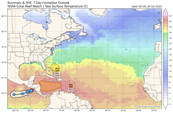
TROPICS: Satellite data indicate that the low pressure system (Invest 96L) located a couple of hundred miles east-northeast of the central Bahamas continues to produce an area of gale-force winds on its northeast side. However, the associated showers and thunderstorms remain disorganized. This system is moving into an area of strong upper-level winds and dry air, and the chances of it becoming a short-lived tropical storm appear to be decreasing. The low is expected to move slowly west-northwestward today and then turn northward and northeastward tomorrow and Wednesday.
And, an area of disturbed weather has formed over the eastern Caribbean Sea. This system is expected to move westward during the next several days, and environmental conditions appear conducive for gradual development. A tropical depression could form late this week when the system reaches the central or southwestern Caribbean Sea. NHC gives it a 40 percent chance of development; if anything does develop it will likely move into Central America.
No tropical systems are expected near the U.S. or the Gulf of Mexico for the next seven days.
ON THIS DATE IN 1991: The Perfect Storm, also known as the No-Name Storm reached maximum strength on this day with a low pressure of 972 mb and sustained winds of 69 mph. Damage from the storm totaled over $200 million and thirteen people were killed in total, six of which were an outcome of the sinking of Andrea Gail, which inspired the book and later movie, The Perfect Storm.
Look for the next video briefing here by 3:00 this afternoon… enjoy the day!
Category: Alabama's Weather, ALL POSTS, Weather Xtreme Videos


