Midday Nowcast: Clearing Sky with a Freeze Warning in Effect
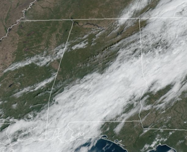
FREEZE WARNING: The coldest air so far this season is settling into Alabama today. Today and tomorrow and will feature highs in the 50s over the northern half of the state, with low 60s for the southern half of the state. It is a cool and breezy day and the sky will continue to clear through the afternoon.
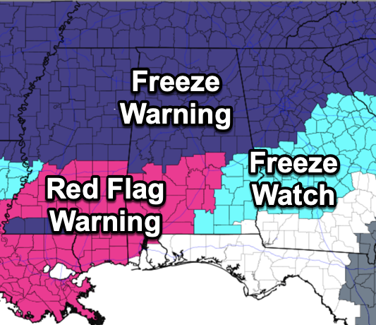
A freeze warning is in effect for the northern half of Alabama tonight, and a Freeze Watch as far south as the Alabama-Florida line tomorrow night; that will become a Freeze Warning tomorrow night. The next two nights should bring an end to the growing season across the state as we expect lows in the 26-36 degree range with a clear sky and diminishing wind.
THURSDAY THROUGH THE WEEKEND: After the freezing start to the state, a warming trend begins Thursday afternoon, and by Friday highs will range from the 60s over North Alabama, to the low to mid 70s over the southern counties. The weekend will be dry with mostly sunny pleasant days and fair cool nights. Highs mostly in the 70s, lows in the 40s and 50s.
FOOTBALL WEATHER: Expect a clear sky for the high school games across Alabama Friday night with temperatures falling through the 50s.
Saturday, UAB hosts Florida Atlantic at Protective Stadium in downtown Birmingham (2:00p CT kickoff). The sky will be sunny with temperatures in the low 70s.
Auburn travels to Nashville to take on Vanderbilt (3:00p CT kickoff)… the sky will be clear with upper 60s at kickoff, dropping into the low 60s by the final whistle.
And, Alabama will host LSU Saturday evening at Bryant-Denny Stadium (6:45p CT kickoff)… the sky will be clear with temperatures falling through the 60s. A perfect night for football in Tuscaloosa.
NEXT WEEK: The very nice, fall air will remain in place for much of next week as well. Unfortunately the chance of any beneficial rain the next 7-10 days looks very small as this long dry spell continues and the drought and fire weather dangers will continue. We do trend cooler towards the end of next week.
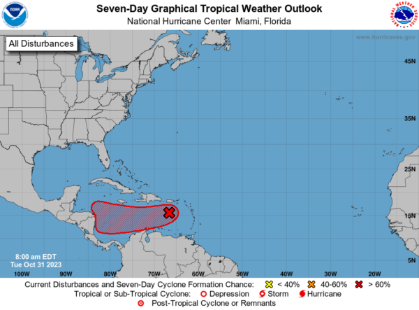
IN THE TROPICS: Just one feature we are watching currently. In the Eastern Caribbean Sea, Invest 97L is a trough of low pressure over the eastern Caribbean Sea is producing a large area of showers and thunderstorms. Environmental conditions appear conducive for further development during the next several days while the system moves westward over the central and southwestern Caribbean Sea, and a tropical depression is likely to form by the latter part of this week. Regardless of development, this system has the potential to produce heavy rains over portions of Central America towards the end of the week. Formation chance through 7 days…high…70 percent
Hurricane season ends November 30th and the remaining names on list this year are Vince and Whitney.
BEACH FORECAST CENTER: Get the latest weather and rip current forecasts for the beaches from Fort Morgan to Panama City on our Beach Forecast Center page. There, you can select the forecast of the region that you are interested in visiting.
WORLD TEMPERATURE EXTREMES: Over the last 24 hours, the highest observation outside the U.S. was 110.3F at Villamontes, Bolivia. The lowest observation was -75.8F Dome A, Antarctica.
CONTIGUOUS TEMPERATURE EXTREMES: Over the last 24 hours, the highest observation was 92F at Ochopee, FL. The lowest observation was -12F at Peter Sinks, UT.
Category: Alabama's Weather, ALL POSTS
About the Author (Author Profile)
Macon, Georgia Television Chief Meteorologist, Birmingham native, and long time Contributor on AlabamaWX. Stormchaser. I did not choose Weather, it chose Me. College Football Fanatic. @Ryan_StinnetSubscribe
If you enjoyed this article, subscribe to receive more just like it.


