A Few Showers This Afternoon/Tonight; Dry Weekend Ahead
COLD FRONT ON THE WAY: Clouds will increase across Alabama today, and we will mention a chance of showers for the northwest counties this afternoon, and statewide tonight ahead of a cold front. Moisture is limited, and rain amounts will be generally under one tenth of an inch. Showers will end after midnight, and a surge of dry air pushes into the state for the weekend.
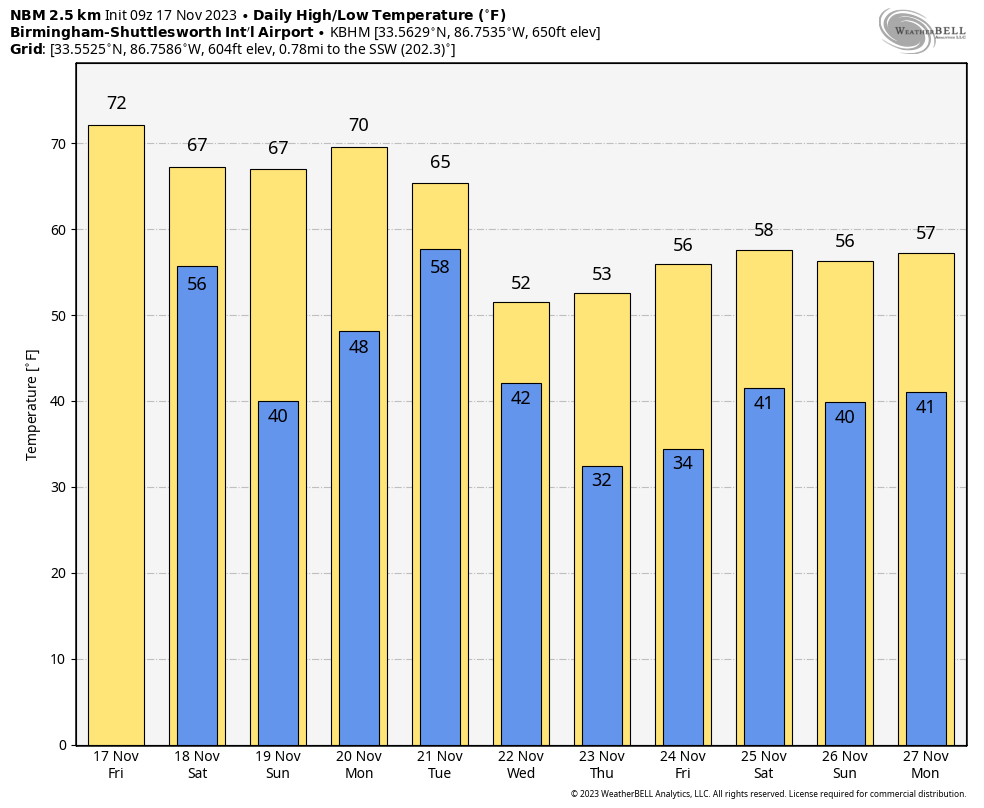
The sky becomes mostly sunny tomorrow with a high in the 60s over North Alabama, with 70s to the south. Sunday will be another sunny day with highs in the 65-75 degree range across the state.
NEXT WEEK: Global models continue to slow down the system that will impact our state early next week. Monday looks like a mild, dry day with a high in the 70s. Some rain could arrive after midnight, but it now looks like the bulk of the event will come during the day Tuesday.
This will be the most dynamic weather system we have experienced since the spring, and severe storms are possible west of Alabama Monday and Monday night. SPC has defined a risk from East Texas to South Mississippi.
However, for now, SPC has not put any part of Alabama in a formal severe weather risk on Tuesday. Trends are toward a weaker surface low and very limited surface based instability, which will keep the chance of severe storms fairly low. However, we need to get within the 60 hour window (when we can see high resolution, convectional allowing model data) before we can have great certainty about the details of how this one plays out. Just keep an eye on forecast updates over the weekend.
On the positive side, beneficial rain is likely Tuesday and Tuesday night, with amounts of 1-2 inches expected statewide. Drier air returns Tuesday night, and Wednesday will be a dry, colder day with a high in the 48-54 degree range over North Alabama, with mid to upper 50s for the southern half of the state.
THANKSGIVING/BLACK FRIDAY/IRON BOWL SATURDAY: Thanksgiving Day will be cold and dry with a good supply of sunshine. We start the day at or below freezing over the northern half of the state… the high will be in the 50s. Beyond that, forecast confidence drops. The next wave will likely bring rain back to the state either Friday or Saturday. The American GFS model suggests a rainy day Friday, followed by dry, cool weather for the Iron Bowl (Alabama at Auburn on Saturday November 25). However, the reliable European global model holds the rain off until Saturday. Once we get the Tuesday system out of here we will have a high confidence look at that weekend.
See the video briefing for maps, graphics, and more details.
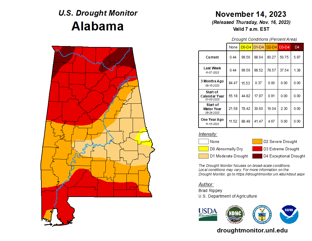
DROUGHT MONITOR: The new drought monitor released yesterday shows 99.56 percent of Alabama in a drought. A D4 “exceptional drought” is defined for part of Northeast and Northwest Alabama; a D3 “extreme drought” extends down to Tuscaloosa, Birmingham, and Gadsden… as well as parts of South Alabama.
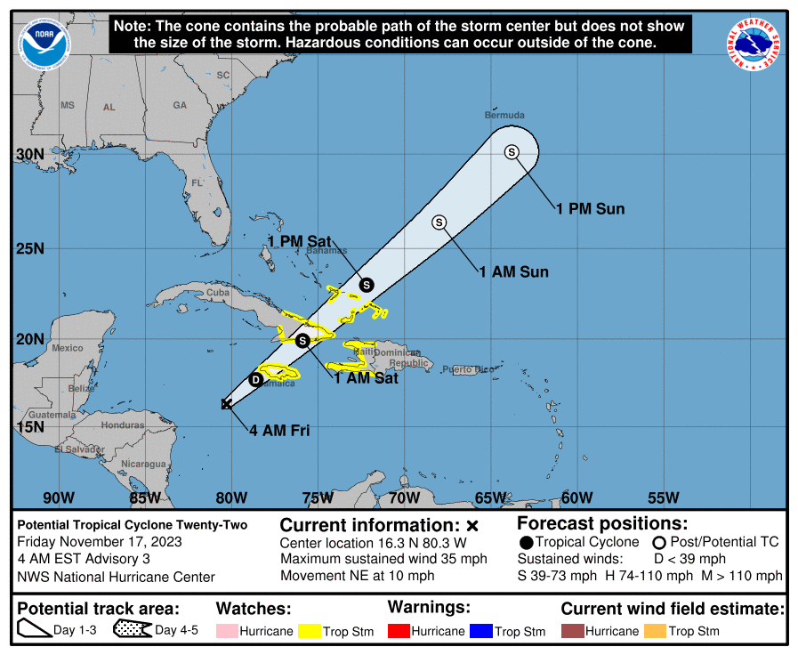
TROPICS: Potential Tropical Cyclone 22 is in the Caribbean; it has a chance of becoming a tropical depression or storm later today or tonight. The latest global model guidance depicts that the system may fail to consolidate convection and remaining elongated as southwesterly vertical wind shear begins to increase, stretching the convective structure. Although the model guidance has trended towards a less organized system, there remains a brief window of opportunity for the system to become a tropical cyclone. The official NHC forecast depicts that the disturbance could become short-lived tropical cyclone while it moves into the west-central Caribbean and near the Bahamas.
Regardless of tropical cyclone formation, the most significant hazard from this system is expected to be heavy rainfall, especially in areas of higher terrain, across portions of Jamaica, southeastern Cuba, and Hispaniola.
The rest of the Atlantic basin is quiet; the hurricane season ends at the end of this month.
FOOTBALL WEATHER: For the high school playoff games tonight across Alabama, the sky will be mostly cloudy, and a few widely scattered showers can’t be ruled out. Nothing widespread, and many stadiums will be dry. Temperatures will fall slowly through the 60s.
Tomorrow, Alabama hosts Chattanooga at Bryant-Denny Stadium (11a CT kickoff)… after some early morning clouds, the sky should be mostly sunny during the game with temperatures rising from near 64 at kickoff to 68 degrees by the final whistle.
UAB will host Temple at Protective Stadium in Birmingham (2p CT kickoff)… it will be a sunny afternoon with temperatures hovering in the mid to upper 60s.
And, Auburn will host New Mexico State at Jordan-Hare Stadium (3p CT kickoff)… the sky will be sunny. Expect a kickoff temperature near 67 degrees, falling into the low 60s by the end of the game.
ON THIS DATE IN 1927: A tornado (at times to 260 yards wide) cut a seventeen-mile path through Alexandria, Virginia across the District of Columbia from the Navy yard to Benning Rd. & 19th St. NE and Northeast to East Riverdale, Maryland. This storm injured 31 people. The tornado struck the Naval Air Station where a wind gust of 93 mph was recorded.
Look for the next video briefing here by 3:00 this afternoon… enjoy the day!
Category: Alabama's Weather, ALL POSTS, Weather Xtreme Videos
About the Author (Author Profile)
James Spann is one of the most recognized and trusted television meteorologists in the industry. He holds the AMS CCM designation and television seals from the AMS and NWA. He is a past winner of the Broadcast Meteorologist of the Year from both professional organizations.Subscribe
If you enjoyed this article, subscribe to receive more just like it.


