Midday Nowcast: Front on the Way; Great Weekend Weather
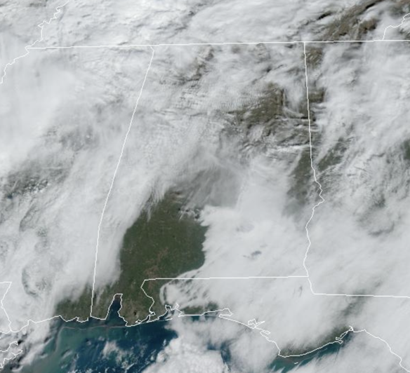
An approaching cold front will keep the clouds and the chance of showers in the forecast the rest of today and into tonight, so keep the rain gear close. Highs today are in the 60s and 70s for most locations. Showers will come to an end late tonight as the front pushes out of the state. Lows tonight will be in the 50s.
FRIDAY NIGHT FOOTBALL: For those high school playoff games tonight, most stadiums will be dry, but some showers will be possible. It will remain mainly cloudy with temperatures falling through the 60s.
WONDERFUL WEEKEND WEATHER: Tomorrow will feature some morning clouds, but as the sky clears, most of the weekend will be great with dry and mainly sunny weather, and highs generally in the low to mid 60s. Nights will be clear and chilly, with lows in the upper 30s and lower 40s.
FOOTBALL FORECAST: Tomorrow, Alabama hosts Chattanooga at Bryant-Denny Stadium (11a CT kickoff)… after some early morning clouds, the sky should be mostly sunny during the game with temperatures rising from near 64 at kickoff to 68 degrees by the final whistle.
UAB will host Temple at Protective Stadium in Birmingham (2p CT kickoff)… it will be a sunny afternoon with temperatures hovering in the mid to upper 60s.
And, Auburn will host New Mexico State at Jordan-Hare Stadium (3p CT kickoff)… the sky will be sunny. Expect a kickoff temperature near 67 degrees, falling into the low 60s by the end of the game.
INTO NEXT WEEK: For the second half of the week, not much change in the forecast, as both the European and GFS American model continue to show Thanksgiving Eve, Thanksgiving, Black Friday, and Iron Bowl Saturday will be dry for Alabama, but it will be chilly with highs in the 50s and lows in the 30s.
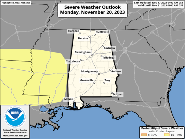
Now for the early week system, the models are showing better agreement with the timing and are slowing the system down by about twelve hours. The SPC has shifted the severe weather threat on Monday back to the west, due to this timing change.
Monday will feature increasing clouds with highs approaching 70° with a few scattered showers possible. As the front approaches the state, rain and storms will be increasing late Monday night and into Tuesday. At this time, no part of Alabama is highlighted in a severe weather threat, but of course that could change in the coming days. A lot of the threat for Alabama will be determined by how far north the warm front makes it. For now, we will mention widespread rain and storms, with a few strong storms possible, especially over southern portions of the state on Tuesday. Just know, the forecast will continue to evolve over the next few days.
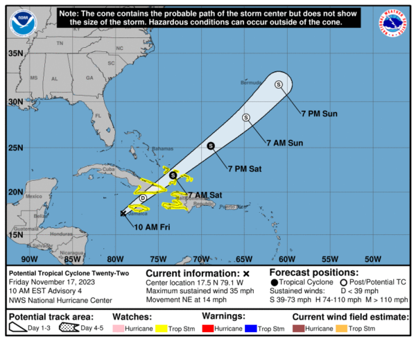
IN THE TROPICS: Soon to be Vince? Potential Tropical Cyclone 22 remains in the Caribbean and this system is moving toward the northeast near 14 mph, and an additional acceleration toward the northeast is expected through the weekend. On the forecast track, the system is expected to move across Jamaica later today, southeastern Cuba by early Saturday, and the southeastern Bahamas and Turks and Caicos Islands on Saturday. Maximum sustained winds are near 35 mph with higher gusts. Some slight strengthening is possible during the next couple of days, but the system’s chance of becoming a tropical cyclone appears to be decreasing. Formation chance through 7 days…medium…40 percent. The estimated minimum central pressure is 1004 mb (29.65 inches).
Hurricane season ends November 30th and the remaining names on list this year are Vince and Whitney.
BEACH FORECAST CENTER: Get the latest weather and rip current forecasts for the beaches from Fort Morgan to Panama City on our Beach Forecast Center page. There, you can select the forecast of the region that you are interested in visiting.
WORLD TEMPERATURE EXTREMES: Over the last 24 hours, the highest observation outside the U.S. was 110.8F at Fitzroy Crossing, Australia. The lowest observation was -68.1F Dome A, Antarctica.
CONTIGUOUS TEMPERATURE EXTREMES: Over the last 24 hours, the highest observation was 84F at Florida City, Florida. The lowest observation was 7F at Peter Sinks, UT.
Category: Alabama's Weather, ALL POSTS


