Midday Nowcast: A Cool Travel Day Across Alabama
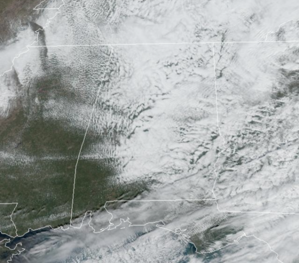
An upper low is swinging through the state today causing it to be a mostly cloudy and colder day with highs in the 50s. A few sprinkles are possible under the upper low over the northern third of the state, but most of the state will remain dry. The sky should begin to clear later today.
TURKEY DAY: Thanksgiving Day will start of cold with upper 30s and low 40s, by the afternoon highs will be in the 50s and 60s for most of the state. Late tomorrow, clouds will increase as a feature in the northern Gulf of Mexico could bring some scattered light rain to the southern counties of Alabama tomorrow night into Friday morning.
BLACK FRIDAY: Some lingering showers are expected Friday morning down south, but thought the day we should start to see more sunshine across the northern half of the state. It will be another cool day with highs mainly in the 50s over the northern half of the state.
WEEKEND WEATHER: Cool, dry weather continues over the weekend. The sky will be mostly sunny Saturday; some clouds will move in on Sunday with an upper air feature, but the low levels will be dry and we are keeping the forecast dry. Afternoon highs will hold be in the upper 50s to mid 60s this weekend, while nights will be mainly be in the 40s, not far from average values for late November in Alabama.
IRON BOWL: The weather will be just about perfect for Saturday’s Iron Bowl in Auburn (Alabama at Auburn; 2:30p CT kickoff). The sky will be mostly sunny with a kickoff near 63 degrees, falling into the 50s by the fourth quarter.
NEXT WEEK: A new surge of cooler air will arrive Monday, and at this point all of next week looks dry with highs mostly in the 50s and lows in the 30s. A freeze is likely over the northern half of the state during the early morning hours Tuesday through Friday. No signs of a significant rain or storms for Alabama the next 7-10 days.
IN THE TROPICS: Still one area the NHC is monitoring, for possible development. Hurricane season officially ends at the end of the month.
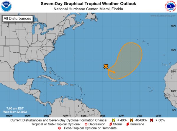
In the Central Subtropical Atlantic, an area of low pressure is expected to develop along a frontal boundary over the central subtropical Atlantic in a day or so. This non-tropical low is forecast to move southeastward across the central subtropical Atlantic over warmer sea surface temperatures during the next few days, and environmental conditions could allow for this system to gradually acquire tropical or subtropical characteristics. A subtropical or tropical storm could form by the latter part of this week or this weekend, as the system turns northeastward by the weekend. Formation chance through 7 days…medium…50 percent.
BEACH FORECAST CENTER: Get the latest weather and rip current forecasts for the beaches from Fort Morgan to Panama City on our Beach Forecast Center page. There, you can select the forecast of the region that you are interested in visiting.
WORLD TEMPERATURE EXTREMES: Over the last 24 hours, the highest observation outside the U.S. was 113.2F at Garoua, Cameroon. The lowest observation was -64.5F Dome A, Antarctica.
CONTIGUOUS TEMPERATURE EXTREMES: Over the last 24 hours, the highest observation was 89F at Tampa, FL. The lowest observation was -6F at Peter Sinks, UT.
Category: Alabama's Weather, ALL POSTS
About the Author (Author Profile)
Macon, Georgia Television Chief Meteorologist, Birmingham native, and long time Contributor on AlabamaWX. Stormchaser. I did not choose Weather, it chose Me. College Football Fanatic. @Ryan_StinnetSubscribe
If you enjoyed this article, subscribe to receive more just like it.


