Midday Nowcast: Sunny Days Before a Very Wet Weekend
Plenty of sunshine in the Alabama sky today, but despite the sunshine, it remains chilly outside with afternoon temperatures ranging from the upper 40s to mid 50s across the northern half of the state. Tonight, will be a very cold one with a widespread freeze for nearly the entire state. We expect low to mid 20s for much of the state.
Tomorrow, a gradual warming trend begins as temperatures surge back into the upper 50s and lower 60s under a mainly sunny sky. Thursday should feature mainly 60s, and it will remain dry for the day, but clouds begin to increase late Thursday, and rain is likely across Alabama late Thursday night into Friday morning.
WET IS THE WORD: A welcomed and much needed wet period is ahead for Alabama as multiple rounds of rain and storms should soak the state Friday morning, through the weekend, and even into Monday. The first round of rain will come from about midnight Thursday night through 12:00 noon Friday. The rain should come to a temporary pause Friday afternoon, but clouds will linger with highs in the 60s.
Over the weekend, we will have more rounds of rain. The weekend won’t be a total washout, but occasional rain is likely, and the rain cold be heavy at times, especially over South Alabama. A few thunderstorms are possible, but for now severe storms look unlikely. If there are storms, these should be confined to southern portions of the state. Highs will be in the mid to upper 60s both Saturday and Sunday. The rain should linger into Monday before drier air returns Tuesday.
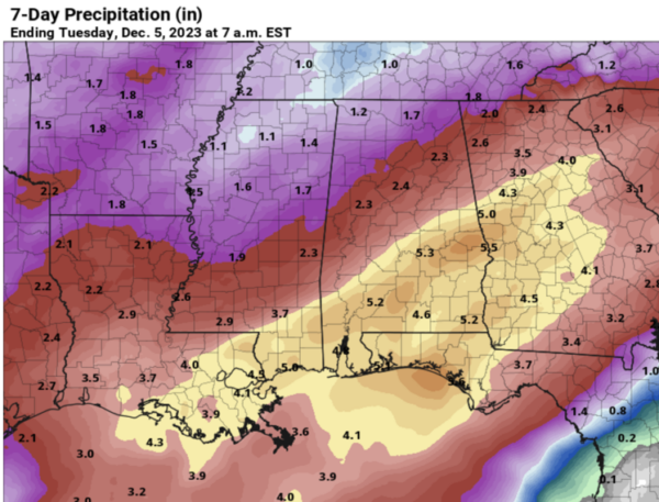
POTENTIAL RAINFALL: South Alabama has the potential for 3-5 inches of rain through Monday night, with 1-3 inches over the northern half of the state. Very beneficial rain considering the ongoing drought. It won’t completely wipe out the drought conditions, but it will certainly help, and should go a long ways in replenishing ground water levels, as well as bringing lake and stream levels back up.
NEXT WEEK: After the rain exits Monday, much of next week looks relatively quiet and dry. However, the last few global model runs are suggesting a quick hitting cold blast moves through the Southeast. For now, we will stick with highs in the 50s, and lows mainly in the 30s and 40s, but these temperatures could be adjusted downward in future forecasts.
IN THE TROPICS: All is quiet across the Atlantic basin and hurricane season officially ends on Thursday.
BEACH FORECAST CENTER: Get the latest weather and rip current forecasts for the beaches from Fort Morgan to Panama City on our Beach Forecast Center page. There, you can select the forecast of the region that you are interested in visiting.
WORLD TEMPERATURE EXTREMES: Over the last 24 hours, the highest observation outside the U.S. was 116.1F at Augrabies Falls, South Africa. The lowest observation was -62.3F Dome A, Antarctica.
CONTIGUOUS TEMPERATURE EXTREMES: Over the last 24 hours, the highest observation was 82F at Ochopee, FL. The lowest observation was -31F at Peter Sinks, UT.
Category: Alabama's Weather, ALL POSTS
About the Author (Author Profile)
Macon, Georgia Television Chief Meteorologist, Birmingham native, and long time Contributor on AlabamaWX. Stormchaser. I did not choose Weather, it chose Me. College Football Fanatic. @Ryan_StinnetSubscribe
If you enjoyed this article, subscribe to receive more just like it.


