Rain Returns Late Tomorrow Night; Wet At Times Friday/Saturday
FRIGID START: For most of Alabama this is the coldest morning so far this season. Here are some temperatures just before sunrise…
Tuckers Chapel (Cherokee County) 17
Gadsden 18
Fort Payne 18
Ashville 18
Margaret 19
Haleyville 20
Jasper 21
Pell City 21
Chelsea 21
Hueytown 21
Decatur 23
Anniston 23
Muscle Shoals 23
Trussville 23
Huntsville 24
Birmingham 26
Greenville 26
Montgomery 27
Northport 27
Tuscaloosa 27
Auburn 29
Ozark 29
Dothan 32
Mobile 33
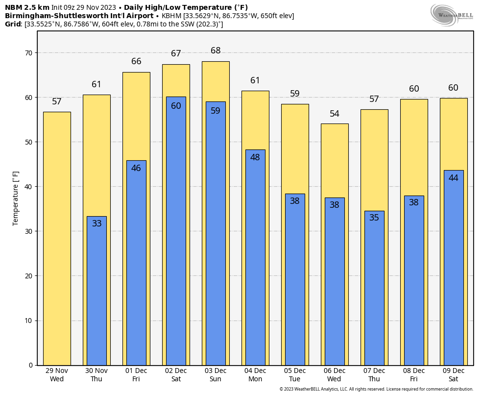
Today will be another mostly sunny day with a high in the 50s over North Alabama, with 60s for the southern counties of the state. Another freeze is likely for some early tomorrow, then we will have a warming trend through the weekend.
Tomorrow will be dry with a partly sunny sky, but rain returns to the state late tomorrow night, generally after 10:00 p.m.
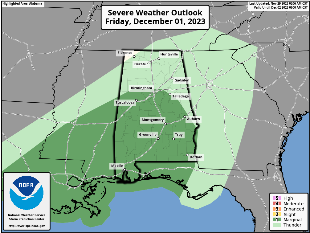
FRIDAY AND THE WEEKEND: The weather will be wet and unsettled with multiple waves of rain and a few thunderstorms. SPC has defined a low end “marginal risk” (level 1/5) of severe thunderstorms for the southern 2/3 of Alabama Friday; there could be sufficient instability for a few storms with gusty winds during the afternoon and evening hours.
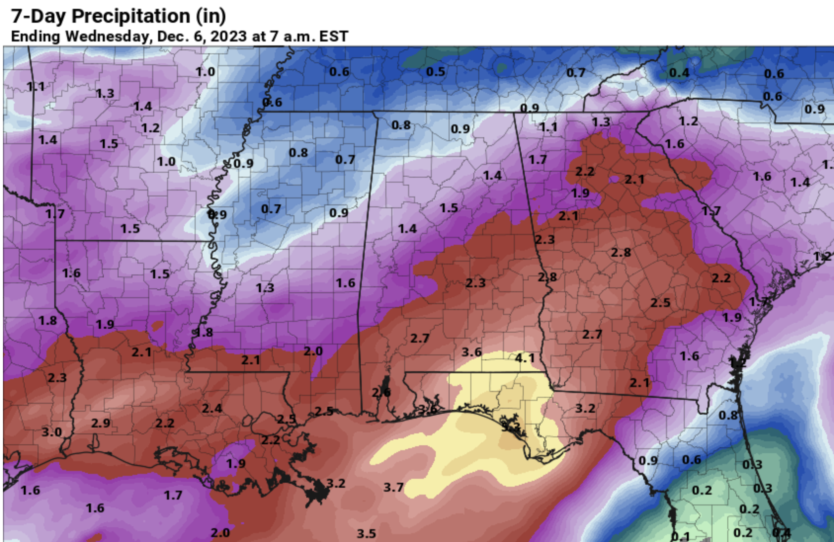
Occasional rain will continue Saturday and Saturday night, with potential for some thunder. The rain will likely end early Sunday morning, and drier air moves in by Sunday afternoon/night. Rain potential tomorrow night through Sunday will be around 4 inches for the southeast corner of the state… 2-3 inches for the southern counties, 1-2 inches for places like Birmingham/Tuscaloosa/Anniston/Gadsden, and around one inch for the Tennessee Valley of North Alabama.
Expect highs in the 65-70 degree range over the weekend with very little sun.
NEXT WEEK: For now the weather next week looks dry with seasonal temperatures… highs in the 50s and 60s, with lows in the 30s and 40s. See the video briefing for maps, graphics, and more details.
FOOTBALL WEATHER: For the high school playoff games Friday night, rain is possible statewide, but most likely over the southern counties. Temperatures will be in the 50s.
For fans headed to Saturday’s SEC Championship game in Atlanta (Alabama vs Georgia, 3p CT kickoff)… the game is being played at Mercedes-Benz Stadium under the dome, but outside the stadium rain is likely with temperatures in the low to mid 60s.
TROPICS: The Atlantic basin is quiet, and hurricane season ends tomorrow.
ON THIS DATE IN 1991: A tornado struck southeast Springfield, Missouri, causing F4 damage. Shortly after touchdown, the tornado reached F3 intensity, approximately 3 miles north of the town of Nixa. While crossing Highway 65, the tornado picked up a truck and dropped it onto a frontage road, killing one passenger and injuring ten others. The tornado intensified to F4 strength as it moved through the Woodbridge and Natural Bridge Estates subdivisions where 15 homes were destroyed. Altogether, two people were killed and 64 others were injured.
ON THIS DATE IN 2022: Several tornadoes touched down across Alabama, including an EF-3 that began in Greene County, MS and lifted in Washington County (in Southwest Alabama).
Look for the next video briefing here by 3:00 this afternoon… enjoy the day!
Category: Alabama's Weather, ALL POSTS, Weather Xtreme Videos
About the Author (Author Profile)
James Spann is one of the most recognized and trusted television meteorologists in the industry. He holds the AMS CCM designation and television seals from the AMS and NWA. He is a past winner of the Broadcast Meteorologist of the Year from both professional organizations.Subscribe
If you enjoyed this article, subscribe to receive more just like it.


