Midday Nowcast: Sunny Thursday; Stormy Weekend
After the freezing start, today is warmer with highs in the upper 50s and lower 60s under a sky full of sunshine. Clouds begin to increase tomorrow and highs should surge well into the 60s. A few showers are possible late tomorrow and tomorrow night across the state.
CHAMPIONSHIP FOOTBALL: For the “Super 7” high school championship games in Tuscaloosa at Bryant-Denny Stadium dry weather continues through tomorrow. Temperatures will peak around 60 degrees today, then falling back into the 40s for the games tonight. The high tomorrow will be in the mid 60s with a partly sunny sky. We will mention the chance of a few isolated showers tomorrow night during the 6A game between Clay-Chalkville and Saraland, but nothing heavy or widespread. Temperatures will be in the 50s tomorrow night.
WEEKEND RAN AND STORMS: Saturday will be mainly cloudy, very breezy, with scattered showers and temperatures are likely to surge into the upper 60s and lower 70s ahead of the dynamic storm system to our west which will impact Alabama late Saturday night.
The SPC maintains a risk of severe thunderstorms Saturday, especially west of Alabama, but the Saturday severe weather risk outlook is valid until 6AM Sunday, and the SPC has extended a “marginal risk” (level 1 of 5) into the western half of Alabama, along and west of Interstate 65 for the overnight hours Saturday into early Sunday morning.
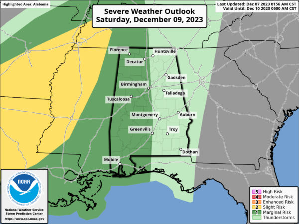
An organized batch of rain and thunderstorms will arrive late Saturday night/Sunday morning ahead of the cold front. The storm system has a positive tilt upper trough and generally unidirectional wind profiles. Factor those in with limited surface based instability, and the overall severe weather threat will be low for Alabama. Strong storms could produce gusty winds early Sunday morning during the pre-dawn hours. A brief, isolated tornado can’t be ruled out, but isn’t likely. The window for the heavier storms will come from about midnight Saturday night through 9AM Sunday. The rain will end from west to east during the day Sunday as colder air rolls into the state. It will be a blustery day and temperatures will hold in the 40s over North Alabama, with 50s for South Alabama. The sky will begin to clear by late afternoon.
Rain amounts of 1-2 inches are expected for most of Alabama with this event which will certainly be a welcome sight for a drought stricken state.

INTO NEXT WEEK: Below average temperatures highlight the forecast for much of next week as a cooler and dry air mass settles into the state. Highs will be in the 50s, while lows will be in the 30s. Most of next week looks day as well.
BEACH FORECAST CENTER: Get the latest weather and rip current forecasts for the beaches from Fort Morgan to Panama City on our Beach Forecast Center page. There, you can select the forecast of the region that you are interested in visiting.
WORLD TEMPERATURE EXTREMES: Over the last 24 hours, the highest observation outside the U.S. was 115.7F at Marree Aero, Australia. The lowest observation was -67.2F Ojmjakon, Russia.
CONTIGUOUS TEMPERATURE EXTREMES: Over the last 24 hours, the highest observation was 86F at Ogilby, CA. The lowest observation was -8F at Berlin, NH.
Category: Alabama's Weather, ALL POSTS
About the Author (Author Profile)
Macon, Georgia Television Chief Meteorologist, Birmingham native, and long time Contributor on AlabamaWX. Stormchaser. I did not choose Weather, it chose Me. College Football Fanatic. @Ryan_StinnetSubscribe
If you enjoyed this article, subscribe to receive more just like it.


