Rain/Storms Return To Alabama Over The Weekend
COLD START: Here are some temperatures across Alabama just before sunrise…
Gadsden 24
Fort Payne 25
Jasper 25
Chelsea 26
Talladega 26
Haleyville 27
Trussville 27
Cullman 28
Good Hope 29
Evergreen 29
Anniston 29
Demopolis 29
Decatur 30
Tuscaloosa 30
Montgomery 30
Muscle Shoals 31
Troy 31
Birmingham 32
Huntsville 32
Mobile 35
Dothan 36
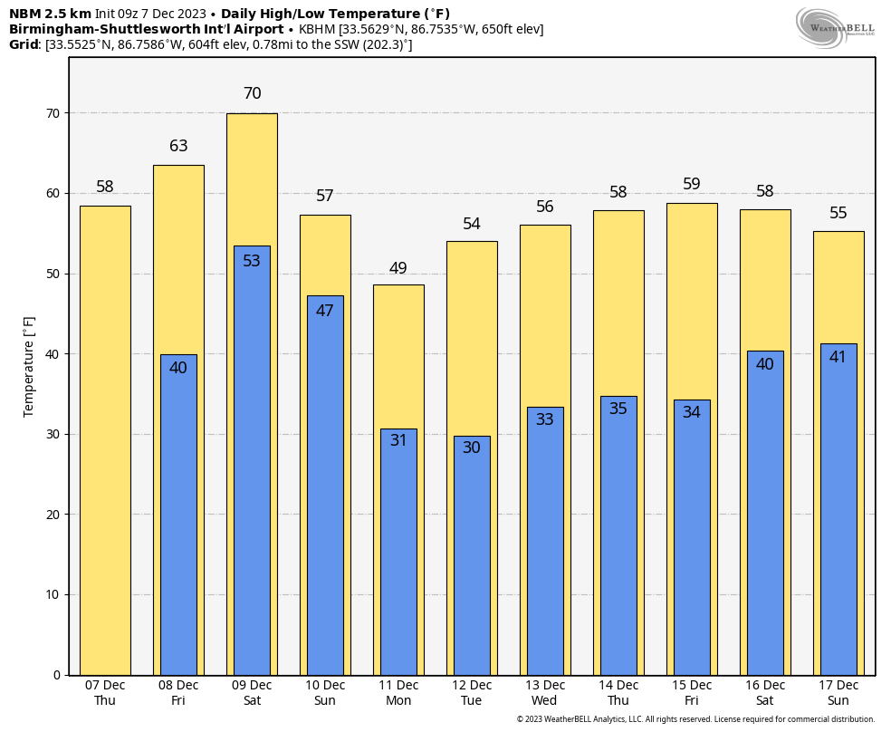
Today will feature a sunny sky with a high in the 57-65 degree range this afternoon. Temperatures reach the 60s statewide tomorrow afternoon with a partly sunny sky. We will introduce the chance of a few showers near the Gulf Coast during the day tomorrow, and scattered showers are possible across all of Alabama tomorrow night as moisture begins to move northward.
WET/STORMY WEEKEND: Showers are possible statewide during the day Saturday with the approach of a storm system. Understand it won’t rain all day, but a few passing showers are likely. The day will be mild and breezy with a high between 68 and 74 degrees… about ten degrees above average for early December in Alabama.
An organized batch of rain and thunderstorms will arrive late Saturday night into Sunday morning. SPC has introduced a “marginal risk” of severe thunderstorms for the western half of Alabama in their Day 3 outlook, which is valid through 6:00 a.m. Sunday.
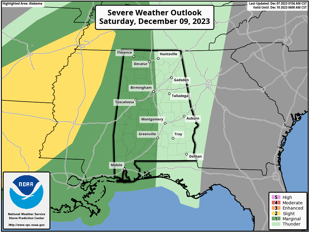
The storm system will feature a positive tilt upper trough, limited surface based instability, and generally unidirectional wind profiles. This means a fairly low end severe weather threat; heavier storms could produce gusty winds early Sunday morning during the pre-dawn hours. A brief, isolated tornado can’t be ruled out, but isn’t likely. The window for the heavier storms will come from about midnight Saturday night through 9:00 a.m. Sunday.
Own the positive side, rain amounts of 1-2 inches are expected for most of Alabama with this event. The rain will end from west to east during the day Sunday as colder air rolls into the state. Temperatures will hold in the 40s over North Alabama, with 50s for South Alabama. The sky will begin to clear by late afternoon.
NEXT WEEK: For now the week looks cool and dry with highs mostly in the 50s, and lows in the 30s. Many North Alabama communities will experience a freeze Monday, Tuesday, and Wednesday morning… See the video briefing for maps, graphics, and more details.
FOOTBALL WEATHER: For the “Super 7” high school championship games in Tuscaloosa at Bryant-Denny Stadium dry weather continues through tomorrow. Temperatures will peak around 60 degrees today, then falling back into the 40s for the games tonight. The high tomorrow will be in the mid 60s with a partly sunny sky. We will mention the chance of a few isolated showers tomorrow night during the 6A game between Clay-Chalkville and Saraland, but nothing heavy or widespread. Temperatures will be in the 50s tomorrow night.
ON THIS DATE IN 2004: An F2 tornado moved through parts of Lowndes County, MS and Lamar County, AL. The most significant damage was at Steens, MS where several homes were destroyed.
ON THIS DATE IN 2006: A rare tornado tore through Kensal Rise in London. This T4 on the TORRO scale, equivalent to an F2 on the Fujita scale, injured six people and damaged 150 homes. According to the BBC, the last tornado which caused significant damage in London was in December 1954, in West London.
Look for the next video briefing here by 3:00 this afternoon… enjoy the day!
Category: Alabama's Weather, ALL POSTS, Weather Xtreme Videos
About the Author (Author Profile)
James Spann is one of the most recognized and trusted television meteorologists in the industry. He holds the AMS CCM designation and television seals from the AMS and NWA. He is a past winner of the Broadcast Meteorologist of the Year from both professional organizations.Subscribe
If you enjoyed this article, subscribe to receive more just like it.


