

Strong Storms Arrive Tomorrow Night
WARMER: Temperatures are mostly in the 60s across Alabama this afternoon with a mix of sun and clouds; we note a few small showers/sprinkles over the southern quarter of the state. We will mention the chance of a few isolated showers statewide tonight as moisture levels continue to rise.

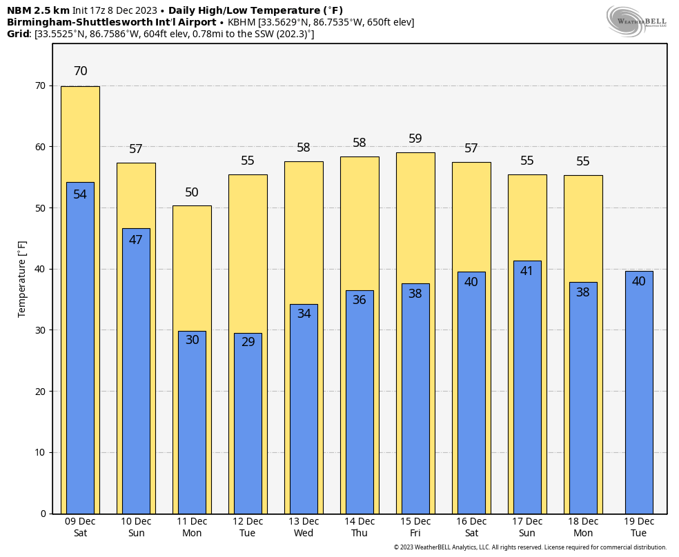
WET WEEKEND: A dynamic storm system will push rain and storms into Alabama over the weekend. Our forecast will include the chance of a few scattered showers tomorrow, but a decent part of the day will be dry. The sky will feature more clouds than sun, and temperatures reach the low 70s in many places by afternoon. An organized band of thunderstorms will arrive tomorrow night; SPC has defined a “slight risk” (level 2/5) of severe thunderstorms for the northwest counties of the state, and a “marginal risk” (level 1/5) for most of the rest of Alabama.
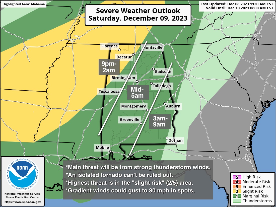
A positive tilt to the upper trough, limited surface based instability, and marginal SRH (storm relative helicity) values should help to keep the overall severe weather threat limited. Here are the key messages for the storms tomorrow night…
*The main risk for strong to severe thunderstorms across Alabama will come from around 9:00 tomorrow night through 6:00 a.m. Sunday. A few storms could linger across Southeast Alabama through mid-morning Sunday.
*The primary threat will come from strong, gusty thunderstorm winds. A brief, isolated tornado can’t be ruled out, especially in the “slight risk” across Northwest Alabama, but it isn’t likely.
*Gradient winds (not related to thunderstorms) out of the south will average 15-25 mph, with possible gusts to 30 mph before the line of storms passes through.
*Rain amounts will be in the 1-2 inch range for much of the state.
Rain will end from northwest to southeast Sunday morning. Much colder air rolls into the state Sunday; temperatures will settle into the 40s over the northern 2/3 of the state and stay there through the day. A brisk northeast wind will make it feel colder… the sky should be to clear by mid to late afternoon.
NEXT WEEK: The weather looks through the week with highs in the 50s, and low mostly in the 30s. A freeze is likely for North Alabama Monday and Tuesday morning… See the video briefing for maps, graphics, and more details.
FOOTBALL WEATHER: One final “Super 7” high school championship game will be played in Tuscaloosa at Bryant-Denny Stadium tonight; the 6A game between Clay-Chalkville and Saraland. The sky will be most cloudy with just an outside risk of a brief shower during the game. Temperatures will be in the 50s.
ON THIS DATE IN 1935: From the Monthly Weather Review for December 1935, “The outstanding flood of December 1935 was the record-breaking overflow of Buffalo and White Oak Bayous at Houston, Texas on the 8 and 9th. This destructive flood was caused by excessive rainfall over Harris County, Texas during a 42 hour period on the 6th, 7th, 8th, with amounts ranging from 5.50 inches at Houston” to 16.49 inches at the Humble Oil Company in the northwestern part of Harris County.
ON THIS DATE IN 2017: Significant snow fell across a large portion of Central Alabama along a southwest-to-northeast axis. This snow fell from December 8th into December 9th. Within the main corridor of snow, totals of 4 to 8 inches were common, with a few swaths of 8 to 12 inches. A few reports exceeding 12 inches were received from Clay into Cleburne Counties: one 15 inch report in Delta (Clay Co.), and two 13 inch reports (Cleburne Co.). While public reports are considered unofficial, values were fairly consistent and tend to indicate this event was a top-tier ranking snowstorm for some locations in East Alabama. Birmingham officially recorded 4 inches of snow, making it the 3rd snowiest December on record.
Look for my next video briefing here by 6:00 a.m. Monday… enjoy the weekend!
Category: Alabama's Weather, ALL POSTS, Weather Xtreme Videos
About the Author (Author Profile)
James Spann is one of the most recognized and trusted television meteorologists in the industry. He holds the AMS CCM designation and television seals from the AMS and NWA. He is a past winner of the Broadcast Meteorologist of the Year from both professional organizations.Subscribe
If you enjoyed this article, subscribe to receive more just like it.


