Dry, Calm Weather Through Friday For Alabama
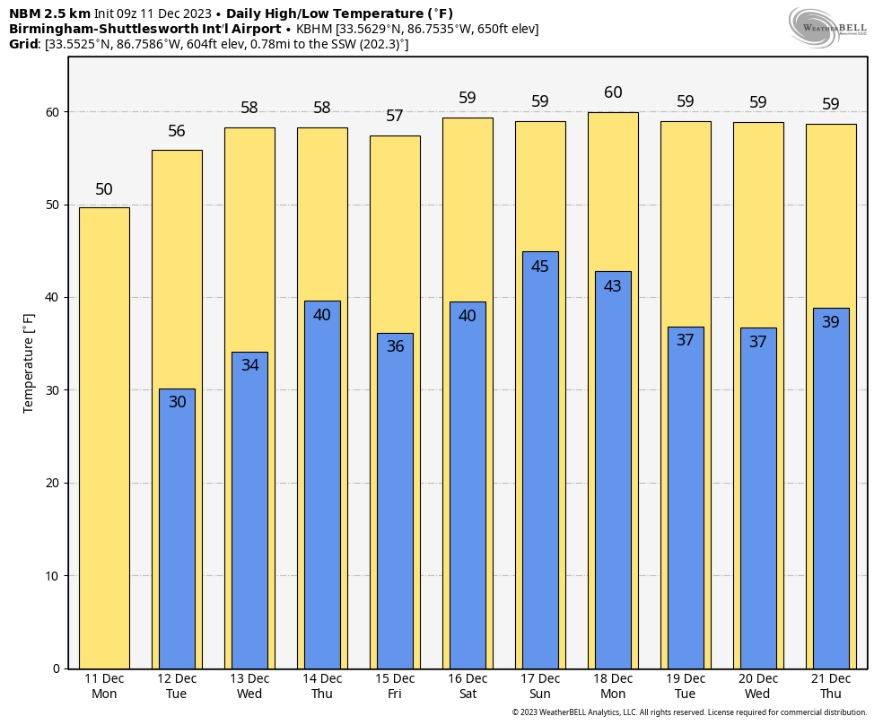
DRY DAYS: After the weekend rain and storms, we will enjoy a calm stretch of days this week with dry air in place. This morning temperatures are in the 25-35 degree range across Alabama; expect a high toady in the 50s with a good supply of sunshine. Another freeze is likely early tomorrow morning for the northern half of the state.
Look for mostly sunny cool days and fair chilly nights tomorrow through Friday… highs will be somewhere between 55 and 65, with lows in the 30s and 40s.
THE ALABAMA WEEKEND: This is a considerable amount of uncertainty concerning the weekend weather in Alabama due to big differences in global model output. A surface low is expected to form in the northern Gulf of Mexico, and at this point it looks like the best chance of rain will come over the southern half of the state. Higher probabilities are Saturday night and Sunday… we will have much better clarity by mid-week. Rain amounts are expected to be 1/2 inch or less for South Alabama, and no severe storms are expected. Highs for the weekend will be close to 60 degrees for most places.
NEXT WEEK: At this point the weather looks generally dry December 18-22 with seasonal temperatures. And, the long range guidance suggests temperatures will be a little above average around Christmas, not good news for those dreaming of a white Christmas… See the video briefing for maps, graphics, and more details.
NWS SURVEY RESULTS: NWS Birmingham was able to identity two brief tornadoes late Saturday night, between midnight and 12:30 a.m. The first was an EF-1 with winds of near 100 mph that moved from near I-65 at Wildwood Parkway to just west of Samford University. The second was another EF-1 that moved from near Brookwood Mall into Mountain Brook. They will have track maps and more specific information later today.
Both of these happened with no well defined tornado signature on radar, and accordingly no tornado warnings were in effect. However, a severe thunderstorm warning was in effect; the first warning for Southwest Jefferson County was issued at 11:12pm, the second one for the rest of Jefferson County at 11:59 p.m.
NWS will survey potential tornado damage in southern Lee and southern Barbour counties today.
WEEKEND RAIN TOTALS: Here are some rain totals over the weekend across Alabama…
Good Hope 2.40″
Crestwood 2.32″
Oxmoor Valley 2.19″
Birmingham Airport 2.08″
Tuscaloosa 1.24″
Jemison 1.24″
Egypt (near Gadsden) 1.13″
Gardendale 1.12″
Remlap 1.54″
Huntsville .85″
Muscle Shoals .73″
Mobile .68″
Decatur .63″
Anniston .51″
Dothan .42″
Montgomery .32″
ON THIS DATE IN 1905: The highest temperature ever recorded in South America was recorded at Rivadavia, Argentina with a temperature of 120 degrees.
ON THIS DATE IN 1961: A tornado moved through Jacksonville in East Alabama; it produced significant damage on the campus of Jacksonville State University, but there were no injuries.
Look for the next video briefing here by 3:00 this afternoon… enjoy the day!
Category: Alabama's Weather, ALL POSTS, Weather Xtreme Videos
About the Author (Author Profile)
James Spann is one of the most recognized and trusted television meteorologists in the industry. He holds the AMS CCM designation and television seals from the AMS and NWA. He is a past winner of the Broadcast Meteorologist of the Year from both professional organizations.Subscribe
If you enjoyed this article, subscribe to receive more just like it.


