Dry and Cool For Much of the Rest of 2023
Parts of Alabama picked up highly beneficial rains on Christmas Eve and Christmas morning. The I-59 Corridor southwest and I-20 over to Anniston were the big winners, picking up between 1.5 and 2 inches of rain. Shuttlesworth Birmingham International Airport was one of the big winners with 2.08 inches of rain. I picked up 1.63 inches at my location in southern Jefferson County near the Acton Road. Hopefully, this will put a dent in the Drought Monitor report that will come out Thursday. Certainly, the area from Birmingham to Fort Payne that is in D3 Extreme Drought. Still, for the year, BHM is 6.95 inches below normal. Not much time to make that up, and certainly not much rain in the forecast. Let’s dig into the details.
ON THE WEATHER MAPS THIS MORNING: In the upper atmosphere, we find a deep upper low over Northeast Kansas, southern Nebraska and northwestern Missouri. At the surface, our cold front that moved through overnight is pushing through Georgia. High pressure is centered over Northeast Texas, feeding us cool, dry air. The upper low in the Central Plains is powering a surface low on the Nebraska/Kansas border. That system has been responsible for blizzard conditions over a wide area. The surface high will slide over Alabama tomorrow even as the surface and upper lows make their way across Missouri. By Thursday, the upper low will be approaching western Kentucky and by Friday, it will be moving into the Tennessee Valley by Friday. We have to keep an eye on these sneaky upper lows.
FOR YOUR TUESDAY: Isn’t this the day everyone makes their returns? Or is that still a thing? Well, if that is on your to-do list today, the weather will not be uncooperative. We are starting off mainly in the 40s this morning, with a few 30s over northwestern sections, and lower 50s over the southeast part of Central Alabama. There is a little patchy fog around, and fairly persistent low stratus, making for a gray start to the day. Afternoon readings today will be in the 50s to the west of I-65 and north of US-80. Lower 60s will be prevalent over East Central Alabama. Sunshine will be increasing as we go through the day. Overnight lows tonight will be in the 30s, with readings below freezing over northwestern sections. Auburn, Montgomery, and Eufaula might be able to manage to stay in the lower 40s.
MORE SUN THAN CLOUDS FOR WEDNESDAY: Skies over Alabama at midweek will feature a mix of sun and clouds. Temperatures will be similar to those of Tuesday.
UPPER LOW SHOWS UP: By Thursday night, the upper low will be sliding down into the Tennessee Valley. So for now, the day Thursday looks dry, but a few snow flurries could show up over Northwest Alabama by late Thursday night. The GFS still insists that they will hang around Friday over the northern third of the area. With surface temperatures in the 40s though, you know what I am going to say: no accumulations expected. I know, I hated hearing that when I was a kid.
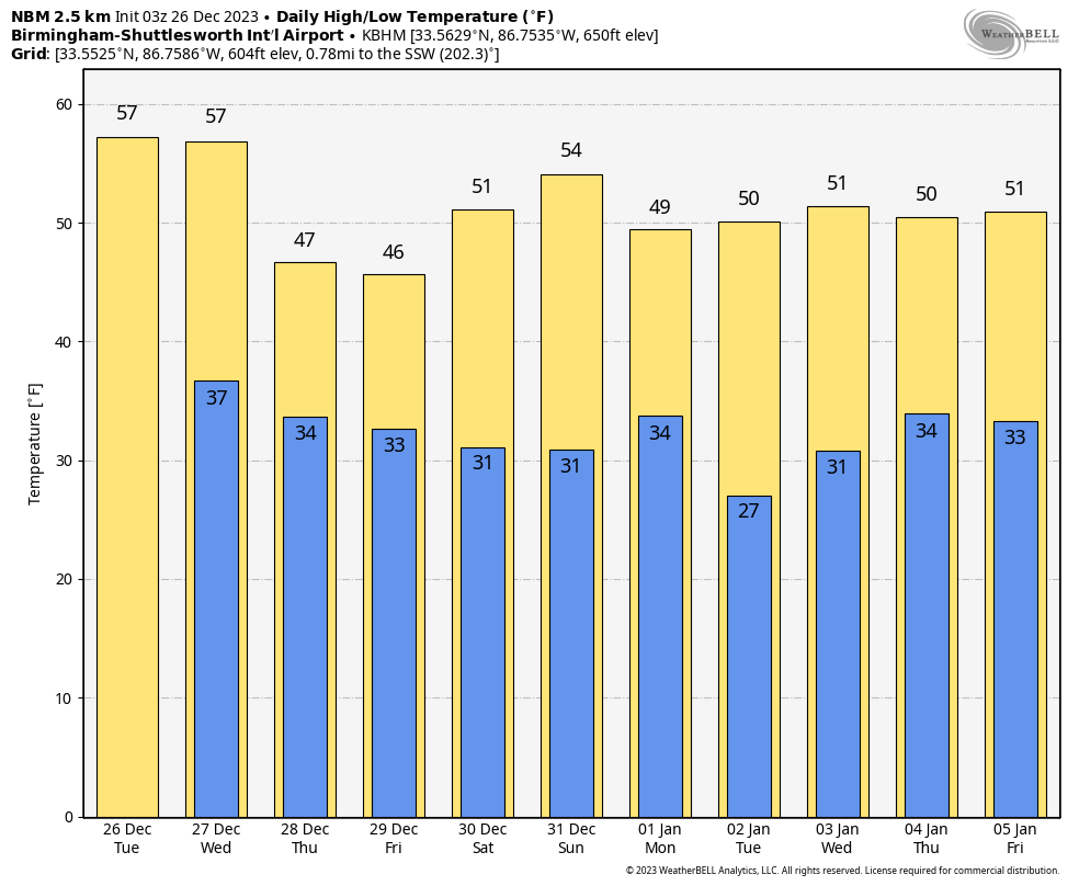
WEEKEND OUTLOOK: Partly cloudy skies will be the rule for Saturday and Sunday. Temperatures Saturday will be in the lower 50s with middle 50s on Sunday.
NEXT RAIN CHANCE: Will come on New Years Day as another upper-level low swings through the Tennessee Valley. It looks like at least a soaking rain. The question will be whether atmospheric profiles will be cold enough for snow over the northern third of the area. Only time and more model runs will hopefully lead to clarity.
BEACHCAST: Col and dry conditions will continue through the week ahead along the beautiful beaches of Alabama and Northwest Florida. Highs will be in the 60s today and tomorrow with 50s until the weekend, when the 60s will return. Lows will be in the 40s the next couple of nights, with 30s Friday and Saturday morning before the 40s return. Water temperatures are in the lower 60s. The rough surf and rip currents will die down by tonight.
Click here to see the Beach Forecast Center page.
DANCING WITH THE STATS: 78F at Pensacola tied the record for the warmest Christmas Day there.
ADVERTISE WITH US: Deliver your message to a highly engaged audience by advertising on the AlabamaWX.com website. We have a lot of big plans for this year. Don’t miss out! We can customize a creative, flexible, and affordable package that will suit your organization’s needs. Contact me, Bill Murray, at (205) 687-0782 and let’s talk.
WEATHERBRAINS: This week, the panel hosted Tom Skilling, who is retiring from WGN Chicago next year. Check out the show at www.WeatherBrains.com. You can also subscribe on iTunes. You can watch the show live on our new YouTube channel for the show.You will be able to see the show on the James Spann 24×7 weather channel on cable or directly over the air on the dot 2 feed.
ON THIS DATE IN 1778: The Hessian Storm dumped 18 inches of snow on southern New England. More than 50 people froze to death in the subzero weather that followed the snow. The storm was named for nine German mercenaries who froze to death at their posts in Newport, Rhode Island. Many ships were wrecked in the terrible gales that accompanied the storm, including the General Arnold, an American ship that sunk off Plymouth, Massachusetts. Follow my weather history tweets on Twitter. I am @wxhistorian at Twitter.com.
Category: Alabama's Weather, ALL POSTS
About the Author (Author Profile)
Bill Murray is the President of The Weather Factory. He is the site's official weather historian and a weekend forecaster. He also anchors the site's severe weather coverage. Bill Murray is the proud holder of National Weather Association Digital Seal #0001 @wxhistorianSubscribe
If you enjoyed this article, subscribe to receive more just like it.


