

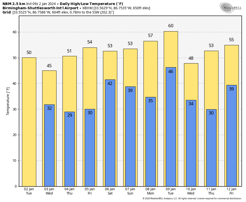
Sunny Today; Cold/Wet Wednesday Ahead
COLD START: Temperatures are below freezing across most of Alabama this morning… but with sunshine in full supply today we project a high in the 50s for most places this afternoon. Communities near the Gulf Coast will exceed 60 degrees. Clouds will increase tonight.
COLD/WET DAY TOMORROW: A weak surface low will develop in the northern Gulf of Mexico, and will spread light rain into Alabama tomorrow morning. We note there could be a little sleet as the precipitation begins during the morning hours thanks to evaporative cooling, but there won’t be any impact if we see a few ice pellets.
The most widespread rain tomorrow will be over the southern 2/3 of the state, and rain amounts will be light, mostly under 1/2 inch. It will be a cold rain with temperatures hovering around 40 degrees much of the day.
There is a chance a few snow flakes will mix with the rain by late afternoon and early tomorrow night over Northeast Alabama thanks to dynamic cooling, but if that happens surface temperatures will be above freezing and there won’t be any accumulation or impact.
Dry air returns Thursday; with a sunny sky the high will be in the 50s.
FRIDAY AND THE WEEKEND: A dynamic weather system will bring clouds back into Alabama during the day Friday, and a soaking rain is likely Friday night into Saturday morning. Models are trending faster with this feature, suggesting most of the rain will come from 8:00 Friday night through 8:00 Saturday morning. Rain amounts of 1-2 inches are likely, and there could be a rumble of thunder near the Gulf Coast.
The rain should be out of the state by Saturday afternoon, and Sunday looks dry with a mostly sunny sky. Highs will be in the 50s over the weekend, right at seasonal averages for early January.
NEXT WEEK: The daytime hours Monday will be mostly dry, but a vigorous system will bring another big rain event to the Deep South Monday night into Tuesday. This one also has potential for 1-2 inches of rain, and strong storms could be an issue for the southern counties of the state. And, yet another rain producer will arrive late in the week on Friday. Highs will be mostly in the 50s through the week… See the video briefing for maps, graphics, and more details.
ON THIS DATE IN 1955: Hurricane Alice passed through the Islands of Saint Martin and Saba in the Caribbean Sea on this day. Alice, which developed on December 30, 1954, is the only known Atlantic hurricane to span two calendar years.
ON THIS DATE IN 2017: An EF2 tornado tracked for 5.59 miles through parts of Geneva and Houston Counties in SE Alabama. Extensive tree damage occurred, with some trees being debarked. Several buildings were demolished at the National Peanut Festival grounds.
ON THIS DATE IN 2022: Heavy snow came down across the Tennessee Valley region of North Alabama with 2-4 inches of snow common and pockets of 5-7 inches. Across Central Alabama, totals were much lower, generally a dusting to one-half inch, primarily on elevated surfaces such as decks, roofs, and vehicles.
Look for the next video briefing here by 3:00 this afternoon… enjoy the day!
Category: Alabama's Weather, ALL POSTS, Weather Xtreme Videos
About the Author (Author Profile)
James Spann is one of the most recognized and trusted television meteorologists in the industry. He holds the AMS CCM designation and television seals from the AMS and NWA. He is a past winner of the Broadcast Meteorologist of the Year from both professional organizations.Subscribe
If you enjoyed this article, subscribe to receive more just like it.


